File:Karte Kattegat.png
Jump to navigation
Jump to search
Size of this preview: 506 × 600 pixels. Other resolutions: 202 × 240 pixels | 405 × 480 pixels | 660 × 782 pixels.
Original file (660 × 782 pixels, file size: 173 KB, MIME type: image/png)
Captions
Captions
Add a one-line explanation of what this file represents
| Description |
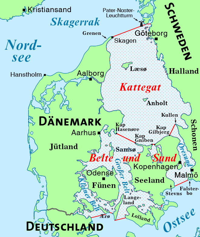
Deutsch: Karte des Kattegats
English: Map of the Kattegat |
| Date | |
| Source | Own work, using this file by NNW |
| Author | Maximilian Dörrbecker (Chumwa) |
| Permission (Reusing this file) |
I, the copyright holder of this work, hereby publish it under the following license: This file is licensed under the Creative Commons Attribution-Share Alike 2.5 Generic license.
Sie dürfen das Bild zu den folgenden Bedingungen nutzen:
|
| Other versions |
|


File history
Click on a date/time to view the file as it appeared at that time.
| Date/Time | Thumbnail | Dimensions | User | Comment | |
|---|---|---|---|---|---|
| current | 10:02, 8 November 2020 | | 660 × 782 (173 KB) | Chumwa (talk | contribs) | Diverses: Kartenbeschnitt, Lagekorrekturen, Aufteilung in zwei Meeresbereiche |
| 15:28, 21 May 2018 |  | 940 × 1,123 (233 KB) | Chumwa (talk | contribs) | Lage des Pater-Noster-Leuchtturms korrigiert | |
| 10:29, 24 December 2017 |  | 940 × 1,123 (235 KB) | Chumwa (talk | contribs) | Hervorhebung geändert | |
| 20:09, 19 January 2012 |  | 940 × 1,123 (222 KB) | Chumwa (talk | contribs) | {{Information |Description= {{de|1=Karte des Kattegats}} {{en|1=Map of the Kattegat}} |Source={{own}}, using this file by NNW |Date=2012-01 |Author= Maximilian Dörrbecker ([[: |
You cannot overwrite this file.
File usage on Commons
The following 5 pages use this file:
File usage on other wikis
The following other wikis use this file:
- Usage on ar.wikipedia.org
- Usage on da.wikipedia.org
- Usage on da.wiktionary.org
- Usage on de.wikipedia.org
- Usage on frr.wikipedia.org
- Usage on fr.wikipedia.org
- Usage on hr.wikipedia.org
- Usage on hsb.wikipedia.org
- Usage on hu.wikipedia.org
- Usage on it.wikipedia.org
- Usage on lt.wikipedia.org
- Usage on ru.wikipedia.org
- Usage on uk.wikipedia.org