File:Karte Helvetik 3.png
Jump to navigation
Jump to search
Size of this preview: 800 × 505 pixels. Other resolutions: 320 × 202 pixels | 640 × 404 pixels | 1,024 × 646 pixels | 1,280 × 807 pixels | 2,500 × 1,577 pixels.
Original file (2,500 × 1,577 pixels, file size: 806 KB, MIME type: image/png)
Captions
Captions
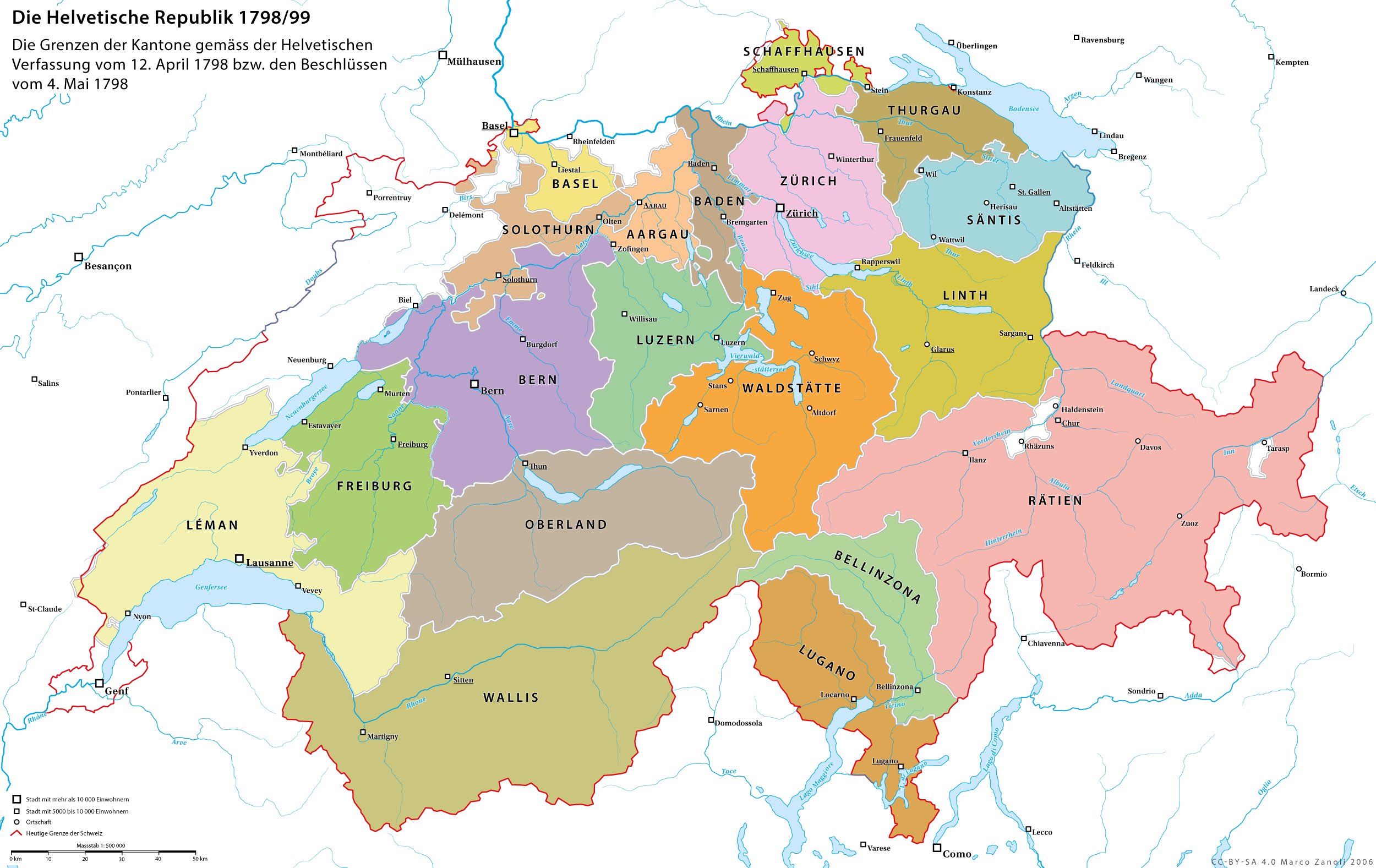
The Helvetic Republic after the annexation of Graubünden
Summary[edit]
| Description |
Deutsch: Die Helvetische Republik nach dem Anschluss Graubündens als 19. Kanton am 21.4.1799. Die Helvetische Verfassung wurde am 12.4.1798 in Aarau durch zwölf Kantone (Aargau, Baden, Basel, Bern, Freiburg, Leman, Luzern, Oberland, Schaffhausen, Solothurn, Thurgau und Zürich) beschlossen. Am 4.5.1798 wurde die Bildung von weiteren drei Kantonen (Waldstätte, Linth, Säntis) durch die Zusammenfassung der durch Frankreich unterworfenen Gebiete verfügt |
|
| Date | ||
| Source | Own work | |
| Author | Marco Zanoli | |
| Permission (Reusing this file) |
|
|
| Other versions |
|


File history
Click on a date/time to view the file as it appeared at that time.
| Date/Time | Thumbnail | Dimensions | User | Comment | |
|---|---|---|---|---|---|
| current | 16:06, 13 February 2021 | | 2,500 × 1,577 (806 KB) | Sidonius (talk | contribs) | neues Format, kleinere Korrekturen |
| 09:32, 18 February 2017 |  | 2,500 × 1,570 (746 KB) | Sidonius (talk | contribs) | Heutige Schweizer Grenze durchgehend und etwas stärker akzentuiert | |
| 12:07, 8 December 2009 |  | 2,500 × 1,570 (505 KB) | Tryphon (talk | contribs) | Removed watermark. | |
| 21:16, 3 February 2009 |  | 2,500 × 1,570 (731 KB) | Sidonius (talk | contribs) | weisser Hintergrund | |
| 21:13, 3 February 2009 |  | 2,500 × 1,570 (1.44 MB) | Sidonius (talk | contribs) | Diessenhofen zu Schaffhausen (1798-1800) | |
| 17:44, 6 October 2007 |  | 2,500 × 1,570 (477 KB) | Sidonius (talk | contribs) | Kleinere Korrekturen | |
| 16:28, 14 October 2006 |  | 2,500 × 1,570 (457 KB) | Sidonius (talk | contribs) | {{Information |Description=Die Helvetische Republik nach dem Anschluss Graubündens als 19. Kanton am 21.4.1799. Die Helvetische Verfassung wurde am 12.4.1798 in Aarau durch zehn Kantone (Aargau, Basel, Bern, Freiburg, Leman, |
You cannot overwrite this file.
File usage on Commons
The following 13 pages use this file:
- Atlas of Switzerland
- Helvetic Republic
- User:Sidonius
- File:Historische Karte CH Rom 1-fr.png
- File:Karte Helvetik 1.png
- File:Karte Helvetik 2.png
- File:Karte Helvetik 3-EN.png
- File:Karte Helvetik 3-FR.png
- File:Karte Helvetik 3-fr.svg
- File:Karte Helvetik 3b.png
- File:Karte Helvetik 4.png
- File:Karte Helvetik 4 Malmaison.png
- File:Karte Helvetik 4 Malmaison2.png
File usage on other wikis
The following other wikis use this file:
- Usage on als.wikipedia.org
- Usage on bg.wikipedia.org
- Usage on bn.wikipedia.org
- Usage on ca.wikipedia.org
- Usage on cs.wikipedia.org
- Usage on de.wikipedia.org
- Schweiz
- Geschichte der Schweiz
- Helvetische Republik
- Mediation (Schweizer Geschichte)
- Kanton Säntis
- Kanton Linth
- Benutzer:Sidonius
- Kanton Waldstätten
- Kanton Bellinzona
- Kanton Sargans
- Verfassungen der Helvetischen Republik
- Schweizer Truppen in französischen Diensten 1798–1815
- Schweizer Truppen in englischen und britischen Diensten
- Usage on en.wikipedia.org
- Usage on es.wikipedia.org
- Usage on et.wikipedia.org
- Usage on eu.wikipedia.org
- Usage on fr.wikipedia.org
- Usage on he.wikipedia.org
- Usage on hy.wikipedia.org
- Usage on id.wikipedia.org
View more global usage of this file.