File:Karte Chiemgau.png
Jump to navigation
Jump to search

Size of this preview: 691 × 600 pixels. Other resolutions: 277 × 240 pixels | 553 × 480 pixels | 885 × 768 pixels | 1,180 × 1,024 pixels | 2,155 × 1,870 pixels.
Original file (2,155 × 1,870 pixels, file size: 1.33 MB, MIME type: image/png)
Captions
Captions
Add a one-line explanation of what this file represents
| Description |
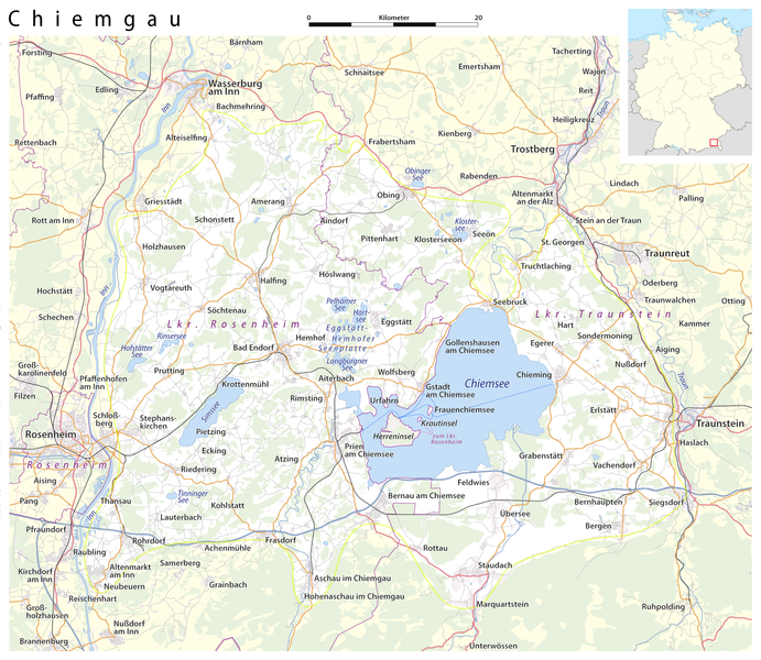
Deutsch: Karte: Chiemgau (Abgrenzung nach BfN)
English: Map: Chiemgau |
| Date | see file history |
| Source |
own work, using
|
| Author | Maximilian Dörrbecker (Chumwa) |
| Permission (Reusing this file) |
All OpenStreetMap data and maps are Creative Commons "CC-BY-SA 2.0" licensed This file is licensed under the Creative Commons Attribution-Share Alike 2.0 Generic license.
|
File history
Click on a date/time to view the file as it appeared at that time.
| Date/Time | Thumbnail | Dimensions | User | Comment | |
|---|---|---|---|---|---|
| current | 00:02, 5 June 2015 | | 2,155 × 1,870 (1.33 MB) | Cmdrjameson (talk | contribs) | Compressed with pngout. Reduced by 829kB (37% decrease). |
| 21:58, 6 November 2009 |  | 2,155 × 1,870 (2.14 MB) | Chumwa (talk | contribs) | Hemhofer Seenplatte → Eggstätt-Hemhofer Seenplatte | |
| 21:15, 4 November 2009 |  | 2,155 × 1,870 (2.14 MB) | Chumwa (talk | contribs) | Chiemseeinseln gehören zum Lkr. Rosenheim | |
| 06:51, 4 November 2009 |  | 2,155 × 1,870 (2.14 MB) | Chumwa (talk | contribs) | {{Information |Description={{de|Karte: Chiemgau}} {{en|Map: Chiemgau}} |Author=Maximilian Dörrbecker (Chumwa) |Source=own work, using * OpenStreetMap data for the background * [[:File:Germany_location_map.svg|t |
You cannot overwrite this file.
File usage on Commons
The following 5 pages use this file:
File usage on other wikis
The following other wikis use this file:
- Usage on an.wikipedia.org
- Usage on ar.wikipedia.org
- Usage on arz.wikipedia.org
- Usage on ca.wikipedia.org
- Usage on ceb.wikipedia.org
- Usage on de.wikipedia.org
- Usage on de.wikivoyage.org
- Usage on en.wikipedia.org
- Usage on eo.wikipedia.org
- Usage on es.wikipedia.org
- Usage on eu.wikipedia.org
- Usage on fr.wikipedia.org
- Usage on hu.wikipedia.org
- Usage on it.wikipedia.org
- Usage on nl.wikipedia.org
- Usage on pl.wikipedia.org
- Usage on pl.wikivoyage.org
- Usage on ro.wikipedia.org
- Usage on ru.wikipedia.org
- Usage on sr.wikipedia.org
- Usage on www.wikidata.org