File:Karte - Kesselschlachte bei Vjazma und Brjansk 1941.png
Jump to navigation
Jump to search
Size of this preview: 441 × 599 pixels. Other resolutions: 177 × 240 pixels | 353 × 480 pixels | 566 × 768 pixels | 754 × 1,024 pixels | 2,002 × 2,718 pixels.
Original file (2,002 × 2,718 pixels, file size: 1.56 MB, MIME type: image/png)
Captions
Captions
Add a one-line explanation of what this file represents
Summary[edit]
| Description |
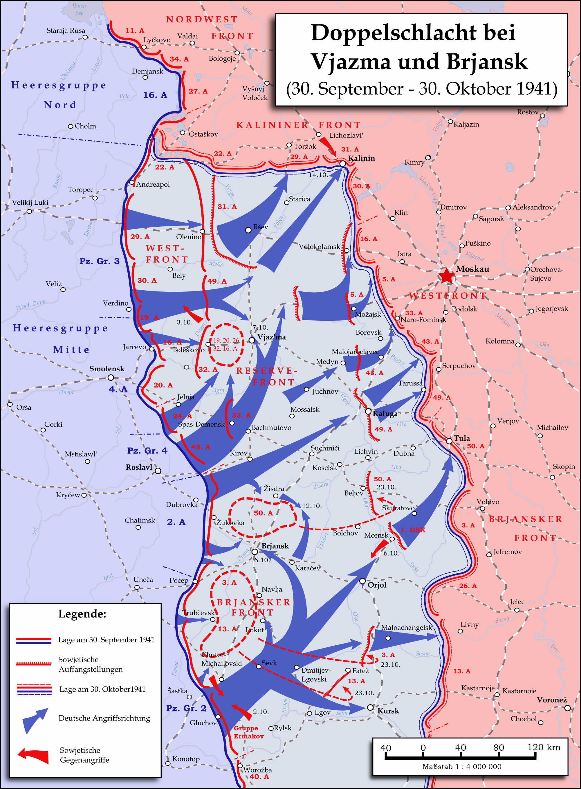
English: Map showing the two battles near Vyazma (October 2nd — October 20th 1941) and Brjansk (September 30th - October, 23rd) during the Second World War (1939—1945) at the Eastern Front. The map was created in Inkscape and is based on Map 30 in the attachment of the book P.N. Pospelow (Hrsg.): Geschichte des Großen Vaterländischen Krieges der Sowjetunion, Bd. 2, Berlin (Ost) 1963. The troop movements have been corrected.
Deutsch: Karte der Doppelschlacht im Raum Vjasma und Brjansk (30. September — 23. Oktober 1941) während des Zweiten Weltkrieges (1939—1945) an der Ostfront. Die Karte wurde mit Inkscape erstellt und basiert auf Karte Nr. 30 aus dem Anhang des Buches P.N. Pospelow (Hrsg.): Geschichte des Großen Vaterländischen Krieges der Sowjetunion, Bd. 2, Berlin (Ost) 1963. Die Truppenbewegungen wurden jedoch korrigiert. |
| Date | |
| Source | Own work |
| Author | Memnon335bc |
Licensing[edit]
I, the copyright holder of this work, hereby publish it under the following license:
This file is licensed under the Creative Commons Attribution 3.0 Unported license.
- You are free:
- to share – to copy, distribute and transmit the work
- to remix – to adapt the work
- Under the following conditions:
- attribution – You must give appropriate credit, provide a link to the license, and indicate if changes were made. You may do so in any reasonable manner, but not in any way that suggests the licensor endorses you or your use.
File history
Click on a date/time to view the file as it appeared at that time.
| Date/Time | Thumbnail | Dimensions | User | Comment | |
|---|---|---|---|---|---|
| current | 22:06, 31 May 2015 | | 2,002 × 2,718 (1.56 MB) | Cmdrjameson (talk | contribs) | Compressed with pngout. Reduced by 600kB (27% decrease). |
| 12:01, 18 September 2009 |  | 2,002 × 2,718 (2.15 MB) | Memnon335bc (talk | contribs) | {{Information |Description={{en|1=Map showing the Twin-Battlea near Vyazma (October 2nd — October 20th 1941) and Brjansk (September 30th - Octpber, 23rd) during the Second World War (1939—1945) at the Eastern Front. The map is created by Inkscape and |
You cannot overwrite this file.
File usage on Commons
The following 2 pages use this file:
File usage on other wikis
The following other wikis use this file:
- Usage on azb.wikipedia.org
- Usage on az.wikipedia.org
- Usage on ba.wikipedia.org
- Usage on be.wikipedia.org
- Usage on de.wikipedia.org
- Usage on en.wikipedia.org
- Usage on es.wikipedia.org
- Usage on et.wikipedia.org
- Usage on fr.wikipedia.org
- Usage on it.wikipedia.org
- Usage on ja.wikipedia.org
- Usage on nl.wikipedia.org
- Usage on pl.wikipedia.org
- Usage on pt.wikipedia.org
- Usage on ru.wikipedia.org
- Usage on sl.wikipedia.org
- Usage on th.wikipedia.org
- Usage on tr.wikipedia.org
- Usage on tt.wikipedia.org
- Usage on vi.wikipedia.org
- Usage on zh.wikipedia.org