File:Karta48.png
Jump to navigation
Jump to search

Size of this preview: 636 × 599 pixels. Other resolutions: 255 × 240 pixels | 510 × 480 pixels | 743 × 700 pixels.
Original file (743 × 700 pixels, file size: 25 KB, MIME type: image/png)
Captions
Captions
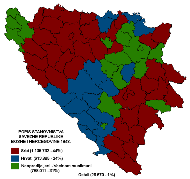
Map of the 1948. Population Census conducted in SR Bosnia and Herzegovina.
Summary[edit]
| Description |
English: Map of the 1948. Population Census conducted in SR Bosnia and Herzegovina.
Serbs are colored in red, Croats in blue, Ethnically undeclared (Mostly muslims) in green. The map uses municipality borders from 1953.Srpski (latinica): Karta iz 1948. Popisa stanovnistva koji je sproveden u SR Bosni i Hercegovini.
Srbi su u crvenoj boji, Hrvati u plavoj, Neopredijeljeni (Vecinom muslimani) u zelenoj. Mapa koristi granice opština iz 1953. |
| Date | |
| Source | Own work |
| Author | YugoSRB |
Licensing[edit]
I, the copyright holder of this work, hereby publish it under the following license:
This file is licensed under the Creative Commons Attribution-Share Alike 4.0 International license.
- You are free:
- to share – to copy, distribute and transmit the work
- to remix – to adapt the work
- Under the following conditions:
- attribution – You must give appropriate credit, provide a link to the license, and indicate if changes were made. You may do so in any reasonable manner, but not in any way that suggests the licensor endorses you or your use.
- share alike – If you remix, transform, or build upon the material, you must distribute your contributions under the same or compatible license as the original.
File history
Click on a date/time to view the file as it appeared at that time.
| Date/Time | Thumbnail | Dimensions | User | Comment | |
|---|---|---|---|---|---|
| current | 08:00, 22 January 2019 | | 743 × 700 (25 KB) | YugoSRB (talk | contribs) | User created page with UploadWizard |
You cannot overwrite this file.
File usage on Commons
The following page uses this file:
File usage on other wikis
The following other wikis use this file:
- Usage on sr.wikipedia.org