File:Karl Baedeker. Akka & Umgebung (1910) (14766736185).jpg
Original file (1,245 × 1,279 pixels, file size: 408 KB, MIME type: image/jpeg)
Captions
Captions
Summary[edit]
| Karl Baedeker: 'Akka & Umgebung
( |
|||||||||||||||||||||
|---|---|---|---|---|---|---|---|---|---|---|---|---|---|---|---|---|---|---|---|---|---|
| Artist |
|
||||||||||||||||||||
| Author |
| ||||||||||||||||||||
| Publisher | Leipzig : Baedeker | ||||||||||||||||||||
| Title |
'Akka & Umgebung |
||||||||||||||||||||
| Description |
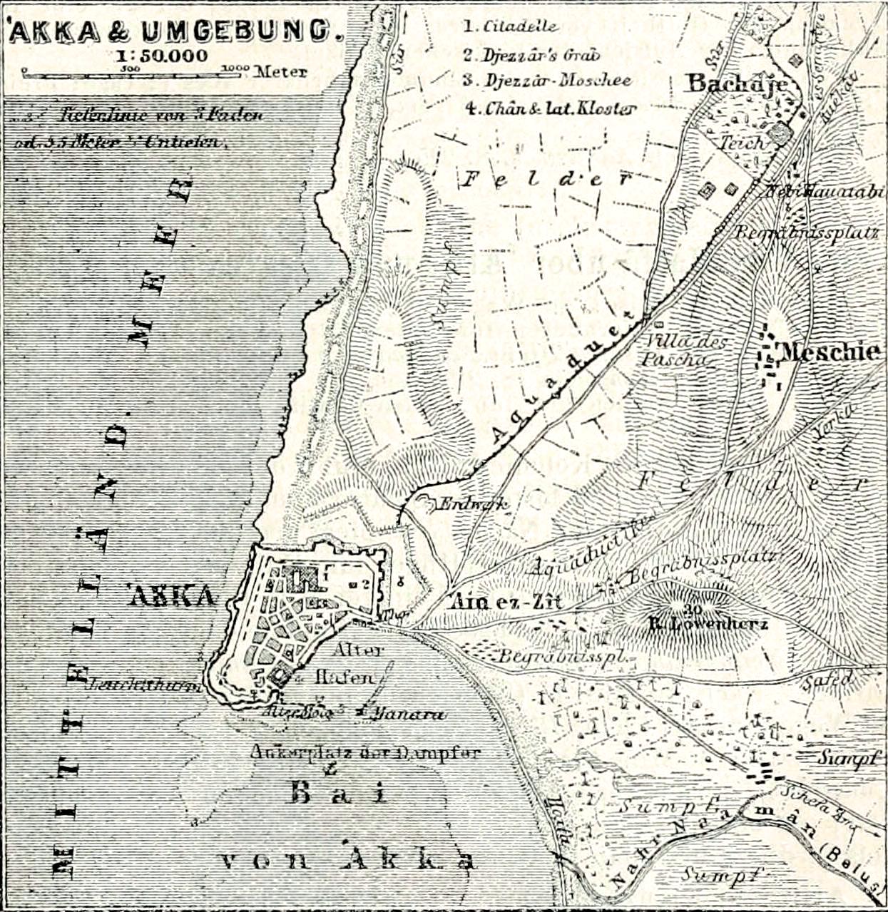
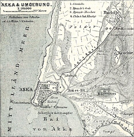
Text Appearing Before Image: Deutsch: ige Herrschaft, die im N. bis zum Hunds-tluß und Baalbek, im S. bis Cäsarea reichte. Besonders berühmt wurde erdurch seine Bauten ; er ließ zu diesem Zwecke antikes Material aus Askalon(S. 114), Cäsarea (S. 22(J) und andern Gegenden herbeischleppen. 1799 be-lagerte und bestürmte Napoleon die Stadt vergeblich. Dschezzär Pascha.starb 1804; unter seinem Sohne Solimän wurde das Land ruhiger und fried-licher regiert. 1832 eroberte und zerstörte Ibrahim Pascha die Stadt. Doch AKKA. 25. Route. 217 stets erhob sie sich wieder. 1840 wurde sie von den vereinigten Flotten Eng-lands und Österreichs bombardiert (S. Lxxxi). Daß nach solchen Ver-wüstungen fast keine Spuren höhereu Altertums sichtbar sind, ist begreiflich. Akkä, Hafenstadt von 12 000 Einwolinern (darunter 3000Christen und Juden), Sitz eines Mutesarrif, liegt auf einer kleinenLandzunge, an deren SO.-Spitze man im Wasser noch lieste einesMolo sieht. Das einzige Tor befindet sich auf der 0.-Seite. Die iky\/\ 7&wmmmmM§
Text Appearing After Image: «fi V ( iL A Is k.
|
||||||||||||||||||||
| Date | 1910 | ||||||||||||||||||||
| Notes |
View Book Page: Book Viewer About This Book: Catalog Entry View All Images: All Images From Book |
||||||||||||||||||||
| Source/Photographer |
Palästina und Syrien : die Hauptrouten Mesopotamiens und Babyloniens und die Insel Cypern; Handbuch für Reisende, with maps and plans, Karl Baedeker (Firm), P.342 |
||||||||||||||||||||

_(14766736185).jpg&action=edit§ion=1)
Licensing[edit]
_(14766736185).jpg&action=edit§ion=2)
|
This is a faithful photographic reproduction of a two-dimensional, public domain work of art. The work of art itself is in the public domain for the following reason:
The official position taken by the Wikimedia Foundation is that "faithful reproductions of two-dimensional public domain works of art are public domain".
This photographic reproduction is therefore also considered to be in the public domain in the United States. In other jurisdictions, re-use of this content may be restricted; see Reuse of PD-Art photographs for details. | ||||
| Annotations | This image is annotated: View the annotations at Commons |
_(14766736185).jpg)
File history
Click on a date/time to view the file as it appeared at that time.
| Date/Time | Thumbnail | Dimensions | User | Comment | |
|---|---|---|---|---|---|
| current | 01:09, 12 June 2015 | | 1,245 × 1,279 (408 KB) | Geagea (talk | contribs) | full map |
| 00:07, 12 June 2015 |  | 1,242 × 884 (263 KB) | Geagea (talk | contribs) | Transferred from Flickr via Flickr2Commons |
You cannot overwrite this file.
File usage on Commons
The following 5 pages use this file:
- User:Atamari/BotGallery/Geology/2015 June 11-20
- User:Geagea/Israel/2015 June 12
- User:Pechristener/Bridges/2015 June 11-20
- File:Image from page 342 of "Palästina und Syrien - die Hauptrouten Mesopotamiens und Babyloniens und die Insel Cypern; Handbuch für Reisende, with maps and plans" (1910) (14766736185).jpg (file redirect)
- File:Karl Baedeker. Akka & Umgebung (1910) (14766736185).jpg
_(14766736185).jpg&redirect=no)
_(14766736185).jpg)
File usage on other wikis
The following other wikis use this file:
- Usage on he.wikipedia.org
_(14766736185).jpg&oldid=428470896)