File:Kapen van Rottum -1800.jpg
Jump to navigation
Jump to search
No higher resolution available.
Kapen_van_Rottum_-1800.jpg (300 × 303 pixels, file size: 45 KB, MIME type: image/jpeg)
Captions
Captions
Add a one-line explanation of what this file represents
Summary
[edit]
| Description |
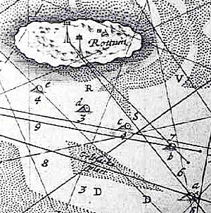
English: Old seamap from before 1800 with the island Rottum and two "kapen" (some sort of beacon for ships)
Nederlands: Oude zeekaart van voor 1800 met het eiland Rottum en twee kapen erop |
| Date | before 1800 |
| Source | Crop of old seamap |
| Author | Unknown author |
| Object location | | View this and other nearby images on: OpenStreetMap |
|---|
Licensing
[edit]
|
This work is in the public domain in its country of origin and other countries and areas where the copyright term is the author's life plus 100 years or fewer. | |
| This file has been identified as being free of known restrictions under copyright law, including all related and neighboring rights. | |
File history
Click on a date/time to view the file as it appeared at that time.
| Date/Time | Thumbnail | Dimensions | User | Comment | |
|---|---|---|---|---|---|
| current | 11:16, 25 September 2009 | | 300 × 303 (45 KB) | Romaine (talk | contribs) | {{Information |Description={{en|1=Old seamap from before 1800 with the island Rottum and two "kapen" (some sort of beacon for ships)}} {{nl|1=Oude zeekaart van voor 1800 met het eiland Rottum en twee kapen erop}} |Source=Crop |
You cannot overwrite this file.
File usage on Commons
There are no pages that use this file.
File usage on other wikis
The following other wikis use this file:
- Usage on fy.wikipedia.org
- Usage on nl.wikipedia.org