File:Kanton RedangeLocatie.png
Jump to navigation
Jump to search
No higher resolution available.
Kanton_RedangeLocatie.png (203 × 270 pixels, file size: 4 KB, MIME type: image/png)
Captions
Captions
Add a one-line explanation of what this file represents
Summary[edit]
| Description |
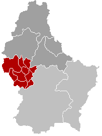
Lëtzebuergesch: De Kanton Réiden zu Lëtzebuerg. |
| Date | |
| Source |
English: This image was copied from nl.wikipedia.org. The original description was: Kantonkaart, eigen werk |
| Author |
|
| Other versions |
 |
Licensing[edit]
| This work has been released into the public domain by its author, LennartBolks. This applies worldwide. In some countries this may not be legally possible; if so: |
Original upload log[edit]
Transferred from nl.wikipedia to Commons.
The original description page was here. All following user names refer to nl.wikipedia.
File history
Click on a date/time to view the file as it appeared at that time.
| Date/Time | Thumbnail | Dimensions | User | Comment | |
|---|---|---|---|---|---|
| current | 15:05, 9 May 2006 | | 203 × 270 (4 KB) | Bastin8 (talk | contribs) | {{Information| |Description=Map of Redange canton within Luxembourg. |Source=Predecessor copied from nl.wikipedia.org. Updated to account for mergers of 2006-01-01. |Date=2006-05-09 |Author=User:Bastin8 |Permission=Released into the public domain. Se |
| 18:40, 22 December 2004 |  | 203 × 270 (3 KB) | LennartBolks~commonswiki (talk | contribs) | This image was copied from nl.wikipedia.org. The original description was: Kantonkaart, eigen werk {{PD}} nl:Afbeelding:Kanton RedangeLocatie.png |
You cannot overwrite this file.
File usage on Commons
The following 2 pages use this file:
File usage on other wikis
The following other wikis use this file:
- Usage on als.wikipedia.org
- Usage on ceb.wikipedia.org
- Usage on da.wikipedia.org
- Usage on de.wikipedia.org
- Usage on en.wikipedia.org
- Usage on es.wikipedia.org
- Usage on fa.wikipedia.org
- Usage on id.wikipedia.org
- Usage on it.wikipedia.org
- Usage on ko.wikipedia.org
- Usage on li.wikipedia.org
- Usage on lt.wikipedia.org
- Usage on lv.wikipedia.org
- Usage on nl.wikipedia.org
- Usage on no.wikipedia.org
- Usage on pt.wikipedia.org
- Usage on ro.wikipedia.org
- Usage on ru.wikipedia.org
- Usage on sk.wikipedia.org
- Usage on sv.wikipedia.org
- Usage on tr.wikipedia.org
- Usage on uk.wikipedia.org
- Usage on vi.wikipedia.org
- Usage on www.wikidata.org
- Usage on zh-min-nan.wikipedia.org
- Usage on zh.wikipedia.org
View more global usage of this file.