File:Kangee speaking areas.jpg
Jump to navigation
Jump to search

Size of this preview: 492 × 600 pixels. Other resolutions: 197 × 240 pixels | 394 × 480 pixels | 630 × 768 pixels | 840 × 1,024 pixels | 1,324 × 1,614 pixels.
Original file (1,324 × 1,614 pixels, file size: 524 KB, MIME type: image/jpeg)
Captions
Captions
Add a one-line explanation of what this file represents
| Description |
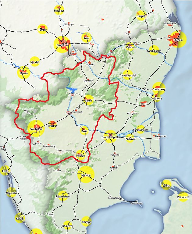
English: Map of the major urban areas in the state of en:Tamil Nadu, India. The map was made using data queried from the OpenStreetMap project, Natural Earth and processed using en:Quantum GIS. The size of the yellow circle represents the rank of the urban area while the red areas show the approximate extent of the city. Forest cover has been dereived from landsat imagery and is available in the OSM database. The Railway network data is currently incomplete for India on OSM. |
| Date | (UTC) |
| Source | |
| Author |
.png)
| This is a retouched picture, which means that it has been digitally altered from its original version. Modifications: Kangee speaking areas marked with red. The original can be viewed here: Tamil Nadu Urban Areas and Railway Connectivity Map (openstreetmap).png:
|
I, the copyright holder of this work, hereby publish it under the following license:
This file is licensed under the Creative Commons Attribution-Share Alike 3.0 Unported license.
- You are free:
- to share – to copy, distribute and transmit the work
- to remix – to adapt the work
- Under the following conditions:
- attribution – You must give appropriate credit, provide a link to the license, and indicate if changes were made. You may do so in any reasonable manner, but not in any way that suggests the licensor endorses you or your use.
- share alike – If you remix, transform, or build upon the material, you must distribute your contributions under the same or compatible license as the original.
Original upload log[edit]
This image is a derivative work of the following images:
- File:_Tamil_Nadu_Urban_Areas_and_Railway_Connectivity_Map_(openstreetmap).png licensed with Cc-by-sa-3.0
- 2010-04-28T05:31:47Z Planemad 1324x1768 (1450275 Bytes) updated railway network and forest from openstreetmap.org
- 2010-04-23T16:47:59Z Planemad 749x1000 (667955 Bytes) {{Information |Description={{en|1=Map of the major urban areas in the state of [[:en:Tamil Nadu]], India. The map was made using data from the [http://www.openstreetmap.org/?lat=10.51&lon=79.5&zoom=7&layers=B000FTF OpenStreet
Uploaded with derivativeFX
File history
Click on a date/time to view the file as it appeared at that time.
| Date/Time | Thumbnail | Dimensions | User | Comment | |
|---|---|---|---|---|---|
| current | 07:45, 19 April 2011 | | 1,324 × 1,614 (524 KB) | Pandyaboy (talk | contribs) | {{Information |Description={{en|1=Map of the major urban areas in the state of en:Tamil Nadu, India. The map was made using data queried from the [http://www.openstreetmap.org/?lat=10.51&lon=79.5&zoom=7&layers=B000FTF OpenStreetMap] project, Natural |
You cannot overwrite this file.
File usage on Commons
There are no pages that use this file.