File:Kaitak tchn.svg
Jump to navigation
Jump to search

Size of this PNG preview of this SVG file: 494 × 600 pixels. Other resolutions: 198 × 240 pixels | 395 × 480 pixels | 632 × 768 pixels | 843 × 1,024 pixels | 1,686 × 2,048 pixels | 988 × 1,200 pixels.
Original file (SVG file, nominally 988 × 1,200 pixels, file size: 230 KB)
Captions
Captions
Add a one-line explanation of what this file represents
Summary[edit]
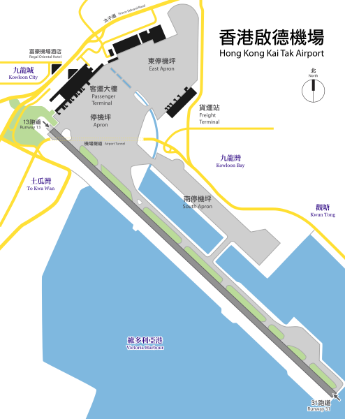
| Description | Plan view of Hong Kong Kai Tak Airport with Traditional Chinese text. Originaly PNG by Toblerone, traced by me using Inkscape. |
| Date | |
| Source | File:Kaitak-Airport-Plan.png |
| Author | User:Antilived, User:Toblerone |
| Other versions | Simplified Chinese version |
| SVG development | This W3C-invalid map was created with Adobe Illustrator, and with Inkscape. |
Licensing[edit]
I, the copyright holder of this work, hereby publish it under the following license:
This file is licensed under the Creative Commons Attribution-Share Alike 2.5 Generic license.
- You are free:
- to share – to copy, distribute and transmit the work
- to remix – to adapt the work
- Under the following conditions:
- attribution – You must give appropriate credit, provide a link to the license, and indicate if changes were made. You may do so in any reasonable manner, but not in any way that suggests the licensor endorses you or your use.
- share alike – If you remix, transform, or build upon the material, you must distribute your contributions under the same or compatible license as the original.
File history
Click on a date/time to view the file as it appeared at that time.
| Date/Time | Thumbnail | Dimensions | User | Comment | |
|---|---|---|---|---|---|
| current | 05:54, 26 January 2010 | | 988 × 1,200 (230 KB) | Mikepanhu (talk | contribs) | Layer fixed. |
| 05:51, 26 January 2010 |  | 988 × 1,200 (230 KB) | Mikepanhu (talk | contribs) | Font outlined. | |
| 05:47, 26 January 2010 |  | 988 × 1,200 (82 KB) | Mikepanhu (talk | contribs) | Small modification about the fonts and graphics. | |
| 02:00, 24 December 2006 |  | 988 × 1,200 (253 KB) | Antilived (talk | contribs) | kaitak -> kai tak, corrected simp. chinese in trad. chinese version | |
| 03:12, 23 December 2006 |  | 988 × 1,200 (248 KB) | Antilived (talk | contribs) | moving the label that I missed from last time... | |
| 03:07, 23 December 2006 |  | 988 × 1,200 (248 KB) | Antilived (talk | contribs) | changed position of some label so they fit into the image | |
| 03:02, 23 December 2006 |  | 988 × 1,200 (248 KB) | Antilived (talk | contribs) | added english labels | |
| 07:01, 9 July 2006 |  | 988 × 1,200 (237 KB) | Antilived (talk | contribs) | converted all text to paths to combat the server rendering problem | |
| 06:56, 9 July 2006 |  | 988 × 1,200 (43 KB) | Antilived (talk | contribs) | {{Information |Description= Plan view of Hong Kong Kai Tak Airport with Traditional Chinese text. Originaly PNG by Toblerone, traced by me using Inkscape. |Source= Image:Kaitak-Airport-Plan.png |Date= 2006-07-09 |Au |
You cannot overwrite this file.
File usage on Commons
The following page uses this file:
File usage on other wikis
The following other wikis use this file:
- Usage on de.wikipedia.org
- Usage on en.wikipedia.org
- Usage on fr.wikipedia.org
- Usage on he.wikipedia.org
- Usage on id.wikipedia.org
- Usage on it.wikipedia.org
- Usage on ko.wikipedia.org
- Usage on no.wikipedia.org
- Usage on pl.wikipedia.org
- Usage on ru.wikipedia.org
- Usage on vi.wikipedia.org
- Usage on zh-yue.wikipedia.org
- Usage on zh.wikipedia.org