File:KYphysiography.jpg
From Wikimedia Commons, the free media repository
Jump to navigation
Jump to search

Size of this preview: 800 × 353 pixels. Other resolutions: 320 × 141 pixels | 824 × 364 pixels.
Original file (824 × 364 pixels, file size: 159 KB, MIME type: image/jpeg)
File information
Structured data
Captions
Captions
Add a one-line explanation of what this file represents

|
This map image could be re-created using vector graphics as an SVG file. This has several advantages; see Commons:Media for cleanup for more information. If an SVG form of this image is available, please upload it and afterwards replace this template with
{{vector version available|new image name}}.
It is recommended to name the SVG file “KYphysiography.svg”—then the template Vector version available (or Vva) does not need the new image name parameter. |
 | This map image was uploaded in the JPEG format even though it consists of non-photographic data. This information could be stored more efficiently or accurately in the PNG or SVG format. If possible, please upload a PNG or SVG version of this image without compression artifacts, derived from a non-JPEG source (or with existing artifacts removed). After doing so, please tag the JPEG version with {{Superseded|NewImage.ext}} and remove this tag. This tag should not be applied to photographs or scans. If this image is a diagram or other image suitable for vectorisation, please tag this image with {{Convert to SVG}} instead of {{BadJPEG}}. If not suitable for vectorisation, use {{Convert to PNG}}. For more information, see {{BadJPEG}}. |
Summary[edit]
| DescriptionKYphysiography.jpg |
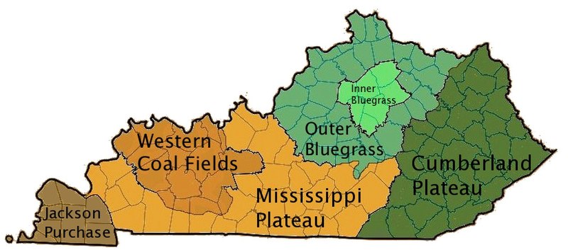
English: I created this image using Wikipedia's map of Kentucky counties.
|
| Date | 1 May 2007 (original upload date) |
| Source | Transferred from en.wikipedia to Commons by byankno1. |
| Author | Lamontacranston at English Wikipedia |
Licensing[edit]
| Public domainPublic domainfalsefalse |
| This work has been released into the public domain by its author, Lamontacranston at English Wikipedia. This applies worldwide. In some countries this may not be legally possible; if so: Lamontacranston grants anyone the right to use this work for any purpose, without any conditions, unless such conditions are required by law.Public domainPublic domainfalsefalse |
Original upload log[edit]
The original description page was here. All following user names refer to en.wikipedia.
- 2007-05-01 00:01 Lamontacranston 824×364× (162592 bytes) Bigger fonts. I created this image.
- 2007-04-30 23:54 Lamontacranston 824×364× (154693 bytes) Added text, improved edges, slightly lightened colors. I created the original.
- 2006-09-09 19:16 Lamontacranston 824×364× (55286 bytes) I created this image using Wikipedia's map of Kentucky counties.
File history
Click on a date/time to view the file as it appeared at that time.
| Date/Time | Thumbnail | Dimensions | User | Comment | |
|---|---|---|---|---|---|
| current | 16:36, 18 November 2008 |  | 824 × 364 (159 KB) | EpcotMagic (talk | contribs) | {{Information |Description={{en|I created this image using Wikipedia's map of Kentucky counties. *Dark green - Eastern Kentucky Coal fields (Cumberland Plateau) *Green - Outer Bluegrass *Light Green - Inner Bluegrass *Light Brown - Mississippi (Pennyroyal |
You cannot overwrite this file.
File usage on Commons
There are no pages that use this file.
File usage on other wikis
The following other wikis use this file:
- Usage on ar.wikipedia.org
- Usage on de.wikipedia.org
- Usage on el.wikipedia.org
- Usage on en.wikipedia.org
- Usage on es.wikipedia.org
- Usage on fi.wikipedia.org
- Usage on he.wikipedia.org
- Usage on ia.wikipedia.org
- Usage on id.wikipedia.org
- Usage on it.wikipedia.org
- Usage on ja.wikipedia.org
- Usage on no.wikipedia.org
- Usage on pt.wikipedia.org
- Usage on sh.wikipedia.org
- Usage on simple.wikipedia.org
- Usage on sv.wikipedia.org
- Usage on vi.wikipedia.org
- Usage on zh.wikipedia.org
Metadata
This file contains additional information such as Exif metadata which may have been added by the digital camera, scanner, or software program used to create or digitize it. If the file has been modified from its original state, some details such as the timestamp may not fully reflect those of the original file. The timestamp is only as accurate as the clock in the camera, and it may be completely wrong.
| _error | 0 |
|---|
