File:KARTA(MAPA) NA KOJA SE PRIKAZANI MAKEDONCITE KAKO POSEBEN NAROD Ethnographical Map of Central and South Eastern Europe - The War Office 1916, London.jpg
Jump to navigation
Jump to search

Size of this preview: 708 × 599 pixels. Other resolutions: 284 × 240 pixels | 567 × 480 pixels | 908 × 768 pixels | 1,210 × 1,024 pixels | 1,770 × 1,498 pixels.
Original file (1,770 × 1,498 pixels, file size: 969 KB, MIME type: image/jpeg)
Captions
Captions
Add a one-line explanation of what this file represents
Summary[edit]
_NA_KOJA_SE_PRIKAZANI_MAKEDONCITE_KAKO_POSEBEN_NAROD_Ethnographical_Map_of_Central_and_South_Eastern_Europe_-_The_War_Office_1916,_London.jpg&action=edit§ion=1)
| Description |
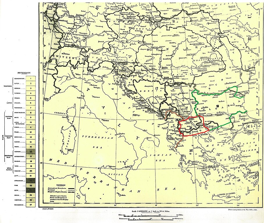
English: Macedonians under No.27 separate from other nation in Balkan Peninsula by the war office 1916, London and published in Daily Telegraph Македонски: Makedoncite objaveni na ovaa mapa posebno od okolnite Balkanski narodi pod brojot 27 !!! Mapata e izdadena od britanskoto ministerstvo za odbrana 1916 godina |
| Date | |
| Source | Own work |
| Author | DraganKitanoski |
| Camera location | | View this and other nearby images on: OpenStreetMap |
|---|
_NA_KOJA_SE_PRIKAZANI_MAKEDONCITE_KAKO_POSEBEN_NAROD_Ethnographical_Map_of_Central_and_South_Eastern_Europe_-_The_War_Office_1916,_London.jpg¶ms=041.240000_N_0020.592800_E_globe:Earth_type:camera__&language=en)
Licensing[edit]
_NA_KOJA_SE_PRIKAZANI_MAKEDONCITE_KAKO_POSEBEN_NAROD_Ethnographical_Map_of_Central_and_South_Eastern_Europe_-_The_War_Office_1916,_London.jpg&action=edit§ion=2)
I, the copyright holder of this work, hereby publish it under the following license:
This file is licensed under the Creative Commons Attribution-Share Alike 3.0 Unported license.
- You are free:
- to share – to copy, distribute and transmit the work
- to remix – to adapt the work
- Under the following conditions:
- attribution – You must give appropriate credit, provide a link to the license, and indicate if changes were made. You may do so in any reasonable manner, but not in any way that suggests the licensor endorses you or your use.
- share alike – If you remix, transform, or build upon the material, you must distribute your contributions under the same or compatible license as the original.
File history
Click on a date/time to view the file as it appeared at that time.
| Date/Time | Thumbnail | Dimensions | User | Comment | |
|---|---|---|---|---|---|
| current | 19:34, 2 December 2012 | | 1,770 × 1,498 (969 KB) | DraganKitanoski (talk | contribs) | User created page with UploadWizard |
You cannot overwrite this file.
File usage on Commons
There are no pages that use this file.
_NA_KOJA_SE_PRIKAZANI_MAKEDONCITE_KAKO_POSEBEN_NAROD_Ethnographical_Map_of_Central_and_South_Eastern_Europe_-_The_War_Office_1916,_London.jpg&oldid=479247827)