File:Judaea seu Palaestina map by Homann c1741.jpg

From Wikimedia Commons, the free media repository
Jump to navigation Jump to search

Original file(2,953 × 2,561 pixels, file size: 4.48 MB, MIME type: image/jpeg)
Captions

Captions

Add a one-line explanation of what this file represents

Summary[edit]

Description
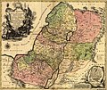
English: Judaea seu Palaestina ob sacratisima Redemtoris vestigia hodie dicta Terra Sancta prout olim In Duodecim Tribus Divisa separatis ab invicem Regnis Iuda Et Israel.

Map of the Holy Land with an inset map of the southern Holy Land extending into Egypt with a rocky landscape with four figures. The title cartouche shows Moses accepting the Ten Commandments. Image Size:485mm x 565mm, Sheet Size:515mm x 605mm-

Technique:Hand coloured copper engraving.
Date circa 1741
date QS:P,+1741-00-00T00:00:00Z/9,P1480,Q5727902
Source https://antiqueprintmaproom.com/antique-maps-plans/antique-maps-middle-east-holy-land-turkey/judaea-seu-palaestina-ob-sacratisima-redemtoris-ve-johann-baptist-homann
Author Johann Baptist Homann (1663-1724)
Other versions

Licensing[edit]

Public domain

This work is in the public domain in its country of origin and other countries and areas where the copyright term is the author's life plus 70 years or fewer.


This work is in the public domain in the United States because it was published (or registered with the U.S. Copyright Office) before January 1, 1929.

File history

Click on a date/time to view the file as it appeared at that time.

Date/TimeThumbnailDimensionsUserComment
current15:10, 15 June 2020Thumbnail for version as of 15:10, 15 June 20202,953 × 2,561 (4.48 MB)Ratzer (talk | contribs)Uploaded a work by Johann Baptist Homann (1663-1724) from https://antiqueprintmaproom.com/antique-maps-plans/antique-maps-middle-east-holy-land-turkey/judaea-seu-palaestina-ob-sacratisima-redemtoris-ve-johann-baptist-homann with UploadWizard

There are no pages that use this file.

File usage on other wikis

The following other wikis use this file: