File:Jorge Aguiar 1492 MR.jpg
Jump to navigation
Jump to search

Size of this preview: 776 × 600 pixels. Other resolutions: 311 × 240 pixels | 621 × 480 pixels | 994 × 768 pixels | 1,280 × 990 pixels | 2,560 × 1,979 pixels | 5,016 × 3,878 pixels.
Original file (5,016 × 3,878 pixels, file size: 13.06 MB, MIME type: image/jpeg)
Captions
Captions
Add a one-line explanation of what this file represents
Summary[edit]
_en.png)
.png)
.jpg)
Licensing[edit]
|
This work is in the public domain in its country of origin and other countries and areas where the copyright term is the author's life plus 100 years or fewer. | |
| This file has been identified as being free of known restrictions under copyright law, including all related and neighboring rights. | |
Assessment[edit]
|
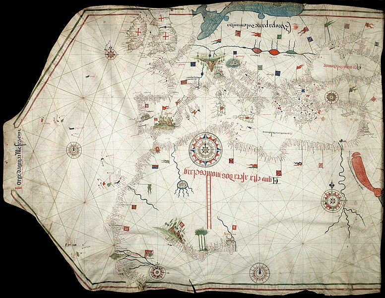
This image was selected as picture of the day on Wikimedia Commons for 10 June 2011. It was captioned as follows: English: Reproduction of Jorge de Aguiar's chart of the Mediterranean, Western Europe and African Coast (1492). Size of the original: 1030×770 mm Other languages:
Deutsch: Reproduktion von Jorge de Aguiars Karte des Mittelmeerraumes, der westeuropäischen und afrikanischen Küste aus dem Jahr 1492 – Größe des Originales: 1.030 mm × 770 mm English: Reproduction of Jorge de Aguiar's chart of the Mediterranean, Western Europe and African Coast (1492). Size of the original: 1030×770 mm Español: Reproducción del mapa de Jorge de Aguiar de la cuenca mediterránea, Europa Occidental y la costa africana (1492). Tamaño del original: 1030×770 mm. Esperanto: Reproduktaĵo de mapo pri la mediteraneaj, okcidenteŭropaj kaj afrikaj marbordoj, farita de la kartografo Jorge de Aguiar en 1492. Mezuroj de la originalo: 1030×770 mm. Français : Reproduction de la carte des côtes méditerranéenne, d'Europe et d'Afrique de l'Ouest par Jorge de Aguiar (1492). Italiano: Riproduzione della carta di Jorge de Aguiar delle coste del Mediterraneo, dell'Europa occidentale e dell'Africa settenrionale (1492). Dimensioni dell'originale: 1030×770 mm Magyar: Jorge de Aguiar térképének másolata: a Mediterrán térség, Nyugat-Európa, és az Afrikai part (1492). Méret: 1030×770 mm Nederlands: Een reproductie van de kaart van de hand van Jorge de Aguiar van de Middellandse Zee, West-Europa en de Afrikaanse kust (1492). Het origineel is 1030×770 mm. Русский: Репродукция карты Средиземного Моря, Европы и африканского побережья, составленной Хорхе де Агияром (1492). Українська: Відтворення карти Середземномор'я, Західної Європи і африканського узбережжя португальського картографа Хорхе де Агілара (Jorge de Aguiar) (1492). Розмір оригіналу: 1030×770 мм. Із зібрань Бібліотеки Бейнеке рідких книг і рукописів (Beinecke Rare Book & Manuscript Library) Єльського університету 日本語: ジョルジュ・デ・アギアルによる地中海、西ヨーロッパ及びアフリカ沿岸の海図(1492年)の複製。原画の寸法1030ミリメートル×770ミリメートル。 中文: 乔治·德阿吉亚尔绘制的地中海、西欧和非洲海岸图(1492年)复制品。原始尺寸:1030×770mm。 |
File history
Click on a date/time to view the file as it appeared at that time.
| Date/Time | Thumbnail | Dimensions | User | Comment | |
|---|---|---|---|---|---|
| current | 12:32, 24 November 2010 | | 5,016 × 3,878 (13.06 MB) | Alvesgaspar (talk | contribs) | {{Information |Description={{en|1=Reproduction of Jorge de Aguiar's chart of the Mediterranean, Western Europe and African Coast (1492). Size of the origial: 1030 x 770 mm}} |Source=Beinecke Rare Book and Manuscript Library, University of Yale, New Have, |
You cannot overwrite this file.
File usage on Commons
The following 37 pages use this file:
- User:Alvesgaspar/Maps & charts
- User talk:Alvesgaspar/archive17
- Commons:Featured picture candidates/File:Jorge Aguiar 1492 MR.jpg
- Commons:Featured picture candidates/Log/December 2010
- Commons:Featured pictures/Non-photographic media/Maps
- Commons:Featured pictures/chronological/2010-B
- Commons:Picture of the Year/2010/Galleries/Artworks
- Commons:Picture of the Year/2010/Galleries/Artworks/Large
- Commons:Picture of the Year/2010/Galleries/Artworks/Small
- Commons:Picture of the Year/2010/Galleries/Index/15
- Commons:Picture of the Year/2010/Galleries/Index/Artworks
- Commons:Picture of the Year/2010/Galleries/Table
- Commons:Picture of the Year/2010/Galleries/Table/12
- Commons:Picture of the Year/2010/R1/File:Jorge Aguiar 1492 MR.jpg
- Commons:Picture of the Year/2010/Results/R1/ALL/Table
- Commons:Picture of the Year/2010/Results/R1/Artworks
- Commons:Picture of the Year/2010/Results/R1/Artworks/Table
- Commons:Potd/2011-06 (de)
- Commons:Potd/2011-06 (nl)
- Commons:Potd/2011-06 (pt)
- Commons talk:Picture of the Year/2010/Galleries/Table
- Commons talk:Picture of the Year/2010/Results/R1/ALL/Table
- Template:Potd/2011-06
- Template:Potd/2011-06-10
- Template:Potd/2011-06-10 (de)
- Template:Potd/2011-06-10 (en)
- Template:Potd/2011-06-10 (eo)
- Template:Potd/2011-06-10 (es)
- Template:Potd/2011-06-10 (fr)
- Template:Potd/2011-06-10 (hu)
- Template:Potd/2011-06-10 (it)
- Template:Potd/2011-06-10 (ja)
- Template:Potd/2011-06-10 (nl)
- Template:Potd/2011-06-10 (ru)
- Template:Potd/2011-06-10 (uk)
- Template:Potd/2011-06-10 (zh-hans)
- Template:Potd/2011-06 (zh-hans)
File usage on other wikis
The following other wikis use this file:
- Usage on ar.wikipedia.org
- Usage on ba.wikipedia.org
- Usage on be-tarask.wikipedia.org
- Usage on bn.wikipedia.org
- Usage on ca.wikipedia.org
- Usage on crh.wikipedia.org
- Usage on cv.wikipedia.org
- Usage on en.wikipedia.org
- Portal:Geography
- User:Alvesgaspar
- Portolan chart
- Wikipedia:Featured pictures/Diagrams, drawings, and maps/Maps
- Wikipedia:Featured pictures thumbs/26
- Wikipedia:Featured picture candidates/December-2010
- Wikipedia:Featured picture candidates/File:Jorge Aguiar 1492 MR.jpg
- Wikipedia:Wikipedia Signpost/2010-12-27/Features and admins
- Iberian cartography, 1400–1600
- Talk:Iberian cartography, 1400–1600
- Template:POTD/2011-06-10
- Wikipedia:Picture of the day/June 2011
- Wikipedia:Main Page history/2011 June 10
- User:Walrasiad/Maps
- User talk:Alvesgaspar/archive2
- Wikipedia:Wikipedia Signpost/Single/2010-12-27
- Portal:Geography/Selected picture
- Usage on es.wikipedia.org
- Usage on fa.wikipedia.org
- Usage on fr.wikipedia.org
- Usage on hu.wikipedia.org
- Usage on it.wikipedia.org
- Usage on kk.wikipedia.org
- Usage on ko.wikipedia.org
- Usage on lbe.wikipedia.org
- Usage on oc.wikipedia.org
- Usage on os.wikipedia.org
- Usage on pl.wikipedia.org
- Usage on pt.wikipedia.org
- Usage on ro.wikipedia.org
- Usage on ru.wikipedia.org
- Usage on ru.wikinews.org
View more global usage of this file.