File:Jefferson-pier.jpg
Jump to navigation
Jump to search
No higher resolution available.
Jefferson-pier.jpg (415 × 392 pixels, file size: 31 KB, MIME type: image/jpeg)
Captions
Captions
Add a one-line explanation of what this file represents
Summary[edit]
| Description |
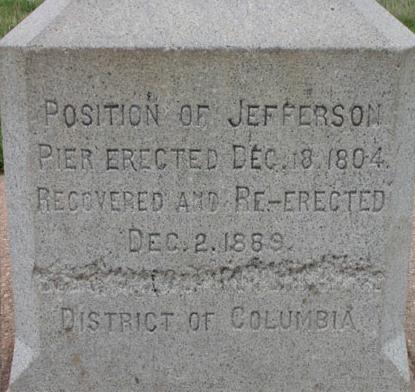
Jefferson Pier, a granite survey marker at 38°53′23″N 77°2′12″W / 38.88972°N 77.03667°W in Washington, D.C. Transcription:
|
| Date | Unknown date |
| Source | Cropped from https://web.archive.org/web/20170223132218/http://www2.nature.nps.gov/views/Sites/NAMA/Media/Images/BGs/04_WateryPast_pierstone.jpg |
| Author | National Park Service |
| Object location | | View this and other nearby images on: OpenStreetMap |
|---|
Licensing[edit]
| This image or media file contains material based on a work of a National Park Service employee, created as part of that person's official duties. As a work of the U.S. federal government, such work is in the public domain in the United States. See the NPS website and NPS copyright policy for more information. |
File history
Click on a date/time to view the file as it appeared at that time.
| Date/Time | Thumbnail | Dimensions | User | Comment | |
|---|---|---|---|---|---|
| current | 17:48, 19 April 2006 | | 415 × 392 (31 KB) | Eoghanacht (talk | contribs) | {{Information| |Description=Jefferson Pier, a granite survey marker at {{coor dms|38|53|23|N|77|2|12|W|}} in Washington, D.C. |Source= Cropt from http://www2.nature.nps.gov/views/Sites/NAMA/Media/Images/BGs/04_WateryPast_pierstone.jpg |Date=unknown |Autho |
You cannot overwrite this file.
File usage on Commons
The following 2 pages use this file:
File usage on other wikis
The following other wikis use this file:
- Usage on ceb.wikipedia.org
- Usage on en.wikipedia.org
- Usage on lt.wikipedia.org
- Usage on pt.wikipedia.org
- Usage on www.wikidata.org