File:Jarro de Valdegamas (M.A.N. Madrid) 01.jpg
Jump to navigation
Jump to search
Size of this preview: 324 × 599 pixels. Other resolutions: 130 × 240 pixels | 259 × 480 pixels | 415 × 768 pixels | 554 × 1,024 pixels | 1,413 × 2,612 pixels.
Original file (1,413 × 2,612 pixels, file size: 793 KB, MIME type: image/jpeg)
Captions
Captions
Add a one-line explanation of what this file represents
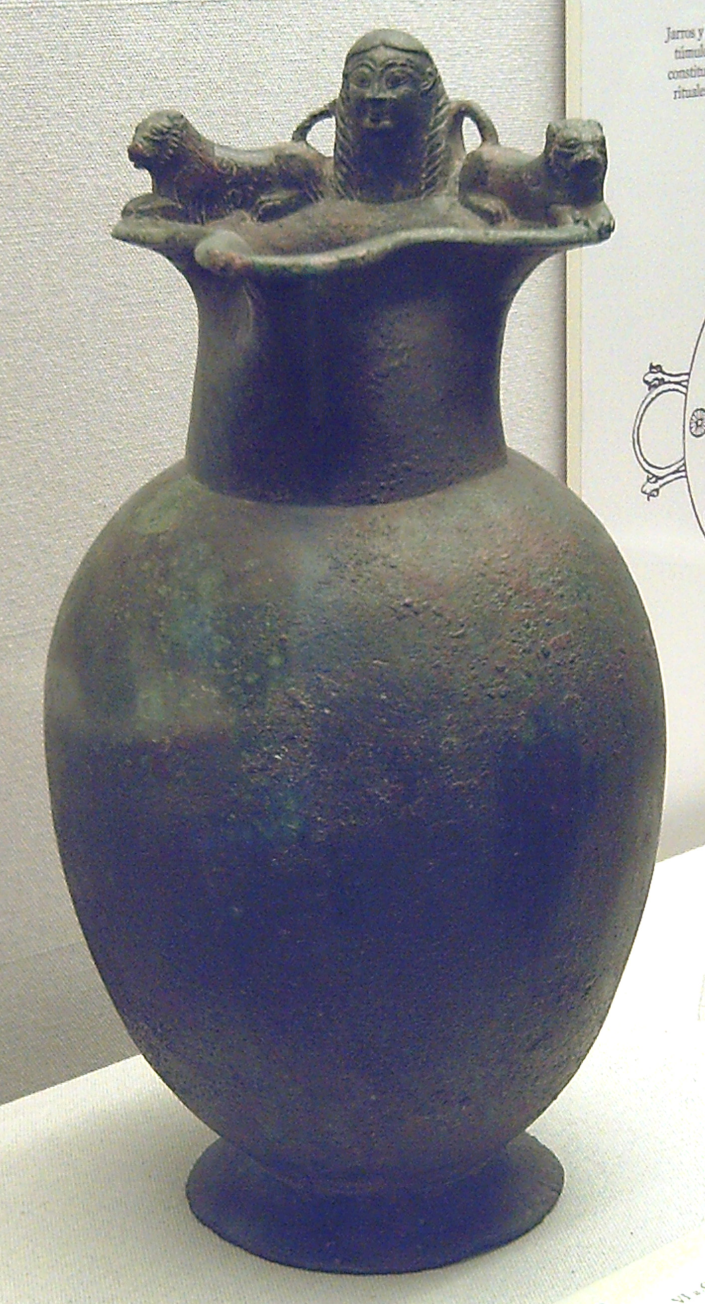
| English: Called Jar of Valdegamas.
Español: Llamado Jarro de Valdegamas. ( |
||||||||||||||||||||||||
|---|---|---|---|---|---|---|---|---|---|---|---|---|---|---|---|---|---|---|---|---|---|---|---|---|
| Title |
English: Called Jar of Valdegamas.
Español: Llamado Jarro de Valdegamas. |
|||||||||||||||||||||||
| Description |
English: Tartessian artwork.
Español: Obra tartesia. |
|||||||||||||||||||||||
| Date | between 525 and 501 BC | |||||||||||||||||||||||
| Medium | bronze | |||||||||||||||||||||||
| Dimensions | height: 29 cm (11.4 in); diameter: 25.5 cm (10 in) | |||||||||||||||||||||||
| Collection |
|
|||||||||||||||||||||||
| Accession number |
1984/80/1 |
|||||||||||||||||||||||
| Object history |
Place of discovery: Don Benito (Province of Badajoz, Spain). |
|||||||||||||||||||||||
| References | Museum's website – Web del museo | |||||||||||||||||||||||
| Source/Photographer | Flickr: Jarro de Valdegamas (M.A.N. Madrid) 01. Author: Luis García, 3 December 2008. | |||||||||||||||||||||||
| Permission (Reusing this file) |
This file is licensed under the Creative Commons Attribution-Share Alike 2.0 Generic license. Attribution: Luis García
|
|||||||||||||||||||||||
| Other versions |
 |
|||||||||||||||||||||||

| Camera location | | View this and other nearby images on: OpenStreetMap |
|---|
_01.jpg¶ms=040.423487_N_-003.689057_E_globe:Earth_type:camera__&language=en)
File history
Click on a date/time to view the file as it appeared at that time.
| Date/Time | Thumbnail | Dimensions | User | Comment | |
|---|---|---|---|---|---|
| current | 11:38, 16 November 2006 | | 1,413 × 2,612 (793 KB) | Zaqarbal (talk | contribs) | Originally posted to Flick (http://www.flickr.com/photos/zaqarbal/297675734/). Cc-by-sa-2.0. Photographer: Luis García. Date: 05-March-2006. |
You cannot overwrite this file.
File usage on Commons
The following 3 pages use this file:
_01.jpg)
_01.jpg&oldid=831864523)