File:Jan Mayen topography-fr.png
Jump to navigation
Jump to search

Size of this preview: 765 × 600 pixels. Other resolutions: 306 × 240 pixels | 612 × 480 pixels | 980 × 768 pixels | 1,280 × 1,004 pixels | 2,560 × 2,007 pixels | 3,163 × 2,480 pixels.
Original file (3,163 × 2,480 pixels, file size: 532 KB, MIME type: image/png)
Captions
Captions
Add a one-line explanation of what this file represents
| Description |
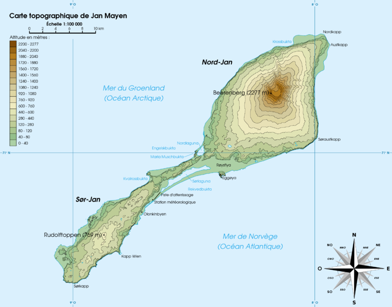
Français : Carte topographique de l'île de Jan Mayen, Norvège English: Topographic map of Jan Mayen, Norway |
||||||||
| Date | |||||||||
| Source | Own work | ||||||||
| Author | Rémih | ||||||||
| Permission (Reusing this file) |
I, the copyright holder of this work, hereby publish it under the following licenses:
You may select the license of your choice. This file is licensed under the Creative Commons Attribution-Share Alike 1.0 Generic license.
|

File history
Click on a date/time to view the file as it appeared at that time.
| Date/Time | Thumbnail | Dimensions | User | Comment | |
|---|---|---|---|---|---|
| current | 18:32, 30 April 2007 | | 3,163 × 2,480 (532 KB) | Rémih (talk | contribs) | {{Information |Description={{fr|Carte topographique de l'île de Jan Mayen, Norvège}}{{en|Topographic map of Jan Mayen, Norway}} |Source=œuvre personnelle / own work |Date=30 avril 2007 |Author=Rémih |Permission={{GFDL-self}}{{cc-by-sa} |
You cannot overwrite this file.
File usage on Commons
The following page uses this file:
File usage on other wikis
The following other wikis use this file:
- Usage on en.wikipedia.org
- Usage on fa.wikipedia.org
- Usage on fr.wikipedia.org
- Usage on hu.wikipedia.org
- Usage on ja.wikipedia.org
- Usage on nl.wikipedia.org
- Usage on pl.wikipedia.org
- Usage on sv.wikipedia.org
- Usage on www.wikidata.org