File:JR Shinjuku station track map 2010.svg
Jump to navigation
Jump to search

Size of this PNG preview of this SVG file: 800 × 308 pixels. Other resolutions: 320 × 123 pixels | 640 × 246 pixels | 1,024 × 394 pixels | 1,280 × 492 pixels | 2,560 × 985 pixels | 1,950 × 750 pixels.
Original file (SVG file, nominally 1,950 × 750 pixels, file size: 37 KB)
Captions
Captions
Add a one-line explanation of what this file represents
Summary[edit]
| Description |
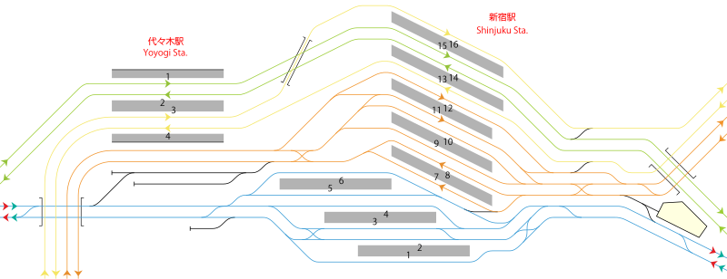
English: Plan of track map of JR Shinjuku station and Yoyogi station in Tokyo, after the completion of renovation in 2010.
日本語: JR新宿駅・代々木駅配線図。改良工事完了時(2010年)における予定。東日本旅客鉄道株式会社二十年史 p.357による。
한국어: 신주쿠 역과 요요기 역 간의 선로 지도 계획. 2010년 개량공사 완료 이후. 번역본은 File:JR Shinjuku station track map 2010 ko.svg |
| Source | Own work |
| Author | Matsukaze |
Licensing[edit]
| I, the copyright holder of this work, release this work into the public domain. This applies worldwide. In some countries this may not be legally possible; if so: I grant anyone the right to use this work for any purpose, without any conditions, unless such conditions are required by law. |
File history
Click on a date/time to view the file as it appeared at that time.
| Date/Time | Thumbnail | Dimensions | User | Comment | |
|---|---|---|---|---|---|
| current | 09:22, 6 September 2022 | 1,950 × 750 (37 KB) | Seikan Tunnel (talk | contribs) | fixed | |
| 14:29, 23 February 2010 | 1,950 × 750 (31 KB) | Araisyohei (talk | contribs) | edited svg | ||
| 14:27, 23 February 2010 | 1,950 × 750 (31 KB) | Araisyohei (talk | contribs) | edited svg | ||
| 14:01, 15 April 2009 | 1,950 × 750 (13 KB) | Matsukaze (talk | contribs) | {{Information |Description={{en|1=Plan of track map of JR Shinjuku station and Yoyogi station in Tokyo, after the completion of renovation in 2010.}} {{ja|1=JR新宿駅・代々木駅配線図。改良工事完了時(2010年)における予定。東日本 |
You cannot overwrite this file.
File usage on Commons
The following page uses this file:
File usage on other wikis
The following other wikis use this file:
- Usage on de.wikipedia.org
- Usage on en.wikipedia.org
- Usage on ja.wikipedia.org
- Usage on vi.wikipedia.org
- Usage on www.wikidata.org
- Usage on zh.wikipedia.org