File:JNA offensive plan 1991.jpg
Jump to navigation
Jump to search
Size of this preview: 582 × 600 pixels. Other resolutions: 233 × 240 pixels | 466 × 480 pixels | 651 × 671 pixels.
Original file (651 × 671 pixels, file size: 426 KB, MIME type: image/jpeg)
Captions
Captions
Add a one-line explanation of what this file represents

|
File:JNA offensive plan 1991 - ru.svg is a vector version of this file. It should be used in place of this JPG file when not inferior.
File:JNA offensive plan 1991.jpg → File:JNA offensive plan 1991 - ru.svg
For more information, see Help:SVG. |
 |

|
This map image could be re-created using vector graphics as an SVG file. This has several advantages; see Commons:Media for cleanup for more information. If an SVG form of this image is available, please upload it and afterwards replace this template with
{{vector version available|new image name}}.
It is recommended to name the SVG file “JNA offensive plan 1991.svg”—then the template Vector version available (or Vva) does not need the new image name parameter. |


Summary[edit]
| Description |
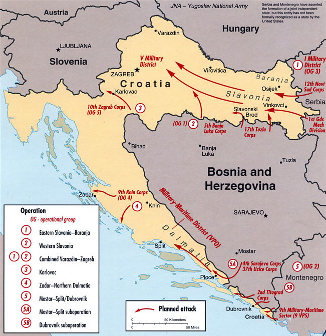
English: Strategic offensive plan of the Yugoslav People's Army in Croatia, 1991; map's caption states "DI Cartography Center 753545AI (R00446) 8-01" |
| Date | 16 January 2006 (original upload date) |
| Source | Central Intelligence Agency Office of Russian and European Analysis (2002) "Map F - JNA Strategic Offensive Plan, 1991" in Balkan Battlegrounds: A Military History of the Yugoslav Conflict, 1990–1995 Volume I, Washington, DC: Central Intelligence Agency ISBN: 9780160664724. ISBN 9780160664724 / map source: File:Kroatien - Politische Gliederung (Karte).svg by Maximilian Dörrbecker |
| Author | Central Intelligence Agency |
| Other versions |
|

.svg)
| This image is a work of a Central Intelligence Agency employee, taken or made as part of that person's official duties. As a Work of the United States Government, this image or media is in the public domain in the United States.
|

|
File history
Click on a date/time to view the file as it appeared at that time.
| Date/Time | Thumbnail | Dimensions | User | Comment | |
|---|---|---|---|---|---|
| current | 13:39, 7 February 2011 | | 651 × 671 (426 KB) | DIREKTOR (talk | contribs) | Rm border |
| 08:49, 16 January 2006 |  | 663 × 711 (140 KB) | Joonasl (talk | contribs) | Strategic offensive plan of the Yugoslav People's Army in Croatia, 1991 From "Balkan Battlegrounds", 2002. Originally from en-wiki. {{PD-USGov-CIA}} Category:Maps of Croatia |
You cannot overwrite this file.
File usage on Commons
The following 3 pages use this file:
File usage on other wikis
The following other wikis use this file:
- Usage on ar.wikipedia.org
- Usage on ast.wikipedia.org
- Usage on azb.wikipedia.org
- Usage on az.wikipedia.org
- Usage on bg.wikipedia.org
- Usage on bs.wikipedia.org
- Usage on ca.wikipedia.org
- Usage on da.wikipedia.org
- Usage on de.wikipedia.org
- Usage on en.wikipedia.org
- Usage on es.wikinews.org
- Usage on eu.wikipedia.org
- Usage on fa.wikipedia.org
- Usage on fi.wikipedia.org
- Usage on fr.wikipedia.org
- Usage on gl.wikipedia.org
- Usage on hr.wikipedia.org
- Usage on hu.wikipedia.org
- Usage on it.wikipedia.org
- Usage on ko.wikipedia.org
- Usage on lt.wikipedia.org
- Usage on no.wikipedia.org
- Usage on pt.wikipedia.org
- Usage on sh.wikipedia.org
- Usage on sv.wikipedia.org
- Usage on uk.wikipedia.org
- Usage on vi.wikipedia.org