File:Issehoved (Samsø, Danmark).JPG
Original file (4,288 × 2,848 pixels, file size: 5.42 MB, MIME type: image/jpeg)
Captions
Summary[edit]
DescriptionIssehoved (Samsø, Danmark).JPG |
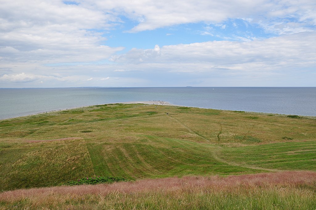
Dansk: Samsøs nordligste punkt, Issehoved, set fra Telegrafbakken. Øen Hjelm kan ses i horisonten.
Deutsch: Issehoved, der nördligste Punkt von der dänischen Insel Samsø, gesehen von Telegrafbakken aus.
English: Issehoved, the northernmost point of the Danish island of Samsø, viewed from Telegrafbakken. The coast of Mols and the small island of Hjelm can be glimpsed in the horizon. |
||||
Date | |||||
Source | Own work | ||||
Author | Bob Collowan | ||||
Permission (Reusing this file) |
|
Camera location | 55° 59′ 55.9″ N, 10° 33′ 33.16″ E | View this and other nearby images on: OpenStreetMap | 55.998860; 10.559210 |
---|
There is a discrepancy of 20 meters between the above coordinates and the ones stored at SDC (55°59′57″N 10°33′33″E, precision: 5 m). Please reconcile them. |
Licensing[edit]
- You are free:
- to share – to copy, distribute and transmit the work
- to remix – to adapt the work
- Under the following conditions:
- attribution – You must give appropriate credit, provide a link to the license, and indicate if changes were made. You may do so in any reasonable manner, but not in any way that suggests the licensor endorses you or your use.
- share alike – If you remix, transform, or build upon the material, you must distribute your contributions under the same or compatible license as the original.
This image has been assessed using the Quality image guidelines and is considered a Quality image.
العربية ∙ جازايرية ∙ беларуская ∙ беларуская (тарашкевіца) ∙ български ∙ বাংলা ∙ català ∙ čeština ∙ Cymraeg ∙ Deutsch ∙ Schweizer Hochdeutsch ∙ Zazaki ∙ Ελληνικά ∙ English ∙ Esperanto ∙ español ∙ eesti ∙ euskara ∙ فارسی ∙ suomi ∙ français ∙ galego ∙ עברית ∙ हिन्दी ∙ hrvatski ∙ magyar ∙ հայերեն ∙ Bahasa Indonesia ∙ italiano ∙ 日本語 ∙ Jawa ∙ ქართული ∙ 한국어 ∙ kurdî ∙ Lëtzebuergesch ∙ lietuvių ∙ македонски ∙ മലയാളം ∙ मराठी ∙ Bahasa Melayu ∙ Nederlands ∙ Norfuk / Pitkern ∙ polski ∙ português ∙ português do Brasil ∙ rumantsch ∙ română ∙ русский ∙ sicilianu ∙ slovenčina ∙ slovenščina ∙ shqip ∙ српски / srpski ∙ svenska ∙ தமிழ் ∙ తెలుగు ∙ ไทย ∙ Tagalog ∙ Türkçe ∙ toki pona ∙ українська ∙ vèneto ∙ Tiếng Việt ∙ 中文 ∙ 中文(简体) ∙ 中文(繁體) ∙ +/− |
Annotations InfoField | This image is annotated: View the annotations at Commons |
Hjelm
File history
Click on a date/time to view the file as it appeared at that time.
Date/Time | Thumbnail | Dimensions | User | Comment | |
---|---|---|---|---|---|
current | 11:29, 15 July 2012 | 4,288 × 2,848 (5.42 MB) | Bob Collowân (talk | contribs) |
You cannot overwrite this file.
File usage on Commons
The following 6 pages use this file:
File usage on other wikis
The following other wikis use this file:
- Usage on ceb.wikipedia.org
- Usage on da.wikipedia.org
- Usage on de.wikipedia.org
- Usage on en.wikipedia.org
- Usage on incubator.wikimedia.org
- Usage on www.wikidata.org
Metadata
This file contains additional information such as Exif metadata which may have been added by the digital camera, scanner, or software program used to create or digitize it. If the file has been modified from its original state, some details such as the timestamp may not fully reflect those of the original file. The timestamp is only as accurate as the clock in the camera, and it may be completely wrong.
Camera manufacturer | NIKON CORPORATION |
---|---|
Camera model | NIKON D90 |
Exposure time | 1/250 sec (0.004) |
F-number | f/10 |
ISO speed rating | 200 |
Date and time of data generation | 13:40, 13 July 2012 |
Lens focal length | 18 mm |
Orientation | Normal |
Horizontal resolution | 300 dpi |
Vertical resolution | 300 dpi |
Software used | Ver.1.00 |
File change date and time | 13:40, 13 July 2012 |
Y and C positioning | Co-sited |
Exposure Program | Not defined |
Exif version | 2.21 |
Date and time of digitizing | 13:40, 13 July 2012 |
Meaning of each component |
|
Image compression mode | 4 |
APEX exposure bias | 0 |
Maximum land aperture | 3.6 APEX (f/3.48) |
Metering mode | Pattern |
Light source | Unknown |
Flash | Flash did not fire, auto mode |
DateTime subseconds | 00 |
DateTimeOriginal subseconds | 00 |
DateTimeDigitized subseconds | 00 |
Supported Flashpix version | 1 |
Color space | sRGB |
Sensing method | One-chip color area sensor |
File source | Digital still camera |
Scene type | A directly photographed image |
Custom image processing | Normal process |
Exposure mode | Auto exposure |
White balance | Auto white balance |
Digital zoom ratio | 1 |
Focal length in 35 mm film | 27 mm |
Scene capture type | Landscape |
Scene control | None |
Contrast | Normal |
Saturation | Normal |
Sharpness | Normal |
Subject distance range | Unknown |
GPS tag version | 2.2.0.0 |
Structured data
Items portrayed in this file
depicts
13 July 2012
55°59'56.558"N, 10°33'33.160"E
55°59'55.90"N, 10°33'33.16"E
0.004 second
10
18 millimetre
200
image/jpeg
- Pages with local camera coordinates and mismatching SDC coordinates
- Files with coordinates missing SDC location of creation
- CC-BY-SA-3.0
- Self-published work
- Quality images
- Quality images missing SDC depicts
- Images with annotations
- Quality images of Region Midtjylland
- Denmark photographs taken on 2012-07-13
- Quality images of coasts
- Pages with maps