File:IslamicConquestsIroon-ar.png

Original file (1,006 × 893 pixels, file size: 171 KB, MIME type: image/png)
Captions
Captions
Summary[edit]
| DescriptionIslamicConquestsIroon-ar.png |
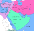
العربية: خارِطة تُظهر حُدود دولة الخِلافة الرَّاشدة والإمبراطوريتين الفارسيَّة الساسانيَّة والروميَّة البيزنطيَّة. |
| Date | |
| Source | Derivative from this file |
| Author |
|
| Other versions |
[edit]
|
| This is a retouched picture, which means that it has been digitally altered from its original version. Modifications: Translated to Arabic - عُرِّبت. The original can be viewed here: IslamicConquestsIroon.png:
|
Licensing[edit]
| Public domainPublic domainfalsefalse |
This file is in the public domain because File:Pre_Islamic_Arabia.PNG
|
File history
Click on a date/time to view the file as it appeared at that time.
| Date/Time | Thumbnail | Dimensions | User | Comment | |
|---|---|---|---|---|---|
| current | 02:59, 1 January 2016 |  | 1,006 × 893 (171 KB) | AzizQ8 (talk | contribs) | Reverted to version as of 21:09, 21 September 2014 (UTC) |
| 13:13, 1 December 2015 |  | 1,002 × 895 (177 KB) | Alborzagros (talk | contribs) | There was no name like basra gulf in 630 AC. Please read the article Basra. ((The present city was founded in 636 as an encampment and garrison for Arab tribesmen constituting the armies of the Rashidun Caliph Umar a few kilometres south of the present... | |
| 21:09, 21 September 2014 |  | 1,006 × 893 (171 KB) | باسم (talk | contribs) | User created page with UploadWizard |
You cannot overwrite this file.
File usage on Commons
The following 4 pages use this file:
File usage on other wikis
The following other wikis use this file:
- Usage on ar.wikipedia.org
- Usage on ary.wikipedia.org
- Usage on fa.wikipedia.org
Metadata
This file contains additional information such as Exif metadata which may have been added by the digital camera, scanner, or software program used to create or digitize it. If the file has been modified from its original state, some details such as the timestamp may not fully reflect those of the original file. The timestamp is only as accurate as the clock in the camera, and it may be completely wrong.
| Horizontal resolution | 35.43 dpc |
|---|---|
| Vertical resolution | 35.43 dpc |
| Software used |


