File:Iron ore Pilbara.jpg
Jump to navigation
Jump to search

Size of this preview: 800 × 586 pixels. Other resolutions: 320 × 234 pixels | 640 × 469 pixels | 1,024 × 750 pixels | 1,280 × 938 pixels | 2,048 × 1,500 pixels.
Original file (2,048 × 1,500 pixels, file size: 268 KB, MIME type: image/jpeg)
Captions
Captions
Add a one-line explanation of what this file represents

|
File:Iron ore Pilbara 2.svg is a vector version of this file. It should be used in place of this JPG file when not inferior.
File:Iron ore Pilbara.jpg → File:Iron ore Pilbara 2.svg
For more information, see Help:SVG. |
 |
Summary[edit]
| Description |
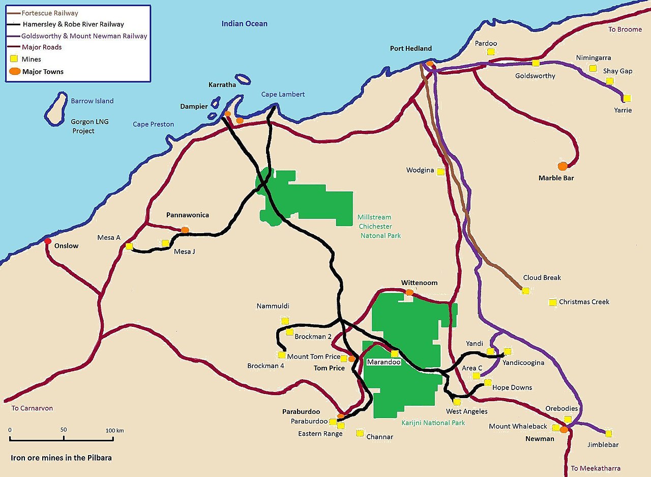
English: Map of the iron ore mines & railways in the Pilbara region of Western Australia. |
| Date | |
| Source | Own work |
| Author | Calistemon |
Licensing[edit]
I, the copyright holder of this work, hereby publish it under the following licenses:
This file is licensed under the Creative Commons Attribution-Share Alike 3.0 Unported license.
- You are free:
- to share – to copy, distribute and transmit the work
- to remix – to adapt the work
- Under the following conditions:
- attribution – You must give appropriate credit, provide a link to the license, and indicate if changes were made. You may do so in any reasonable manner, but not in any way that suggests the licensor endorses you or your use.
- share alike – If you remix, transform, or build upon the material, you must distribute your contributions under the same or compatible license as the original.

|
Permission is granted to copy, distribute and/or modify this document under the terms of the GNU Free Documentation License, Version 1.2 or any later version published by the Free Software Foundation; with no Invariant Sections, no Front-Cover Texts, and no Back-Cover Texts. A copy of the license is included in the section entitled GNU Free Documentation License. |
You may select the license of your choice.
File history
Click on a date/time to view the file as it appeared at that time.
| Date/Time | Thumbnail | Dimensions | User | Comment | |
|---|---|---|---|---|---|
| current | 07:59, 7 December 2010 | | 2,048 × 1,500 (268 KB) | Calistemon (talk | contribs) | Colored in ocean. |
| 07:32, 7 December 2010 |  | 2,048 × 1,500 (266 KB) | Calistemon (talk | contribs) | Town names in bold and black. | |
| 07:14, 7 December 2010 |  | 2,048 × 1,500 (264 KB) | Calistemon (talk | contribs) | Coloring in of land mass, as done by User:Gnangarra. | |
| 02:03, 7 December 2010 |  | 2,048 × 1,500 (263 KB) | Calistemon (talk | contribs) | Fixed spelling mistake. | |
| 01:54, 7 December 2010 |  | 2,048 × 1,500 (266 KB) | Calistemon (talk | contribs) | Add barrow Island, Gorgon, the Sino project and Western Turner. | |
| 01:34, 7 December 2010 |  | 2,048 × 1,500 (257 KB) | Calistemon (talk | contribs) | Increased size of writing. | |
| 02:18, 5 December 2010 |  | 2,048 × 1,500 (238 KB) | Calistemon (talk | contribs) | Clean up map, add some more locations. | |
| 15:05, 4 December 2010 |  | 2,048 × 1,500 (235 KB) | Calistemon (talk | contribs) | Added missing Mount Tom Price mine, removed section of road thats not a major road. | |
| 14:40, 4 December 2010 |  | 2,048 × 1,500 (234 KB) | Calistemon (talk | contribs) | {{Information |Description={{en|1=Map of the iron ore mines in the Pilbara region of Western Australia.}} |Source={{own}} |Author=Calistemon |Date=2010-12-04 |Permission= |other_versions= }} |
You cannot overwrite this file.
File usage on Commons
There are no pages that use this file.
File usage on other wikis
The following other wikis use this file:
- Usage on en.wikipedia.org