File:Iro Lake, south of Chade, Africa.jpg
Jump to navigation
Jump to search
Size of this preview: 800 × 452 pixels. Other resolutions: 320 × 181 pixels | 640 × 362 pixels | 1,024 × 579 pixels | 1,280 × 723 pixels | 2,560 × 1,447 pixels | 4,032 × 2,279 pixels.
Original file (4,032 × 2,279 pixels, file size: 4.58 MB, MIME type: image/jpeg)
Captions
Captions
Add a one-line explanation of what this file represents
Summary[edit]
| Description |
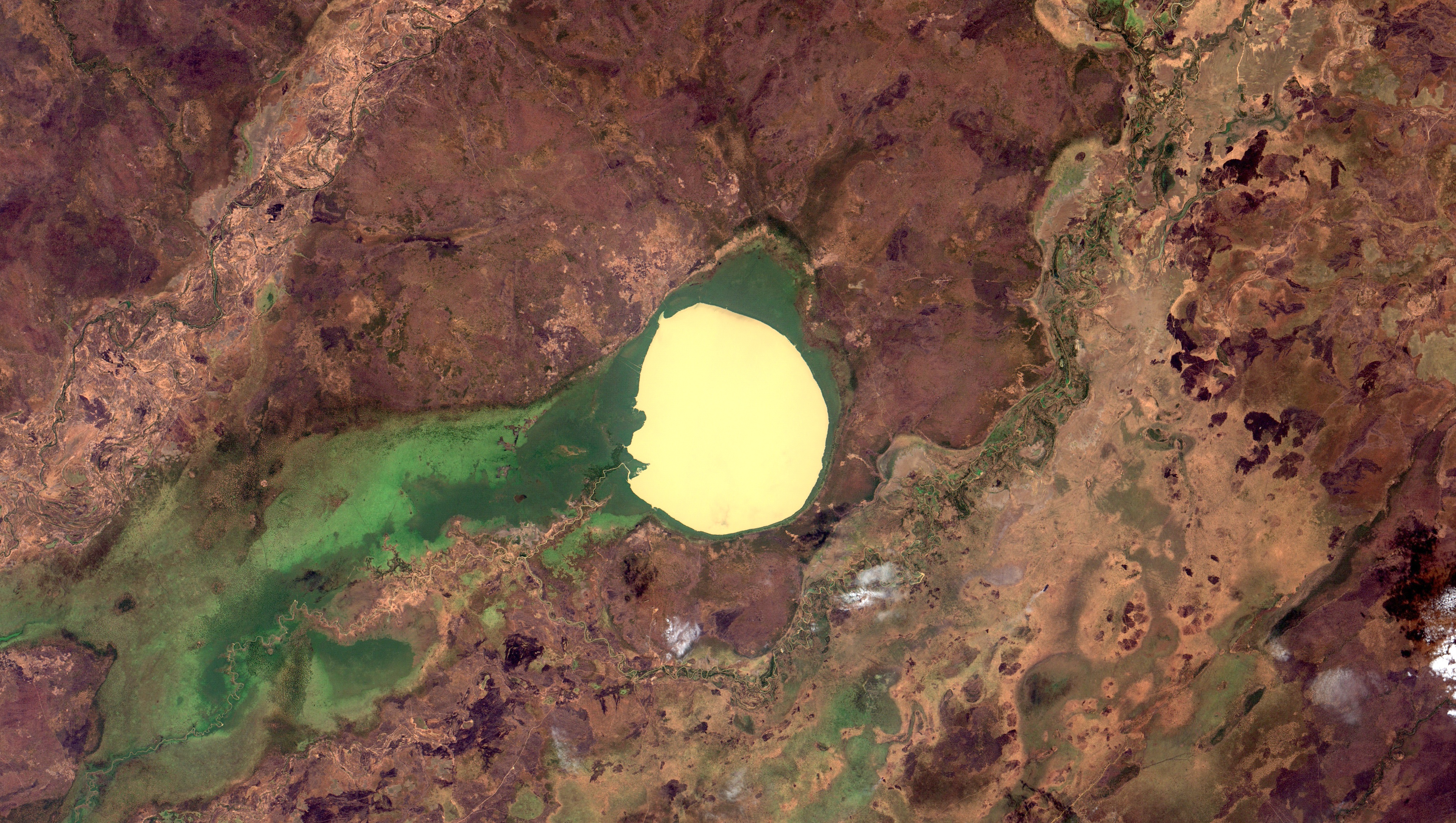
English: Lago Iro no Sul do Chade. Com cerca de 100 km2 quando está cheio, como nessa imagem de anteontem, é um lago efêmero em bacia de drenagem endorréica, que seca completamente durante grandes estiagens. Com baixo impacto humano, é importante economicamente por produzir em torno de 1000 toneladas de peixe por ano, além da importância para a vida selvagem como local de reprodução para várias espécies de aves aquáticas migratórias e viveiro para várias espécies de peixes. Em amarelo claro, superfície da água. Em verde escuro, macrófitas. Em marrom, savana tropical. O Lago Iro é listado como possível astroblema (cratera de impacto de asteróide) / Southern Chad Lake Iro. With around 39 mi2 when full, like in this 2 days old image, it´s an ephemeral lake at an endorreic drainage basin, drying completly on long droughts. Producing around 1000 fish tons per year, it´s economically important, besides playing a very important role for the surrounding wildlife, providing breeding sites for several species of migratory waterfowl and being a nursery for several families of fish. In light yellow, water surface. In dark green, macrophytes. In brown, tropical savannas. Lake Iro is listed as a possible impact crater.
Imagem / Image CBERS4 MUX Lago Iro, sul do Chade, Africa / Iro Lake, south of Chade, Africa Coordenadas do centro da imagem / Image center: 10°06'18.4"N 19°25'33.0"E Data / Date: 09-12-2018 / 2018-09-12 RGB 765 (cor verdadeira / true color) Cena / Scene: 094/ 089 Autor / Author: Oton Barros (DSR/OBT/INPE) Imagem em HD / HD Image Visite-nos / Visit us: www.dsr.inpe.br |
| Date | |
| Source | https://www.flickr.com/photos/153282474@N02/46235585892/ |
| Author | Coordenação-Geral de Observação da Terra/INPE |
Licensing[edit]
This file is licensed under the Creative Commons Attribution-Share Alike 2.0 Generic license.
- You are free:
- to share – to copy, distribute and transmit the work
- to remix – to adapt the work
- Under the following conditions:
- attribution – You must give appropriate credit, provide a link to the license, and indicate if changes were made. You may do so in any reasonable manner, but not in any way that suggests the licensor endorses you or your use.
- share alike – If you remix, transform, or build upon the material, you must distribute your contributions under the same or compatible license as the original.
| This image was originally posted to Flickr by Coordenação-Geral de Observação da Terra/INPE at https://flickr.com/photos/153282474@N02/46235585892. It was reviewed on 9 April 2020 by FlickreviewR 2 and was confirmed to be licensed under the terms of the cc-by-sa-2.0. |
File history
Click on a date/time to view the file as it appeared at that time.
| Date/Time | Thumbnail | Dimensions | User | Comment | |
|---|---|---|---|---|---|
| current | 10:14, 9 April 2020 | | 4,032 × 2,279 (4.58 MB) | Jo-Jo Eumerus (talk | contribs) | Uploaded a work by Coordenação-Geral de Observação da Terra/INPE from https://www.flickr.com/photos/153282474@N02/46235585892/ with UploadWizard |
You cannot overwrite this file.
File usage on Commons
The following 2 pages use this file:
.jpg&redirect=no)