File:Informative notice on construction site - geograph.org.uk - 1497852.jpg
Informative_notice_on_construction_site_-_geograph.org.uk_-_1497852.jpg (640 × 427 pixels, file size: 148 KB, MIME type: image/jpeg)
Captions
Captions
Summary[edit]
| DescriptionInformative notice on construction site - geograph.org.uk - 1497852.jpg |
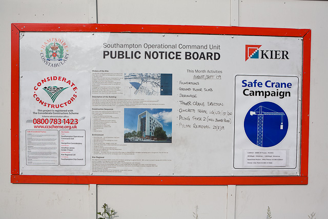
English: Informative notice on construction site This joint notice by construction firm Kier Regional Ltd and clients Hampshire Constabulary, tells the public about the history of the site, the planned sequence of building operations, and what is going on at the time. The map shows the location of WWII bomb craters and a suspected UXB requiring to be investigated before piling could begin.
"History of the site The site was initially developed from mud flats of the River Test in the 1950s to facilitate the construction of Southern Road. By the 1960s the site had been developed for use as a depot, involving the construction of warehouse buildings to the north east boundary. The electricity pylons were installed in the 1970s. These 132 KV lines supply power to over 80% of Southampton. Investigations have led to confim there may be a possible risk of unexploded ordnance from WWII. As a result specialists have carried out magnetometer surveying in the area. Description of the building The contract is to build the new facilities for Hampshire Constabulary to move into in 2010. There will be an 8 storey office tower and a custody suite with 36 cells. The reinforced concrete frame will be clad with stone, curtain walling and brickwork. The project commences in May 2009 and completes in December 2010." The Safe Crane Campaign notice says that the crane is a Lierherr 200EC-B tower capable of lifting 9530 Kg at 20 metres, and names the person responsible for it. |
| Date | |
| Source | From geograph.org.uk |
| Author | Peter Facey |
| Attribution (required by the license) InfoField | Peter Facey / Informative notice on construction site / |
InfoField | Peter Facey / Informative notice on construction site |
| Camera location | 50° 54′ 20.8″ N, 1° 24′ 58″ W | View this and other nearby images on: OpenStreetMap |
|---|
| Object location | 50° 54′ 20.8″ N, 1° 24′ 58″ W | View this and other nearby images on: OpenStreetMap |
|---|
Licensing[edit]

|
This image was taken from the Geograph project collection. See this photograph's page on the Geograph website for the photographer's contact details. The copyright on this image is owned by Peter Facey and is licensed for reuse under the Creative Commons Attribution-ShareAlike 2.0 license.
|
- You are free:
- to share – to copy, distribute and transmit the work
- to remix – to adapt the work
- Under the following conditions:
- attribution – You must give appropriate credit, provide a link to the license, and indicate if changes were made. You may do so in any reasonable manner, but not in any way that suggests the licensor endorses you or your use.
- share alike – If you remix, transform, or build upon the material, you must distribute your contributions under the same or compatible license as the original.
File history
Click on a date/time to view the file as it appeared at that time.
| Date/Time | Thumbnail | Dimensions | User | Comment | |
|---|---|---|---|---|---|
| current | 17:31, 2 March 2011 |  | 640 × 427 (148 KB) | GeographBot (talk | contribs) | == {{int:filedesc}} == {{Information |description={{en|1=Informative notice on construction site This joint notice by construction firm Kier Regional Ltd and clients Hampshire Constabulary, tells the public about the history of the site, the planned seque |
You cannot overwrite this file.
File usage on Commons
There are no pages that use this file.
Metadata
This file contains additional information such as Exif metadata which may have been added by the digital camera, scanner, or software program used to create or digitize it. If the file has been modified from its original state, some details such as the timestamp may not fully reflect those of the original file. The timestamp is only as accurate as the clock in the camera, and it may be completely wrong.
| Camera manufacturer | Canon |
|---|---|
| Camera model | Canon EOS 5D |
| Copyright holder | Copyright 2009 Peter V. Facey |
| Exposure time | 1/2,500 sec (0.0004) |
| F-number | f/7.1 |
| ISO speed rating | 200 |
| Date and time of data generation | 10:48, 20 September 2009 |
| Lens focal length | 32 mm |
| Horizontal resolution | 72 dpi |
| Vertical resolution | 72 dpi |
| File change date and time | 17:43, 20 September 2009 |
| Exposure Program | Aperture priority |
| Exif version | 2.21 |
| Date and time of digitizing | 10:48, 20 September 2009 |
| APEX shutter speed | 11.287712 |
| APEX aperture | 5.655638 |
| APEX exposure bias | 0 |
| Maximum land aperture | 3 APEX (f/2.83) |
| Metering mode | Unknown |
| Flash | Flash did not fire, compulsory flash suppression |
| Focal plane X resolution | 3,086.925795053 |
| Focal plane Y resolution | 3,091.2951167728 |
| Focal plane resolution unit | inches |
| Custom image processing | Normal process |
| Exposure mode | Auto exposure |
| White balance | Auto white balance |
| Scene capture type | Standard |
