File:India Uttar Pradesh districts numbered.svg
Jump to navigation
Jump to search

Size of this PNG preview of this SVG file: 578 × 599 pixels. Other resolutions: 232 × 240 pixels | 463 × 480 pixels | 741 × 768 pixels | 988 × 1,024 pixels | 1,976 × 2,048 pixels | 2,379 × 2,466 pixels.
Original file (SVG file, nominally 2,379 × 2,466 pixels, file size: 157 KB)
Captions
Captions
Add a one-line explanation of what this file represents
| Description |
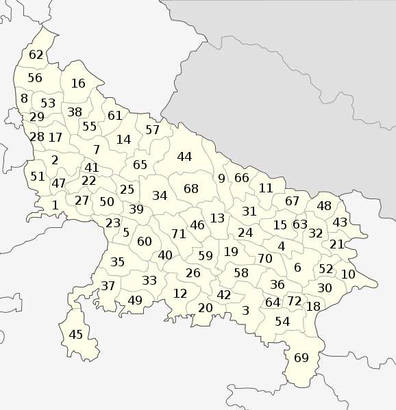
English: Locator map of the districts of Uttar Pradesh, India (numbered). Based on File:Uttar Pradesh locator map.svg
Districts:
|
| Date | |
| Source | |
| Author |
|
| Other versions | File:India Uttar Pradesh districts.svg |
I, the copyright holder of this work, hereby publish it under the following license:
| |
This work has been released into the public domain by its author, Example, at the [[::|English Wikipedia]] project. This applies worldwide. In case this is not legally possible: |
Original upload log[edit]
This image is a derivative work of the following images:
- File:Uttar_Pradesh_locator_map.svg licensed with PD-user-w
- 2009-11-05T21:34:09Z File Upload Bot (Magnus Manske) 2400x2515 (140024 Bytes) {{BotMoveToCommons|en.wikipedia|year={{subst:CURRENTYEAR}}|month={{subst:CURRENTMONTHNAME}}|day={{subst:CURRENTDAY}}}} {{Information |Description={{en|This map has been created by [[:en:User:Faizhaider|Faiz Haider]], it is b
File history
Click on a date/time to view the file as it appeared at that time.
| Date/Time | Thumbnail | Dimensions | User | Comment | |
|---|---|---|---|---|---|
| current | 17:46, 25 December 2010 | | 2,379 × 2,466 (157 KB) | BishkekRocks (talk | contribs) | Unnao: 72 > 71 |
| 15:04, 19 December 2010 |  | 2,379 × 2,466 (157 KB) | BishkekRocks (talk | contribs) | fix position of numbers 28 & 29 | |
| 13:22, 12 December 2010 |  | 2,379 × 2,466 (157 KB) | BishkekRocks (talk | contribs) | {{Information |Description={{en|Locator map of the districts of Uttar Pradesh, India (numbered). Based on File:Uttar Pradesh locator map.svg Districts: # Agra # Aligarh # Allahabad # Ambedkar Nagar # Auraiya # Azamgarh # Badaun # Baghpat # Bahraich |
You cannot overwrite this file.
File usage on Commons
There are no pages that use this file.