File:Image-Arnhem Land topographic sketch.jpg
Jump to navigation
Jump to search
Size of this preview: 800 × 556 pixels. Other resolutions: 320 × 222 pixels | 640 × 445 pixels | 1,024 × 712 pixels | 1,280 × 889 pixels | 2,438 × 1,694 pixels.
Original file (2,438 × 1,694 pixels, file size: 363 KB, MIME type: image/jpeg)
Captions
Captions
Add a one-line explanation of what this file represents
Summary[edit]
| Description |
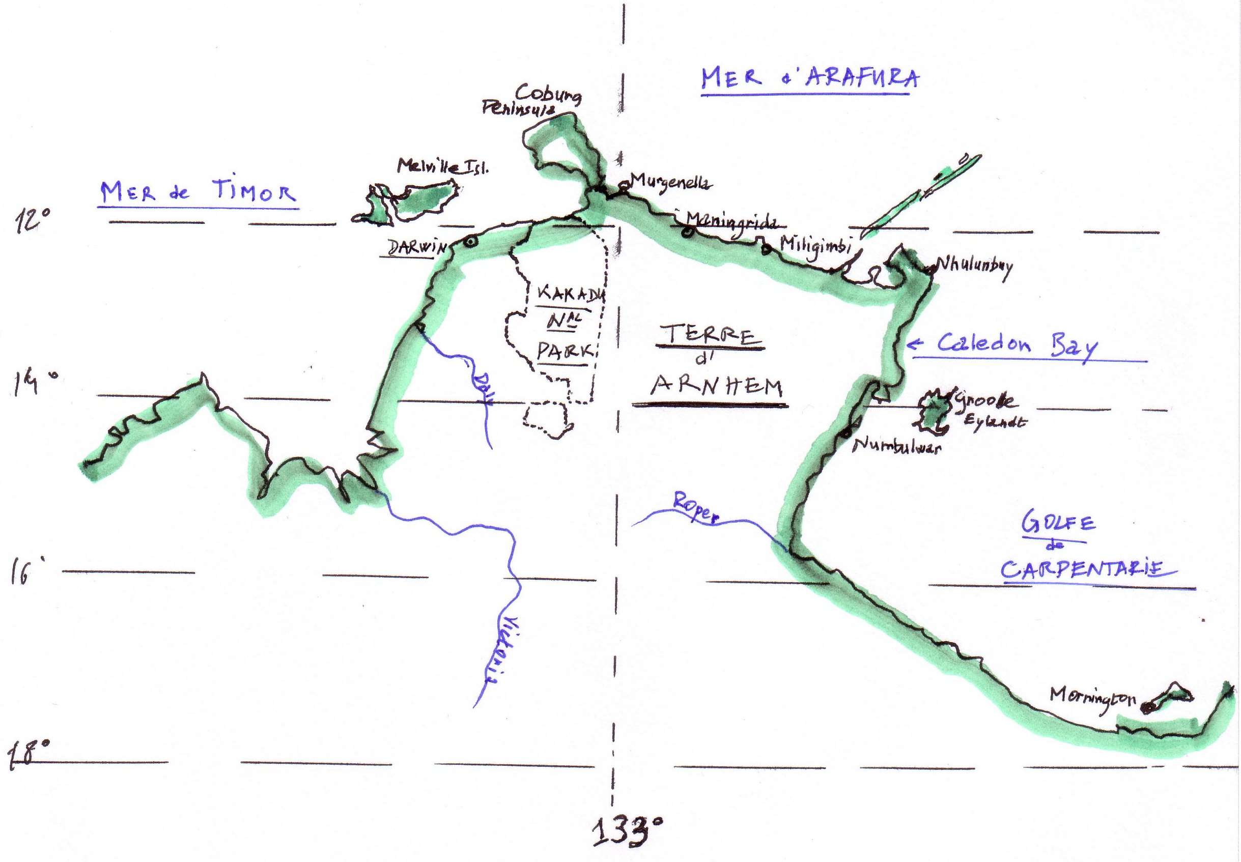
English: Topographic sketch of Arnhem Land (Northern Territories, Australia). Note the indigenous, dutch, and english toponymy.
Français : Schéma topographique de la Terre d'Arnhem (Territoires du Nord, Australie). Noter la toponymie d'origine à la fois indigène, hollandaise, et anglaise. |
| Date | |
| Source | travail personnel (own work) d'aprés atlas |
| Author | Arapaima |
Sont indiqués : les localités de Maningrida (centre culturel aborigène vivace), prés de la côte de la Mer d'Arafura - le célèbre Parc National de Kakadu - et la Baie Caledon (sur le Golfe de Carpentarie), qui fut en 1932-33 le foyer d'un mouvement insurrectionnel des Indigènes Australiens, resté dans l'histoire australienne sous le nom de Caledon Bay Crisis.
Licensing[edit]
I, the copyright holder of this work, hereby publish it under the following licenses:

|
Permission is granted to copy, distribute and/or modify this document under the terms of the GNU Free Documentation License, Version 1.2 or any later version published by the Free Software Foundation; with no Invariant Sections, no Front-Cover Texts, and no Back-Cover Texts. A copy of the license is included in the section entitled GNU Free Documentation License. |
This file is licensed under the Creative Commons Attribution-Share Alike 3.0 Unported, 2.5 Generic, 2.0 Generic and 1.0 Generic license.
- You are free:
- to share – to copy, distribute and transmit the work
- to remix – to adapt the work
- Under the following conditions:
- attribution – You must give appropriate credit, provide a link to the license, and indicate if changes were made. You may do so in any reasonable manner, but not in any way that suggests the licensor endorses you or your use.
- share alike – If you remix, transform, or build upon the material, you must distribute your contributions under the same or compatible license as the original.
You may select the license of your choice.
File history
Click on a date/time to view the file as it appeared at that time.
| Date/Time | Thumbnail | Dimensions | User | Comment | |
|---|---|---|---|---|---|
| current | 12:23, 1 February 2009 | | 2,438 × 1,694 (363 KB) | Cæruleum (talk | contribs) | {{en}} cropped image. {{fr}} retrait du cadre blanc. |
| 09:39, 15 January 2009 |  | 2,552 × 3,508 (392 KB) | Arapaima (talk | contribs) | {{Information |Description={{en|1=Topographic sketch of Arnhem Land (Northern Territories, Australia). Note the indigenous, dutch, and english toponymy.}} {{fr|1=Schéma topographique de la Terre d'Arnhem (Territoires du Nord, Australie). Noter la toponym |
You cannot overwrite this file.
File usage on Commons
There are no pages that use this file.
File usage on other wikis
The following other wikis use this file:
- Usage on fr.wikipedia.org