File:Iceberg from Pine Island Glacier, Antarctica - November 21, 2013.jpg

Original file (1,400 × 1,800 pixels, file size: 250 KB, MIME type: image/jpeg)
Captions
Captions
| Description |
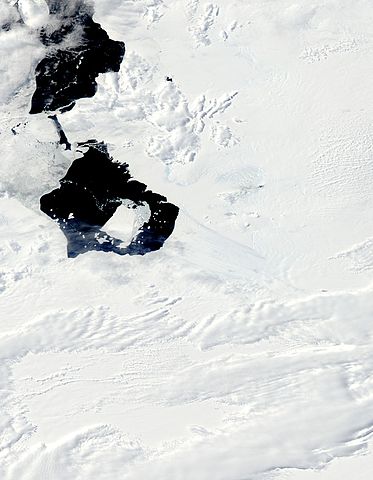
As late spring in Antarctica brings relatively warmer days, snow and ice begins to retreat – and free-floating icebergs are on the move. On November 21, 2013 the Moderate Resolution Imaging Spectroradiometer (MODIS) aboard NASA’s Aqua satellite captured this true-color image of the newly calved Iceberg B-31 drifting away from its recent connection with Pine Island Glacier. The original rift in the Pine Island Glacier that formed the iceberg was observed as early as October 2011, but as the disconnection was not complete. It is believed the physical separation took place on or about July 10, 2013, however the iceberg remained butted against the glacier. Between November 9-10 the rift began to widen, and Iceberg B-31 was officially “born”. The iceberg is estimated to be 21 miles by 12 miles (35 km by 20 km) in size, roughly the size of Singapore, and about 50% larger than previous icebergs in this area. On November 29 the U.S. National Ice Center reported the location of B-31 to be 74°53'S latitude 103°26'W longitude. The Pine Island Glacier is one of the largest and fastest-moving glaciers in Antarctica. According to the US Geological Survey, Earth Resources Observation and Science Center (USGS EROS), satellite measurements have shown that the Pine Island Glacier Basin has a greater net contribution of ice to the sea than any other ice drainage basin in the world. |
|||||
| Date | ||||||
| Source | Iceberg from Pine Island Glacier, Antarctica | |||||
| Author |
Jeff Schmaltz MODIS Land Rapid Response Team, NASA GSFC |
|||||
| Permission (Reusing this file) |
|

File history
Click on a date/time to view the file as it appeared at that time.
| Date/Time | Thumbnail | Dimensions | User | Comment | |
|---|---|---|---|---|---|
| current | 12:15, 6 December 2013 | | 1,400 × 1,800 (250 KB) | DarwIn (talk | contribs) | {{Information |Description= As late spring in Antarctica brings relatively warmer days, snow and ice begins to retreat – and free-floating icebergs are on the move. On November 21, 2013 the Moderate Resolution Imaging Spectroradiometer (MODIS) aboard... |
You cannot overwrite this file.
File usage on Commons
The following 2 pages use this file: