File:Iceberg from Pine Island Glacier, Antarctica (MODIS 2015-09-16).jpg

Original file (1,800 × 1,400 pixels, file size: 336 KB, MIME type: image/jpeg)
Captions
Captions
Summary[edit]
.jpg&action=edit§ion=1)
| Description |
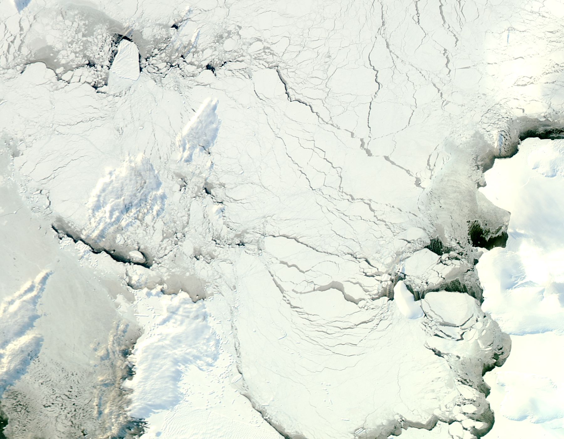
English: As temperatures begin to slowly rise as springtime approaches in Antarctica, icebergs begin to shift positions in the moving sea ice, and new icebergs are born.
On August 11, 2015, the U.S. National Ice Center reported a new iceberg had calved from the Pine Island Glacier in Pine Island Bay. The new-born iceberg was named B-35 and measured about 12.66 miles (20.4 km) long by 8 miles (12.8 km) wide. It was located in the Amundsen Sea at 74�41�36� South, 103�53�12, still near the calving front of Pine Island Glacier. This location would be near the lower right corner of this image. The last large iceberg calved off of Pine Island Glacier was B-31, which was calved in early August 2013. B-31 remains located within the Amundsen Sea, at 71�53� South, 112�44� West, near the upper left of this image. B-31 has traveled nearly 282 miles (484 km) since its birth over 2 years ago. The Moderate Resolution Imaging Spectroradiometer (MODIS) aboard NASA�s Aqua satellite captured this true-color image of various icebergs in Pine Island Bay on September 9, 2015. While icebergs are numerous in the Antarctic, not all icebergs are named. Only those that measure at least 12 mi (19 km) are named and tracked by the U.S. National Ice Center. Iceberg names come from the quadrant in the Antarctic in which they were originally sighted. Iceberg names beginning with B are those which were first seen in the Amundsen/Eastern Ross Sea (90 W to 180). The number in the name represents the sequential number of the iceberg tracked, so B-31 was the thirty-first iceberg tracked between 90W and 180, and B-35 was the thirty-fifth iceberg tracked. |
||
| Date | Taken on 5 September 2015 | ||
| Source |
Iceberg from Pine Island Glacier, Antarctica (direct link)
|
||
| Author | Jeff Schmaltz, MODIS Land Rapid Response Team, NASA GSFC |
| This media is a product of the Aqua mission Credit and attribution belongs to the mission team, if not already specified in the "author" row |
Licensing[edit]
.jpg&action=edit§ion=2)
| This file is in the public domain in the United States because it was solely created by NASA. NASA copyright policy states that "NASA material is not protected by copyright unless noted". (See Template:PD-USGov, NASA copyright policy page or JPL Image Use Policy.) | ||
 |
Warnings:
|
File history
Click on a date/time to view the file as it appeared at that time.
| Date/Time | Thumbnail | Dimensions | User | Comment | |
|---|---|---|---|---|---|
| current | 09:57, 15 February 2024 | | 1,800 × 1,400 (336 KB) | OptimusPrimeBot (talk | contribs) | #Spacemedia - Upload of http://modis.gsfc.nasa.gov/gallery/images/image09162015_250m.jpg via Commons:Spacemedia |
You cannot overwrite this file.
File usage on Commons
There are no pages that use this file.
.jpg&oldid=851932865)