File:Ibèria el 300 aC.svg
Jump to navigation
Jump to search

Size of this PNG preview of this SVG file: 727 × 600 pixels. Other resolutions: 291 × 240 pixels | 582 × 480 pixels | 931 × 768 pixels | 1,242 × 1,024 pixels | 2,484 × 2,048 pixels | 924 × 762 pixels.
Original file (SVG file, nominally 924 × 762 pixels, file size: 769 KB)
Captions
Captions
Add a one-line explanation of what this file represents
Summary[edit]
| Description |
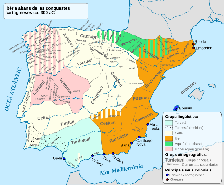
English: Ethnographic and Linguistic Map of the Iberian Peninsula at about 300 BCE (before the Carthaginian conquests).
Català: Mapa etnogràfic i lingüístic de la península Ibèrica als voltants del 300 aC (abans de les conquestes cartagineses). |
| Date | (UTC) |
| Source |
This file was derived from: Iberia 300BC-en.svg: |
| Author |
|
| This is a retouched picture, which means that it has been digitally altered from its original version. Modifications: translated to Catalan. The original can be viewed here: Iberia 300BC-en.svg:
|
Licensing[edit]
I, the copyright holder of this work, hereby publish it under the following license:

|
Permission is granted to copy, distribute and/or modify this document under the terms of the GNU Free Documentation License, Version 1.2 or any later version published by the Free Software Foundation; with no Invariant Sections, no Front-Cover Texts, and no Back-Cover Texts. A copy of the license is included in the section entitled GNU Free Documentation License. |
Original upload log[edit]
This image is a derivative work of the following images:
- File:Iberia_300BC.svg licensed with GFDL
- 2012-04-08T15:45:43Z Kordas 924x762 (824645 Bytes) Fixing Formentera color and showing mixed area in Oretania
- 2012-04-08T03:42:22Z Kordas 924x762 (501307 Bytes) See file talk
- 2010-04-26T23:03:42Z Alcides Pinto 924x762 (333627 Bytes) Solve upload problem
- 2010-04-26T22:54:41Z Alcides Pinto 924x762 (334099 Bytes) {{Information |Description={{en|1=Ethnographic and Linguistic Map of the Iberian Peninsula at about 300 BCE (before the Carthaginian conquests).}} |Source=Based on the map done by Portuguese Archeologist Luís Fraga, from the
Uploaded with derivativeFX
File history
Click on a date/time to view the file as it appeared at that time.
| Date/Time | Thumbnail | Dimensions | User | Comment | |
|---|---|---|---|---|---|
| current | 16:53, 2 August 2012 | | 924 × 762 (769 KB) | Arnaugir (talk | contribs) | == {{int:filedesc}} == {{Information |Description={{en|1=Ethnographic and Linguistic Map of the Iberian Peninsula at about 300 BCE (before the Carthaginian conquests).}} {{ca|1=Mapa etnogràfic i lingüístic de la península Ibèrica als voltants del ... |
You cannot overwrite this file.
File usage on Commons
The following page uses this file:
File usage on other wikis
The following other wikis use this file:
- Usage on ca.wikipedia.org
- Usage on es.wikipedia.org