File:ISS034-E-005935 Liège Aachen Verniers area at night.jpg

From Wikimedia Commons, the free media repository
Jump to navigation Jump to search

Original file(4,256 × 2,738 pixels, file size: 6.81 MB, MIME type: image/jpeg)

Captions

Captions

Add a one-line explanation of what this file represents

Summary[edit]

Description
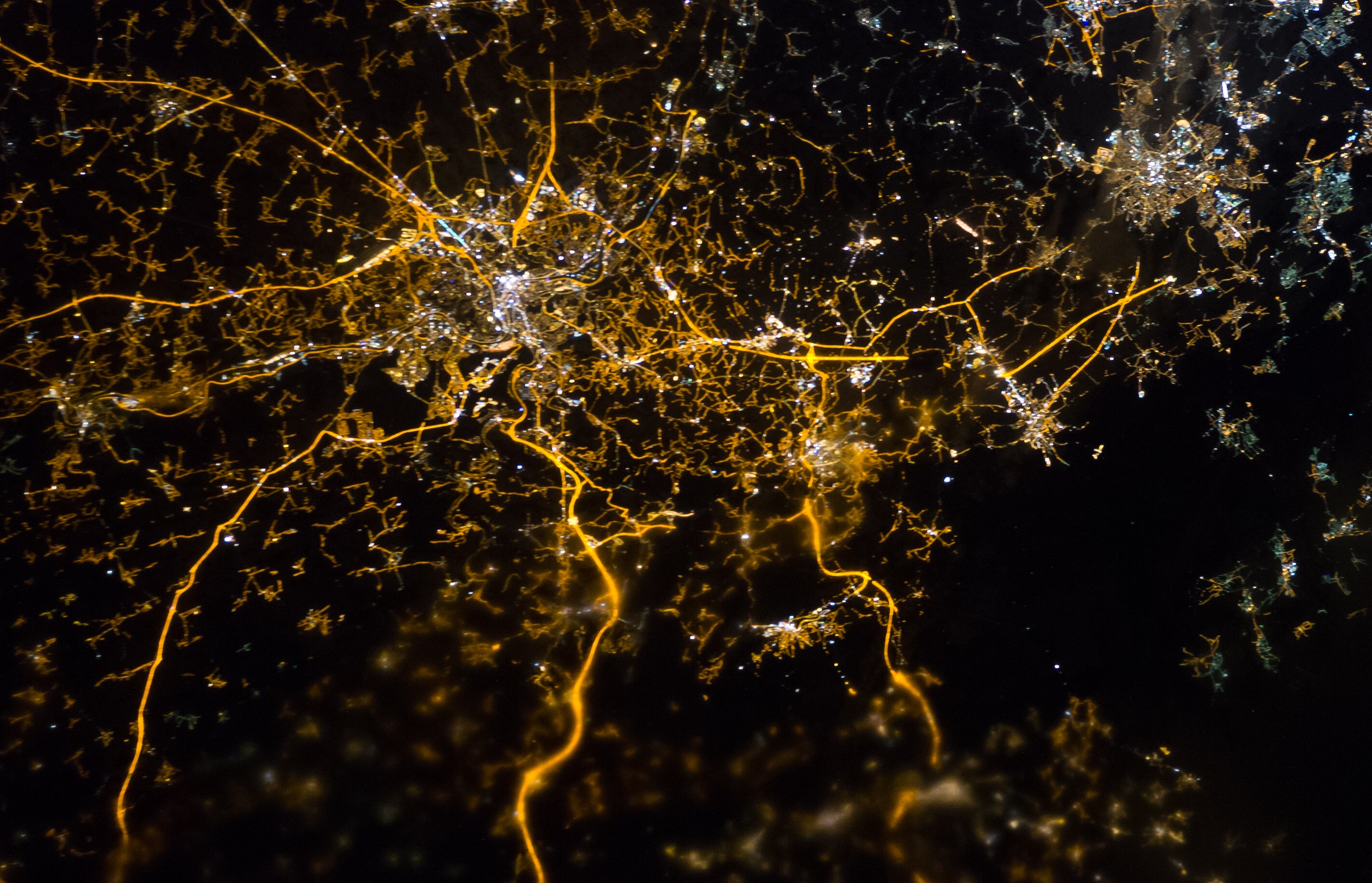
English: The brightly lit core of the Liège urban area appears to lie at the center of a network of roadways—traceable by continuous orange lighting—extending outwards into the rural, and relatively dark, Belgium countryside; Liège is on the left, Aachen on the right. Between the two, Verviers (left) and Eupen (right). The city of Spa is a bit lower, nearby the Hautes Fagnes protected area (no light)


International Space Station InsigniaISS Crew Earth Observations: ISS034-E-005935International Space Station Insignia
Identification
Mission ISS034 (Expedition 34)
Roll E
Frame 005935
Country or Geographic Name BELGIUM
Features ESA NIGHTPOD - LIEGE-AACHEN-VERNIERS AREA AT NIGHT
Center Point Latitude 50.6° N
Center Point Longitude 5.8° E
Camera
Camera Tilt 39°
Camera Focal Length 180 mm
Camera Nikon D3S
Film 4256 x 2832 pixel CMOS sensor, 36.0mm x 23.9mm, total pixels: 12.87 million, Nikon FX format.
Quality
Percentage of Cloud Cover 0-10%
Nadir What is Nadir?
Date 2012-12-08
Time 21:39:11
Nadir Point Latitude 51.2° N
Nadir Point Longitude 8.6° E
Nadir to Photo Center Direction West
Sun Azimuth 317°
Spacecraft Altitude 215 nautical miles (398 km)
Sun Elevation Angle -56°
Original image caption
Liège, Belgium at Night

To paraphrase the old expression, “all roads lead to Liège” – or at least one could get that impression from this night time astronaut photograph taken from the International Space Station (ISS). The brightly lit core of the Liège urban area appears to lie at the center of a network of roadways—traceable by continuous orange lighting—extending outwards into the rural, and relatively dark, Belgium countryside. For a sense of scale the distance from image left to image right is approximately 70 kilometers. The region at image lower right to the southeast of Verviers includes agricultural fields and forest; hence it appears almost uniformly dark at night.

The image was taken using the European Space Agency’s Nodding mechanism, also known as the NightPod. NightPod is an electro-mechanical mount system designed to compensate digital cameras for the motion of the ISS relative to the Earth. The primary mission goal was to take high-resolution, long exposure digital imagery of the Earth from the ISS Cupola, particularly cities at night. While the official NightPod mission has been completed, the mechanism remains on board for astronauts to use.

Liège is the third most populous metropolitan region in Belgium (after Brussels and Antwerp); it includes 52 municipalities, including the nearby city of Seraing. It is also an important economic center for the country, including a diverse array of industries including (among others) mechanical, information and biotechnology, beer and chocolate, light armaments, and steel-making. The metropolitan area also boasts a wide array of cultural, historical, and artistic attractions making it a popular destination among the neighboring countries of France, Germany, and the Netherlands.

Date
Source ISS034-E-005935
Author
  • ISS Expedition 34 Crew
  • Image Science & Analysis Laboratory, NASA Johnson Space Center
  • Derivative work including grading and noise removal.: Julian Herzog
Object location50° 36′ 00″ N, 5° 48′ 00″ E Kartographer map based on OpenStreetMap.View this and other nearby images on: OpenStreetMapinfo
This image or video was catalogued by Johnson Space Center of the United States National Aeronautics and Space Administration (NASA) under Photo ID: ISS034-E-005935.

This tag does not indicate the copyright status of the attached work. A normal copyright tag is still required. See Commons:Licensing.
Other languages:

Licensing[edit]

Public domain This file is in the public domain in the United States because it was solely created by NASA. NASA copyright policy states that "NASA material is not protected by copyright unless noted". (See Template:PD-USGov, NASA copyright policy page or JPL Image Use Policy.)
Warnings:

File history

Click on a date/time to view the file as it appeared at that time.

Date/TimeThumbnailDimensionsUserComment
current09:52, 29 March 2013Thumbnail for version as of 09:52, 29 March 20134,256 × 2,738 (6.81 MB)Julian Herzog (talk | contribs)rotation, slight crop.
09:12, 29 March 2013Thumbnail for version as of 09:12, 29 March 20134,256 × 2,832 (5.26 MB)Julian Herzog (talk | contribs)User created page with UploadWizard

There are no pages that use this file.

Metadata