File:ISS-61 James Bay, Canada.jpg
Jump to navigation
Jump to search

Size of this preview: 800 × 533 pixels. Other resolutions: 320 × 213 pixels | 640 × 427 pixels | 1,024 × 683 pixels | 1,280 × 853 pixels | 2,560 × 1,707 pixels | 5,568 × 3,712 pixels.
Original file (5,568 × 3,712 pixels, file size: 3.84 MB, MIME type: image/jpeg)
Captions
Captions
Add a one-line explanation of what this file represents
Summary
[edit]| Description |
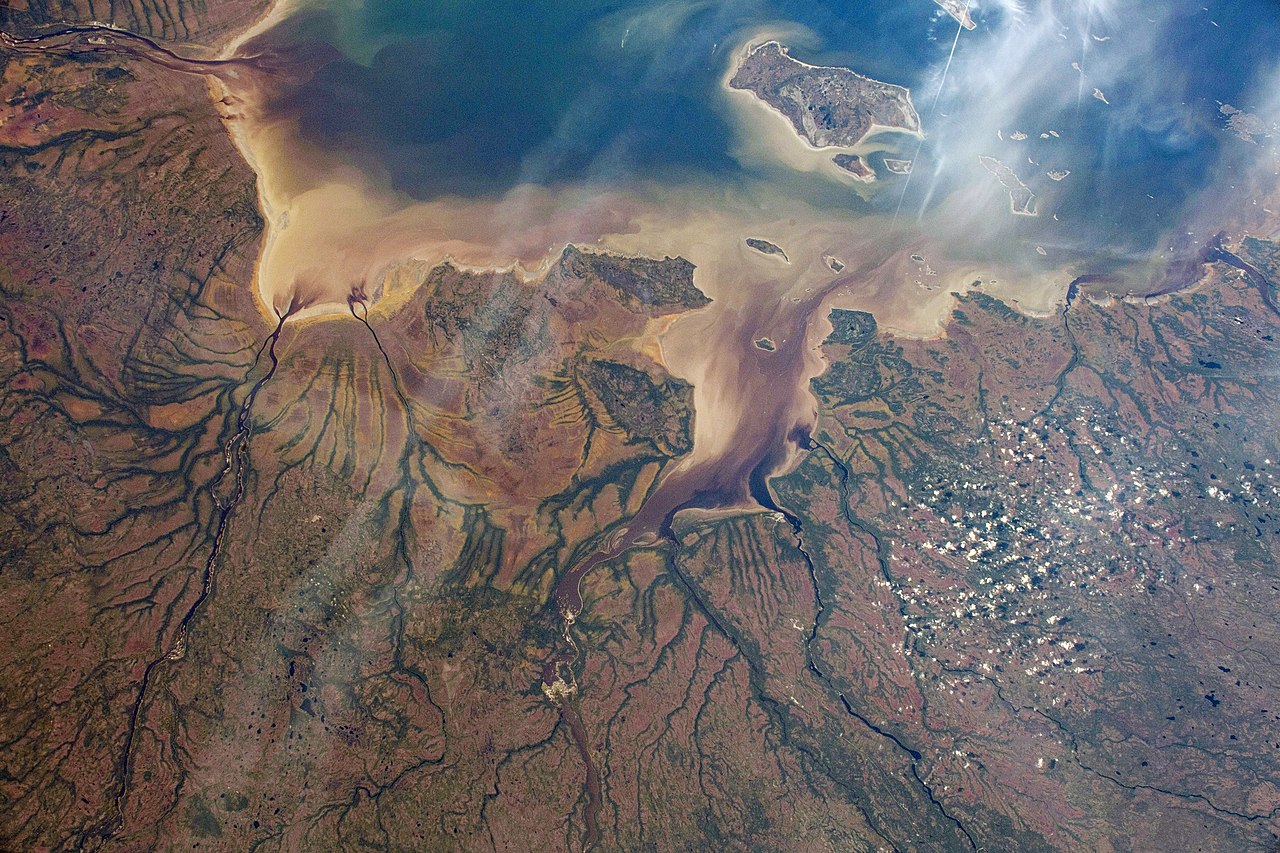
English: The Nottaway River empties into the southern tip of James Bay in the Canadian province of Quebec. The International Space Station was orbiting 252 miles above North America and 189 miles south of James Bay at the time this photograph was taken. |
| Date | Taken on 8 October 2019 |
| Source | https://www.flickr.com/photos/nasa2explore/48959542722/ |
| Author | NASA |
| Other versions |
.jpg)
This image or video was catalogued by Johnson Space Center of the United States National Aeronautics and Space Administration (NASA) under Photo ID: ISS061-E-004579. This tag does not indicate the copyright status of the attached work. A normal copyright tag is still required. See Commons:Licensing. Other languages:
|
Licensing
[edit]
| This image, originally posted to Flickr, is currently not available on Flickr under the license specified on this page. However, please see {{PD-USGov-NASA-AP}} for permission to use it under this license. |
This file is in the public domain in the United States because it was created by the Image Science & Analysis Laboratory, of the NASA Johnson Space Center. NASA copyright policy states that "NASA material is not protected by copyright unless noted". (NASA media use guidelines or Conditions of Use of Astronaut Photographs).
Photo source: ISS061-E-004579.
|
File history
Click on a date/time to view the file as it appeared at that time.
| Date/Time | Thumbnail | Dimensions | User | Comment | |
|---|---|---|---|---|---|
| current | 02:58, 31 October 2019 | | 5,568 × 3,712 (3.84 MB) | Ras67 (talk | contribs) | 180 degree rotated, levels/colors adjusted |
| 02:55, 31 October 2019 |  | 5,568 × 3,712 (2.68 MB) | Ras67 (talk | contribs) | == {{int:filedesc}} == {{Information |description={{en|1=The Nottaway River empties into the southern tip of James Bay in the Canadian province of Quebec. The International Space Station was orbiting 252 miles above North America and 189 miles south of James Bay at the time this photograph was taken.}} |date={{taken on|2019-10-08}} |source=https://www.flickr.com/photos/nasa2explore/48959542722/ |author=NASA |permission= |other versions= }} {{NASA-image|center=JSC|id=ISS061-E-004579}} == {{in... |
You cannot overwrite this file.
File usage on Commons
The following 2 pages use this file:
File usage on other wikis
The following other wikis use this file:
- Usage on fr.wikipedia.org
- Usage on it.wikipedia.org
- Usage on ja.wikipedia.org
- Usage on ru.wikipedia.org