File:ISS-30 Menindee Lakes, New South Wales, Australia.jpg

From Wikimedia Commons, the free media repository
Jump to navigation Jump to search

Original file(4,288 × 2,848 pixels, file size: 1.05 MB, MIME type: image/jpeg)

Captions

Captions

Add a one-line explanation of what this file represents

Summary[edit]

Description
Afrikaans: Die Menindee-mere in Nieu-Suid-Wallis, Australië, is die onderwerp van hierdie foto wat deur 'n ekspedisie 30-bemanningslid uit die Internasionale Ruimtestasie geneem is.
  • Die Menindee-mere bestaan ​​uit 'n stel vlak varswatermere wat deur die Darlingrivier gevoed word wanneer dit oorstroom. Die mere is in die verre weste van Nieu-Suid-Wallis, Australië, naby die dorp Menindee geleë. Die langste is Tandoumeer (18,6 km noord tot suid), sigbaar regs bo op hierdie foto. Dit lyk asof die mere 'n klein hoeveelheid water ontvang het. Die Darlingrivier self het gevloei, soos aangedui deur die donker water en verswarte modder langs sy loop (links). Die Darlingrivier vloei op kronkelende wyse suidwes (onder links tot regs bo).
  • In die plat landskappe van hierdie deel van Australië het die rivier etlike binnelandse deltas in sy verloop na die see geskep, met opvallend divergerende kanaalpatrone, gekenmerk deur jonger sedimente wat gryser voorkom as die omliggende antieke rooi gronde en rotse. Een so 'n binnelandse delta verskyn regs waar nou kanale oor die platteland kronkel. Die toppunt van 'n ander binnelandse delta verskyn regs bo. Sommige van die Menindee-mere is geïnkorporeer in 'n kunsmatig gereguleerde oorloopstelsel wat voorsiening maak vir vloedbeheer, waterberging vir huishoudelike gebruik en vee, benewens besproeiing stroomaf. Die mere is ook belangrik as vleilande wat 'n ryk verskeidenheid voëllewe onderhou. Die vloer van een, Tandoumeer, is teen oorstromings beskerm en word as waardevolle landbougrond benut, soos afgelei kan word uit die opsigtelike lappieskombers van besproeiingslande.
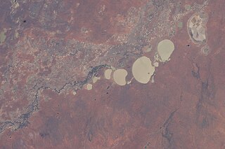
English: The Menindee Lakes, New South Wales, Australia are featured in this image photographed by an Expedition 30 crew member on the International Space Station.
  • The Menindee Lakes comprise a system of ephemeral, freshwater lakes fed by the Darling River when it floods. The lakes lie in the far west of New South Wales, Australia, near the town of Menindee. The longest is Lake Tandou (18.6 kilometers north--south dimension), visible at the upper right of this photograph. The lakes appear to have a small amount of water flooding them. The Darling River itself was flowing, as indicated by the dark water and blackened mud along its course (left). The Darling River flows southwest in tortuous fashion (bottom left to upper right).
  • In the flat landscapes of this part of Australia, the river has created several inland deltas in its course to the sea, with characteristic diverging channel patterns, marked by younger sediments, which appear grayer than the surrounding ancient red soils and rocks. One such inland delta appears at right where minor channels wind across the countryside. The apex of another inland delta appears at upper right. Some of the Menindee Lakes have been incorporated in an artificially regulated overflow system providing for flood control, water storage for domestic use and livestock, as well as downstream irrigation. The lakes are also important as wetlands supporting a rich diversity of birds. The floor of one lake, Lake Tandou, is also used as prime agricultural land, as can be seen by its patchwork of irrigated fields, and is protected from flooding.
Date
Source http://spaceflight.nasa.gov/gallery/images/station/crew-30/html/iss030e009186.html
Author NASA
Other versions
This image or video was catalogued by Johnson Space Center of the United States National Aeronautics and Space Administration (NASA) under Photo ID: ISS030-E-009186.

This tag does not indicate the copyright status of the attached work. A normal copyright tag is still required. See Commons:Licensing.
Other languages:

Licensing[edit]

Public domain
This file is in the public domain in the United States because it was created by the Image Science & Analysis Laboratory, of the NASA Johnson Space Center. NASA copyright policy states that "NASA material is not protected by copyright unless noted". (NASA media use guidelines or Conditions of Use of Astronaut Photographs). Photo source: ISS030-E-009186.

العربيَّة | Deutsch | English | español | français | italiano | kurdî | македонски | മലയാളം | português | sicilianu | +/−

File history

Click on a date/time to view the file as it appeared at that time.

Date/TimeThumbnailDimensionsUserComment
current21:19, 5 February 2012Thumbnail for version as of 21:19, 5 February 20124,288 × 2,848 (1.05 MB)Ras67 (talk | contribs){{Information |Description ={{en|1=The Menindee Lakes, New South Wales, Australia are featured in this image photographed by an Expedition 30 crew member on the International Space Station. The Menindee Lakes comprise a system of ephemeral, freshwater

Metadata