File:IFR Approach Chart, Bozeman, Montana (USA),.jpg
Jump to navigation
Jump to search

Size of this preview: 420 × 599 pixels. Other resolutions: 168 × 240 pixels | 337 × 480 pixels | 539 × 768 pixels | 718 × 1,024 pixels | 1,436 × 2,048 pixels | 4,096 × 5,840 pixels.
Original file (4,096 × 5,840 pixels, file size: 2.77 MB, MIME type: image/jpeg)
Captions
Captions
Add a one-line explanation of what this file represents
Summary[edit]
,.jpg&action=edit§ion=1)
| Description |
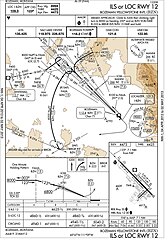
Deutsch: IFR - Anflugkarte, Flugplatz Bozeman in Montana (USA) mit Angaben zum Sinkflug- und zur Landebahn
English: IFR-Approach Chart, Airport Bozeman, Montana (USA) with details for descent and runway |
| Date | |
| Source | https://www.ifr-magazine.com/charts-plates/all-fixed-up/ |
| Author | U.S. DEPARTMENT OF TRANSPORTATION, Federal Aviation Administration |
Licensing[edit]
,.jpg&action=edit§ion=2)
This work is in the public domain in the United States because it is a work prepared by an officer or employee of the United States Government as part of that person’s official duties under the terms of Title 17, Chapter 1, Section 105 of the US Code.
Note: This only applies to original works of the Federal Government and not to the work of any individual U.S. state, territory, commonwealth, county, municipality, or any other subdivision. This template also does not apply to postage stamp designs published by the United States Postal Service since 1978. (See § 313.6(C)(1) of Compendium of U.S. Copyright Office Practices). It also does not apply to certain US coins; see The US Mint Terms of Use.
|
 | |
| This file has been identified as being free of known restrictions under copyright law, including all related and neighboring rights. | ||
File history
Click on a date/time to view the file as it appeared at that time.
| Date/Time | Thumbnail | Dimensions | User | Comment | |
|---|---|---|---|---|---|
| current | 20:42, 9 May 2024 | | 4,096 × 5,840 (2.77 MB) | Peter Christian Riemann (talk | contribs) | Uploaded a work by U.S. DEPARTMENT OF TRANSPORTATION, Federal Aviation Administration from https://www.ifr-magazine.com/charts-plates/all-fixed-up/ with UploadWizard |
You cannot overwrite this file.
File usage on Commons
The following 2 pages use this file:
File usage on other wikis
The following other wikis use this file:
- Usage on de.wikipedia.org
,.jpg&oldid=875512077)