File:IAN 0632 Chrysochoou 1881.jpg
Jump to navigation
Jump to search

Size of this preview: 737 × 600 pixels. Other resolutions: 295 × 240 pixels | 590 × 480 pixels | 944 × 768 pixels | 1,259 × 1,024 pixels | 2,517 × 2,048 pixels | 7,128 × 5,800 pixels.
Original file (7,128 × 5,800 pixels, file size: 44.34 MB, MIME type: image/jpeg)
Captions
Captions
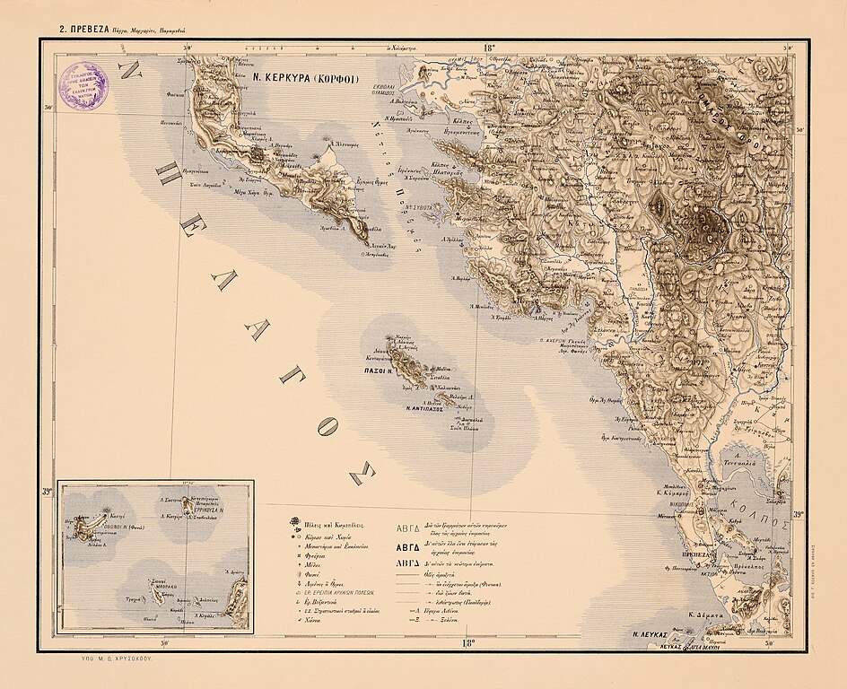
Map of western Epirus, including most of the region of Preveza and Thesprotia, the islands of Paxos, Antipaxos, and part of the islands of Corfu and Lefkas, published by the Michael Xrysochoos
Summary[edit]
| Title | ||||||||||||||||||||||||
| Description |
English: Map of western Epirus, including most of the region of Preveza and Thesprotia, the islands of Paxos, Antipaxos, and part of the islands of Corfu and Lefkas, published by the Michael Xrysochoos. Printed in Lithography, by G. Kolman, Athens, 1881. Nikos D. Karabelas map collection, Actia Nicopolis Foundation, Preveza, Greece.
Ελληνικά: Χάρτης της δυτικής Ηπείρου, που συμπεριλαμβάνει το μεγαλύτερο μέρος των νομών Πρέβεζας και Θεσπρωτίας, τις νήσους Παξούς, Αντίπαξους, και μέρος της νήσου Κέρκυρας και Λευκάδας. Εκδόθηκε από τον Μιχαήλ Θ. Χρυσοχόο, σε λιθογραφία του Γ. Κόλμαν, στην Αθήνα, το 1881. Συλλογή χαρτών Νίκου Δ. Καράμπελα, Ίδρυμα Ακτία Νικόπολις, Πρέβεζα |
|||||||||||||||||||||||
| Date | ||||||||||||||||||||||||
| Source |
Πίναξ τῆς Μεσημβρινῆς Ἠπείρου καί τῆς Θεσσαλίας, ἐκπονηθείς ὑπό Μιχαήλ Θ. Χρυσοχόου, Ζιτσαίου, τῇ συνδρομῇ τῆς Ἐπιτροπῆς τῆς Ἐθνικῆς Ἀμύνης καί Ἀδελφότητος καί τοῦ πρός διάδοσιν τῶν Ἑλλην. Γραμμάτων Συλλόγου, ἐν Ἀθήναις κατά Μάρτιον τοῦ 1881, κλῖμαξ 1:200,000. Ἀθήνα, λιθογραφεῖο Γ. Κόλμαν.
|
|||||||||||||||||||||||
| Creator |
|
|||||||||||||||||||||||
| Permission (Reusing this file) |
This file is licensed under the Creative Commons Attribution 4.0 International license.
| |||||||||||||||||||||||
| Attribution (required by the license) | ||||||||||||||||||||||||
| Geotemporal data | ||||||||||||||||||||||||
| Date depicted | ||||||||||||||||||||||||
| Map location | Western Epirus, Greece | |||||||||||||||||||||||
| Map type | map | |||||||||||||||||||||||
| Scale | 1:200.000 | |||||||||||||||||||||||
| Heading |
 |
|||||||||||||||||||||||
| Bounding box |
|
|||||||||||||||||||||||
| Georeferencing | If inappropriate please set warp_status = skip to hide. | |||||||||||||||||||||||
| Bibliographic data | ||||||||||||||||||||||||
| Part of the series |
English: Actia Nicopolis Foundation, Preveza, Greece. Nikos D. Karabelas map collection. Ελληνικά: Ίδρυμα Ακτία Νικόπολις, Πρέβεζα. Συλλογή χαρτών Νίκου Δ. Καράμπελα. |
|||||||||||||||||||||||
| Map sheet | IAN 0632 | |||||||||||||||||||||||
| Language | Greek | |||||||||||||||||||||||
| Printed by |
Λιθογραφείον Γ. Κόλμαν, εν Αθήναις |
|||||||||||||||||||||||
| Archival data | ||||||||||||||||||||||||
| Collection |
|
|||||||||||||||||||||||
| Accession number |
IAN_0632 |
|||||||||||||||||||||||
| Dimensions | height: 437 mm (17.20 in); width: 550 mm (21.65 in) | |||||||||||||||||||||||
| Medium |
English: Lithography. Ελληνικά: Λιθογραφία. |
|||||||||||||||||||||||
| Inscriptions | Κέρκυρα (Κορφοί) / εκβολαί Θυάμιδος / Θύαμις π. / Χατζή-Κασίμ / Μ. Ραγιού / ποτ. Καλαμάς / Λ. Βαλτούκα / Ν. Πρασσούδι / Αγιόνησος / Κόλπος Ηγουμενίτσας / Κυτάνη / Γουμενίτσα (Γράβα) / Κόλπος Πλαταριάς / Πλαταριά / Ιερόνησος / Α. Σαρούνα / Νοι Σύβοτα / Μούρτοι (Βόλια) / Λ. Αρίλλας / Αρίλλα / Αρπίτσα / Μαργαρίτι / Κούγκι / Σούλι / Σαμονίβα / Κιάφα / Αμβρίκον (Αβαρίκο) / Γλυκύ / Αχέρων π. / Φαναριώτικος / Πανδοσία (Πανδωσία) / Κοκυτός π / Βουβός π. / Αχερουσία / Καστρί / Κωρώνη / Τουρκοπάλουκο / Μαρφάτι (Μορφάτι) / Αγιά / Α. Βαρλάμ / Πάργα / Α. Μονόλιθος / Α. Τροφάλι / Λ. Πάργας / Λιμ. Άγ. Ιωάννης / Σπλάντσα / Φανάρι / Γλυκύς / Μαυροπόταμον / Λιμ. Φανάρι / Αμουνά (Αμμουδιά) / Βαλανιδόραχον / Τσουκνίδα / Καναλάκι / Κράβαρι / όρος Ζάλογγος / Βλάδον / Πλαιουρόφορον (Παλαιορόφορος) / Μουζάκα / Λούρος / ποτ. Λούρος / Οροπός (Ωρωπός) / Φιλιππιάς / Ρωμιά / Λευθεροχώρι (Ελευθεροχώρι) / Καντσάς / Μετόχι / Άγ. Ηλίας / Ρωγοί / Ιμάμ Τσαούς (Άγιος Σπυρίδωνας) / Ρουμπά / Πέτρα / Ράχη / Βίγλα / Σρογγυλή / Όρ. Γρίμποβον / Οροπός ποτ. / Λιμπόχοβον / Μ. Ζάλογγου / Στεφάνι / Τοπόλια (Τοπόλα) / Δούβιανη (Κρυοπηγή) / Κλαρέντζα / Ελαία; / Λούτσα / Τομαροχώρια / Όρμ. Άγ. Θωμάς / Ελιά / Κασσώπη / Σακάσα / Αγ. Ευφημία / Ρηνιάσσα / Σύνδεκλα (Συντεκλιά) / Μονόδενδρον / Καμαρίνα / Λάμαρη / Μαρταιοί (Μαρτανιοί) / Όρμ. Καστροσυκιάς / Βουχαίτιον / Καστροσυκιά / Φλάμπουρον / Καναλόπουλον / Κανάλι / Λ. Τσουκαλιά / Σαλαχώρα (Σαλαώρα) / Μιχαλίτσι / Όρ. Μιχαλίτσι / Μονολίθιον / Κ. Κόμαρος / Νικόπολις / Μύτικας / Μάζωμα / Κοθρά / Μυρτάβι (Μυρτάρι) / Λ. Βαθύς / Αγ. Ευθυμία / Πρέβεζα / Φρ. Παντοκράτορ (Παντοκράτορας) / Άγ. Γεώργιος / Άκτιον / Φρ. Πούντα / Πρόκολπος / Ανεμόμ. (Ανεμόμυλος) / Στέφανος / Α. Σκάφη / Γαδαρονήσι / Α. Παναγιά / Ανακτόριον / Άγ. Απόστολος / Όρ. Κόμινον / Κ. Δέματα / Χελοβίβαρον / Καλύβαι / Όρ. Αρνύτσα / Λιμ. Βουλγαρία (Βουλκαριά) / Όρ. Μούμια / Περατιά / Λευκάς / Αγία Μαύρα / κ.α. | |||||||||||||||||||||||

- Error in {{Map}} template: unknown parameter "1", "2", "3", "4", "5", "6", "7", "8".
File history
Click on a date/time to view the file as it appeared at that time.
| Date/Time | Thumbnail | Dimensions | User | Comment | |
|---|---|---|---|---|---|
| current | 11:52, 22 January 2019 | | 7,128 × 5,800 (44.34 MB) | Actia Nicopolis (talk | contribs) | {{Information |Description= |Source={{own}} |Date= |Author= Actia Nicopolis |Permission= |other_versions= }} |
You cannot overwrite this file.
File usage on Commons
The following page uses this file:
- File:IAN 0632.jpg (file redirect)
File usage on other wikis
The following other wikis use this file:
- Usage on el.wikipedia.org