File:IAN 0189 Dapper 1688 Santa Maura.jpg
Jump to navigation
Jump to search
Size of this preview: 741 × 599 pixels. Other resolutions: 297 × 240 pixels | 594 × 480 pixels | 950 × 768 pixels | 1,266 × 1,024 pixels | 2,532 × 2,048 pixels | 3,887 × 3,144 pixels.
Original file (3,887 × 3,144 pixels, file size: 5.45 MB, MIME type: image/jpeg)
Captions
Captions
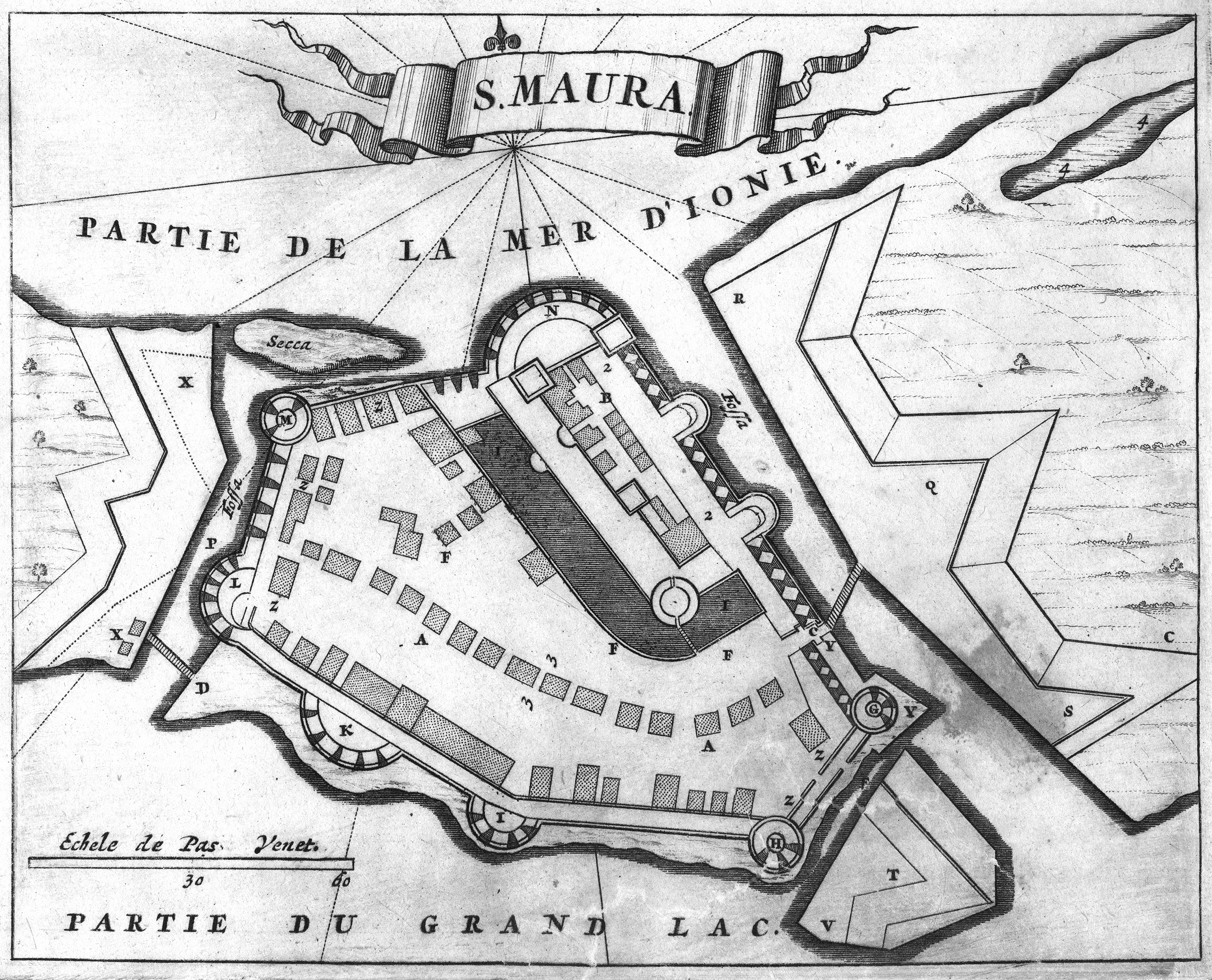
The castle of Santa Maura. Copper engraving by Olfert Dapper, 1688.
Summary[edit]
| Title | ||||||||||||||||||||||||
| Description |
English: The castle of Santa Maura. Copper engraving by Olfert Dapper, 1688. Nikos D. Karabelas map collection, Actia Nicopolis Foundation, Preveza, Greece.
Ελληνικά: Το κάστρο της Αγίας Μαύρας. Χαλκογραφία του Όλφερτ Ντάπερ του 1688. Συλλογή χαρτών Νίκου Δ. Καράμπελα, Ίδρυμα Ακτία Νικόπολις, Πρέβεζα |
|||||||||||||||||||||||
| Date | ||||||||||||||||||||||||
| Source | Olfert Dapper, Naukeurige Beschryving Van Morea, Eertijts Peloponnesus; En de Eilanden, Gelegen onder de kusten van Morea, en binnen en buiten de Golf van Venetien: waer onder de voornaemste Korfu, Cefalonia, Sant Maura, Zanten en anderen in grooten getale. Behelzende derzelver Lantschappen, steden, rivieren, poelen, bergen, gewassen, dieren, &c. Met de kaerten van Morea, Golf van Venetien, en verscheide eilanden: benessens afbeeldingen van steden en kastelen, als Patrasso, Modon, Koron, Navarino, Napoli di Romania en Malvasia, Korinthen, Misitra &c., Amsterdam, Wolfgangh, Waesbergen, Boom, Someren en Goethals, 1688. | |||||||||||||||||||||||
| Creator |
|
|||||||||||||||||||||||
| Permission (Reusing this file) |
This file is licensed under the Creative Commons Attribution 4.0 International license.
| |||||||||||||||||||||||
| Attribution (required by the license) | ||||||||||||||||||||||||
| Geotemporal data | ||||||||||||||||||||||||
| Date depicted | 1684, when the Venetians captured Santa Maura. | |||||||||||||||||||||||
| Map location | Lefkada, Greece | |||||||||||||||||||||||
| Map type | topographical chart | |||||||||||||||||||||||
| Spatial reference system | Mercator | |||||||||||||||||||||||
| Scale | Passi Veneta 60 | |||||||||||||||||||||||
| Heading |
 |
|||||||||||||||||||||||
| Bounding box |
|
|||||||||||||||||||||||
| Georeferencing | If inappropriate please set warp_status = skip to hide. | |||||||||||||||||||||||
| Bibliographic data | ||||||||||||||||||||||||
| Part of the series |
English: Actia Nicopolis Foundation, Preveza, Greece. Nikos D. Karabelas map collection. Ελληνικά: Ίδρυμα Ακτία Νικόπολις, Πρέβεζα. Συλλογή χαρτών Νίκου Δ. Καράμπελα. |
|||||||||||||||||||||||
| Map sheet | IAN 0189 | |||||||||||||||||||||||
| Language | Dutch | |||||||||||||||||||||||
| Archival data | ||||||||||||||||||||||||
| Collection |
|
|||||||||||||||||||||||
| Accession number |
IAN_0189 |
|||||||||||||||||||||||
| Dimensions | height: 134 mm (5.27 in); width: 165 mm (6.49 in) | |||||||||||||||||||||||
| Medium |
English: Copper engraving. Ελληνικά: Χαλκογραφία. |
|||||||||||||||||||||||
| Inscriptions | S. Maura, Partie de la Mer d' Ionie, Partie du Grand Lac | |||||||||||||||||||||||
| Notes | Watermark of coat of arms with two lions facing to the right and left, and vertical lines at approximately every 25 mm | |||||||||||||||||||||||


- Error in {{Map}} template: unknown parameter "1", "2", "3", "4", "5", "6", "7", "8".
File history
Click on a date/time to view the file as it appeared at that time.
| Date/Time | Thumbnail | Dimensions | User | Comment | |
|---|---|---|---|---|---|
| current | 20:29, 9 July 2020 | | 3,887 × 3,144 (5.45 MB) | Actia Nicopolis (talk | contribs) | {{Map | title = {{it|1='''S. Maura'''.}} {{en|1=Santa Maura (Lefkada).}} {{el|1=Αγία Μαύρα (Κάστρο της Λευκάδας).}} | wikidata title = Q941736 | description = {{en|1=The castle of Santa Maura. Copper engraving by Vincenzo Maria Coronelli, 1687 c. Nikos D. Karabelas map collection, Actia Nicopolis Foundation, Preveza, Greece.}} {{el|1=Το κάστρο της Αγίας Μαύρας. Χαλκογραφία του Βιντσένζο Μαρία Κορονέλλι του 1687 περίπου. Συλ... |
You cannot overwrite this file.
File usage on Commons
The following page uses this file:
- File:IAN 0189 Coronelli 1687 Santa Maura.jpg (file redirect)
File usage on other wikis
The following other wikis use this file:
- Usage on fi.wikipedia.org