File:IAN 0125 Montagu 1760 Preveza.jpg
Jump to navigation
Jump to search

Size of this preview: 705 × 600 pixels. Other resolutions: 282 × 240 pixels | 565 × 480 pixels | 903 × 768 pixels | 1,204 × 1,024 pixels | 2,408 × 2,048 pixels | 24,268 × 20,637 pixels.
Original file (24,268 × 20,637 pixels, file size: 75.27 MB, MIME type: image/jpeg)
Captions
Captions
Add a one-line explanation of what this file represents
Summary[edit]
| Warning | The original file is very high-resolution. It might not load properly or could cause your browser to freeze when opened at full size. |
|---|
| Title |
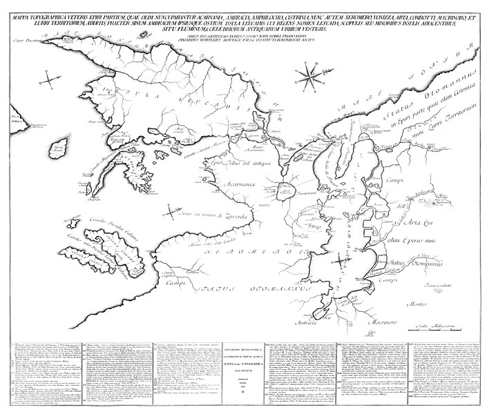
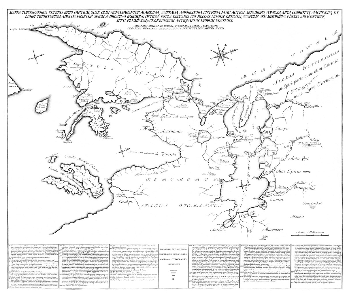
Latina: Mappa Τopographica Veteris Epiri partium, quae olim nuncupabantur Acarnania, Ambracia, Amphilochia, Cistrinia, nunc autem Xeromero, Vonizza, Arta, Combotti, Macrinoro, et Lurri Τεrritorium, additis, praeter Sinum Ambracium ipsiusque ostium, Insula Leucadis cui recens nomen Lefcada, Scopulis seu minoribus insulis adiacentibus, situ fluminum, & celebriorum antiquarum urbium vestigiis. Amico suo Amatissimo Domino Cosmo Mari Nobili Pisano D[at]. D[icat]. D[edicat]. Odoardus Wortleius Montagu F.R.S. & Instituti Bononiensis Socius. |
|||||||||||||||||||||||
| Description |
English: An extremely rare map of the Amvrakikos bay, Preveza, Xeromero, and Lefkas island, during the second half of the 18th century. Ελληνικά: Εξαιρετικά σπάνιος χάρτης του Αμβρακικού κόλπου, της Πρέβεζας, του Ξηρομέρου και της νήσου Λευκάδας, στη διάρκεια της δεύτερης Ενετικής κατοχής της Πρέβεζας περί τα μέσα του 18ου αιώνα. |
|||||||||||||||||||||||
| Date | circa 1760 | |||||||||||||||||||||||
| Source |
|
|||||||||||||||||||||||
| Creator | ||||||||||||||||||||||||
| Permission (Reusing this file) |
This file is licensed under the Creative Commons Attribution 4.0 International license.
| |||||||||||||||||||||||
| Attribution (required by the license) | ||||||||||||||||||||||||
| Geotemporal data | ||||||||||||||||||||||||
| Date depicted | c. | |||||||||||||||||||||||
| Map location | Amvrakikos Gulf, Greece | |||||||||||||||||||||||
| Map type | map | |||||||||||||||||||||||
| Scale | Scala Milliariorum 5 | |||||||||||||||||||||||
| Heading |
 |
|||||||||||||||||||||||
| Bounding box |
|
|||||||||||||||||||||||
| Georeferencing | If inappropriate please set warp_status = skip to hide. | |||||||||||||||||||||||
| Bibliographic data | ||||||||||||||||||||||||
| Part of the series |
English: Actia Nicopolis Foundation, Preveza, Greece. Nikos D. Karabelas map collection. Ελληνικά: Ίδρυμα Ακτία Νικόπολις, Πρέβεζα. Συλλογή χαρτών Νίκου Δ. Καράμπελα. |
|||||||||||||||||||||||
| Map sheet | IAN 0125 | |||||||||||||||||||||||
| Language | Latin | |||||||||||||||||||||||
| Archival data | ||||||||||||||||||||||||
| Collection |
|
|||||||||||||||||||||||
| Accession number |
IAN_0125 |
|||||||||||||||||||||||
| Dimensions | height: 1,749 mm (68.85 in); width: 2,060 mm (81.10 in) | |||||||||||||||||||||||
| Medium |
English: Copper engraving. Ελληνικά: Χαλκογραφία. |
|||||||||||||||||||||||
| Inscriptions | Mare Ionium / Insula Leucadis / Caput Ducatum / antiquum Templum / Insula Sessolae / Caput Sessolae / Portus Figher / antiqua Rudera / Portus Sivotae / Portus Rudae / antiqua Rudera / Montes dicti di Porro Vlico / Mons Scarus / Fons del Papa / Portus Glimenus / Canalis Sanctae Maurae / Insula Sparti / Insula Scorpio / Canalis Megannissi Fretum Tiliae / Insula Arcudi / Promontorium Marinacae / Ithaca / Insula Pettalae / Insula Chitro / Fochia / Vigla / Insula Meganissi / Cynotaphion / Caput Chiephali / Caput Atterinum / Epiri / Vatia Valli / Parva Insula / Macria Mitti / Sburdugna | |||||||||||||||||||||||
| Notes | The map consists of 4 seperate leaves. The upper left leaf measures 465*430 mm. The upper right leaf measures 563*429 mm. The lower left leaf measures 465*462 mm. The lower right leaf measures 567*428 mm. The whole map has been published again in: In Charta. Prints of Preveza, Preveza, 2006, Plate No. 12. According to Nikos D. Karabelas, the map is based on a very large and hand coloured manuscript map of the Ambrakikos bay and Lefkas island, drawn by Girolamo Delanges in 1757, now held at the Marciana Library in Venice, Italy. | |||||||||||||||||||||||
| Other versions | Most probably a copy of the large manuscript map of the same area by Girolamo Delanges, which was drawn in 1757. | |||||||||||||||||||||||

- Error in {{Map}} template: unknown parameter "1", "2".
File history
Click on a date/time to view the file as it appeared at that time.
| Date/Time | Thumbnail | Dimensions | User | Comment | |
|---|---|---|---|---|---|
| current | 17:42, 2 October 2018 | | 24,268 × 20,637 (75.27 MB) | Actia Nicopolis (talk | contribs) | == {{int:filedesc}} == {{Map | title = {{it|1='''Preuesa attaccata da Veneti'''.}} {{en|1=Preveza attacked by the Venetians.}} {{el|1=Η επίθεση των Ενετών κατά της Πρέβεζας.}} | wikidata title = Q284841 | description = {{en|1=Map of the Gulf of Arta, drawn by Lieutenant W. J. Cooling of H.M.S. ''Mastiff'' (1813), in 1830. Lithography by J. & C. Walker, London, 1834. Nikos D. Karabelas map collection, [[Actia Nic... |
You cannot overwrite this file.
File usage on Commons
The following page uses this file:
- File:IAN 0125.jpg (file redirect)
File usage on other wikis
The following other wikis use this file:
- Usage on de.wikipedia.org
- Usage on en.wikipedia.org
- Usage on ru.wikipedia.org