File:IAN 0106 Vincent 1701 Preveza.jpg
Jump to navigation
Jump to search
Size of this preview: 800 × 591 pixels. Other resolutions: 320 × 237 pixels | 640 × 473 pixels | 1,024 × 757 pixels | 1,280 × 946 pixels | 2,560 × 1,892 pixels | 6,240 × 4,612 pixels.
Original file (6,240 × 4,612 pixels, file size: 28.55 MB, MIME type: image/jpeg)
Captions
Captions
Add a one-line explanation of what this file represents
Summary[edit]
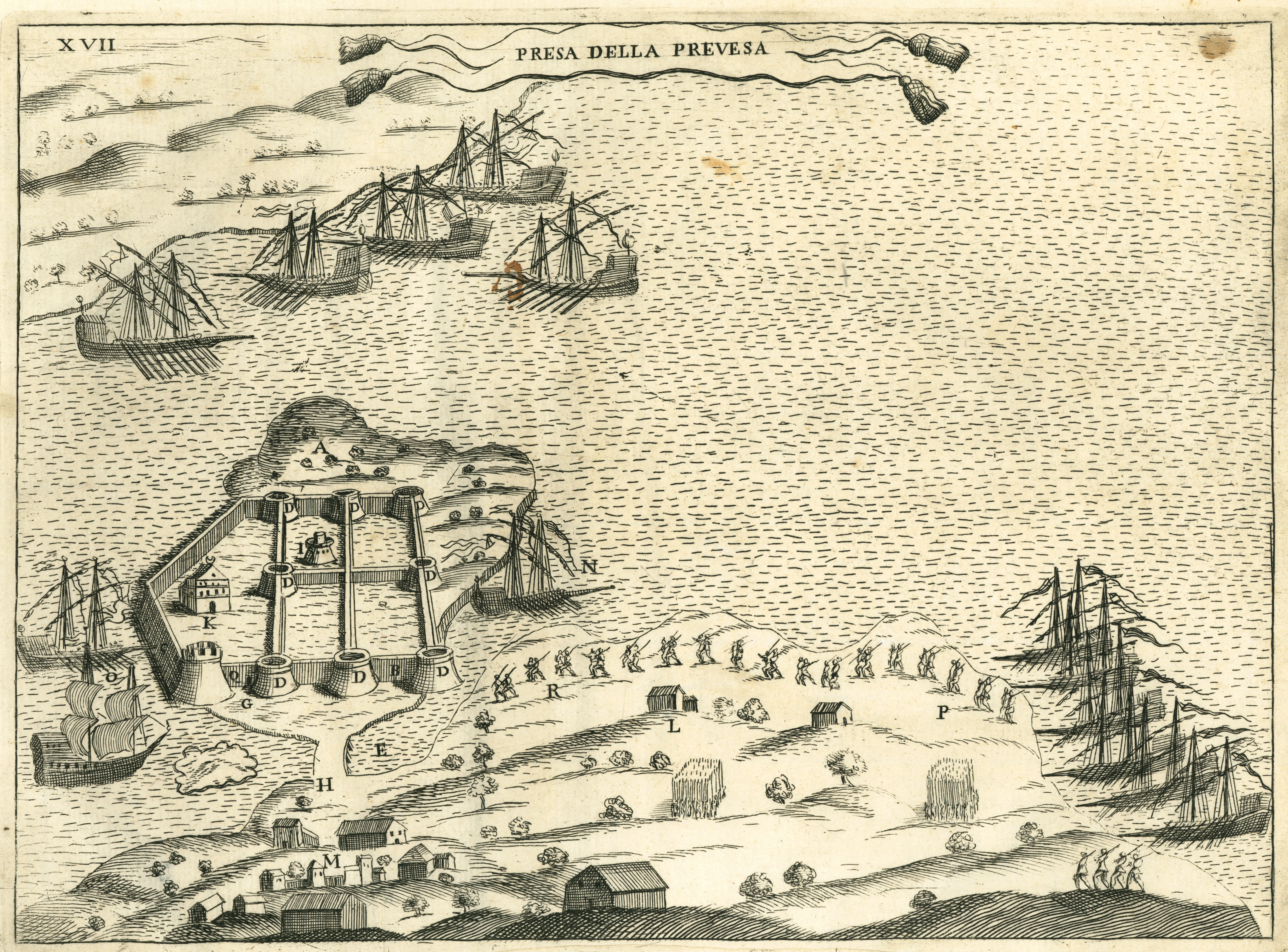
| Title |
Italiano: Presa della Prevesa. English: The capture of Preveza. Ελληνικά: Η κατάληψη της Πρέβεζας. |
|||||||||||||||||||||||
| Description |
English: The castle of Bouka in Preveza, captured by the knights of St. Stephen, in 1605. Copper engraving by Hubert Vincent, 1701. Nikos D. Karabelas map collection, Actia Nicopolis Foundation, Preveza, Greece.
Ελληνικά: Το κάστρο της Μπούκας στην Πρέβεζα, κατά την κατάληψή του από τους ιππότες του Αγίου Στεφάνου της Πίζας, το 1605. Χαλκογραφία του Ουμπέρτ Βίνσεντ του 1701. Συλλογή χαρτών Νίκου Δ. Καράμπελα, Ίδρυμα Ακτία Νικόπολις, Πρέβεζα |
|||||||||||||||||||||||
| Date | ||||||||||||||||||||||||
| Source | Fulvio Fontana, I pregi della Toscana nell' imprese piu segnalate de' cavalieri di Santo Stefano, Firenze, 1701, p. 121. | |||||||||||||||||||||||
| Creator | ||||||||||||||||||||||||
| Permission (Reusing this file) |
This file is licensed under the Creative Commons Attribution 4.0 International license.
| |||||||||||||||||||||||
| Attribution (required by the license) | ||||||||||||||||||||||||
| Geotemporal data | ||||||||||||||||||||||||
| Date depicted | 1605, when the Knights of St. Stephen captured Preveza. | |||||||||||||||||||||||
| Map location | Preveza, Greece | |||||||||||||||||||||||
| Map type | map | |||||||||||||||||||||||
| Scale | No scale | |||||||||||||||||||||||
| Heading |
 |
|||||||||||||||||||||||
| Bounding box |
|
|||||||||||||||||||||||
| Georeferencing | If inappropriate please set warp_status = skip to hide. | |||||||||||||||||||||||
| Bibliographic data | ||||||||||||||||||||||||
| Part of the series |
English: Actia Nicopolis Foundation, Preveza, Greece. Nikos D. Karabelas map collection. Ελληνικά: Ίδρυμα Ακτία Νικόπολις, Πρέβεζα. Συλλογή χαρτών Νίκου Δ. Καράμπελα. |
|||||||||||||||||||||||
| Map sheet | IAN 0106 | |||||||||||||||||||||||
| Language | Italian | |||||||||||||||||||||||
| Publisher |
Fulvio Fontana |
|||||||||||||||||||||||
| Printed by |
Pier Mattia Miccioni, e Michele Nestenus |
|||||||||||||||||||||||
| Archival data | ||||||||||||||||||||||||
| Collection |
|
|||||||||||||||||||||||
| Accession number |
IAN_0106 |
|||||||||||||||||||||||
| Dimensions | height: 194 mm (7.63 in); width: 265 mm (10.43 in) | |||||||||||||||||||||||
| Medium |
English: Copper engraving. Ελληνικά: Χαλκογραφία. |
|||||||||||||||||||||||
| Inscriptions | XVII PRESA DELLA PREVESA | |||||||||||||||||||||||
| Notes | Watermark. Horizontal lines at approximately every 25-35 mm | |||||||||||||||||||||||

- Error in {{Map}} template: unknown parameter "1", "2", "3", "4", "5", "6", "7", "8".
File history
Click on a date/time to view the file as it appeared at that time.
| Date/Time | Thumbnail | Dimensions | User | Comment | |
|---|---|---|---|---|---|
| current | 16:55, 8 March 2016 | | 6,240 × 4,612 (28.55 MB) | Actia Nicopolis (talk | contribs) | {{Map | title = {{it|1='''Presa della Prevesa'''.}} {{en|1=The capture of Preveza.}} {{el|1=Η κατάληψη της Πρέβεζας.}} | wikidata title = Q213898 | description = {{en|1=The castle of Bouka in Preveza, cap... |
You cannot overwrite this file.
File usage on Commons
The following page uses this file:
- File:IAN 0106.jpg (file redirect)
File usage on other wikis
The following other wikis use this file:
- Usage on bg.wikipedia.org
- Usage on ru.wikipedia.org
- Usage on uk.wikipedia.org