File:Hurricane Irene Tide Data 8516945 (Kings Point, NY).png
Jump to navigation
Jump to search
No higher resolution available.
Hurricane_Irene_Tide_Data_8516945_(Kings_Point,_NY).png (768 × 384 pixels, file size: 8 KB, MIME type: image/png)
Captions
Captions
Add a one-line explanation of what this file represents
Summary[edit]
.png&action=edit§ion=1)
| Description |
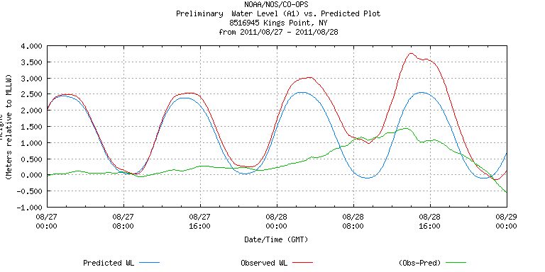
English: NOAA Tide Data for Kings Point, NY during Hurricane Irene (2011)
Deutsch: NOAA-Tidendaten für Kings Point, NY während Hurrikan Irene (2011) |
| Date | |
| Source | http://tidesandcurrents.noaa.gov/data_menu.shtml?datum=6&unit=1&bdate=20110827&edate=20110828&wl_sensor_hist=&unit=1&shift=&stn=8516945%20Kings%20Point,%20NY&type=Tide%20Data&relative=&format=View+Plot |
| Author | NOAA |
Licensing[edit]
.png&action=edit§ion=2)
This image is in the public domain because it contains materials that originally came from the U.S. National Oceanic and Atmospheric Administration, taken or made as part of an employee's official duties.
|
File history
Click on a date/time to view the file as it appeared at that time.
| Date/Time | Thumbnail | Dimensions | User | Comment | |
|---|---|---|---|---|---|
| current | 19:23, 30 August 2011 | | 768 × 384 (8 KB) | Matthiasb (talk | contribs) | same file as before but with metric data |
| 19:13, 30 August 2011 |  | 768 × 384 (8 KB) | Matthiasb (talk | contribs) | {{Information |Description ={{en|1=NOAA Tide Data for Kings Point, NY during Hurricane Irene (2011)}} {{de|1=NOAA-Tidendaten für Kings Point, NY während Hurrikan Irene (2011)}} |Source =http://tidesandcurrents.noaa.gov/data_menu.shtml?datum=6 |
You cannot overwrite this file.
File usage on Commons
There are no pages that use this file.
.png&oldid=568221682)