File:Hurricane Gaston 2004.jpg
Jump to navigation
Jump to search

Size of this preview: 733 × 600 pixels. Other resolutions: 293 × 240 pixels | 587 × 480 pixels | 939 × 768 pixels | 1,252 × 1,024 pixels | 2,503 × 2,048 pixels | 4,400 × 3,600 pixels.
Original file (4,400 × 3,600 pixels, file size: 3.2 MB, MIME type: image/jpeg)
Captions
Captions
Add a one-line explanation of what this file represents
Summary[edit]
| Description |
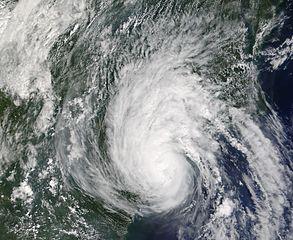
The MODIS instrument aboard NASA's Terra satellite captured this true-color image of Tropical Storm Gaston just after it came ashore near McClellanville, South Carolina. At the time this image was taken, Gaston had maximum sustained winds near 60 mph and was dumping copious amounts rain in North and South Carolina. The MODIS Rapid Response System provides this image at additional resolutions and formats. |
|||
| Date | ||||
| Source | http://earthobservatory.nasa.gov/NaturalHazards/natural_hazards_v2.php3?img_id=12377 | |||
| Author | NASA image courtesy Jeff Schmaltz, MODIS Land Rapid Response Team at NASA GSFC. | |||
| Permission (Reusing this file) |
|
File history
Click on a date/time to view the file as it appeared at that time.
| Date/Time | Thumbnail | Dimensions | User | Comment | |
|---|---|---|---|---|---|
| current | 21:13, 17 August 2006 | | 4,400 × 3,600 (3.2 MB) | Good kitty (talk | contribs) | == Summary == {{Information |Description=The MODIS instrument aboard NASA's Terra satellite captured this true-color image of Tropical Storm Gaston just after it came ashore near McClellanville, South Carolina. At the time this image was taken, Gaston had |
You cannot overwrite this file.
File usage on Commons
The following 2 pages use this file:
File usage on other wikis
The following other wikis use this file:
- Usage on de.wikipedia.org
- Usage on en.wikipedia.org
- Usage on es.wikipedia.org
- Usage on fr.wikipedia.org
- Usage on pt.wikipedia.org
- Usage on simple.wikipedia.org
- Usage on www.wikidata.org