File:Hurricane Chris (MODIS 2018-07-12).jpg

Original file (8,071 × 8,227 pixels, file size: 9.13 MB, MIME type: image/jpeg)
Captions
Captions
Summary[edit]
.jpg&action=edit§ion=1)
| Description |
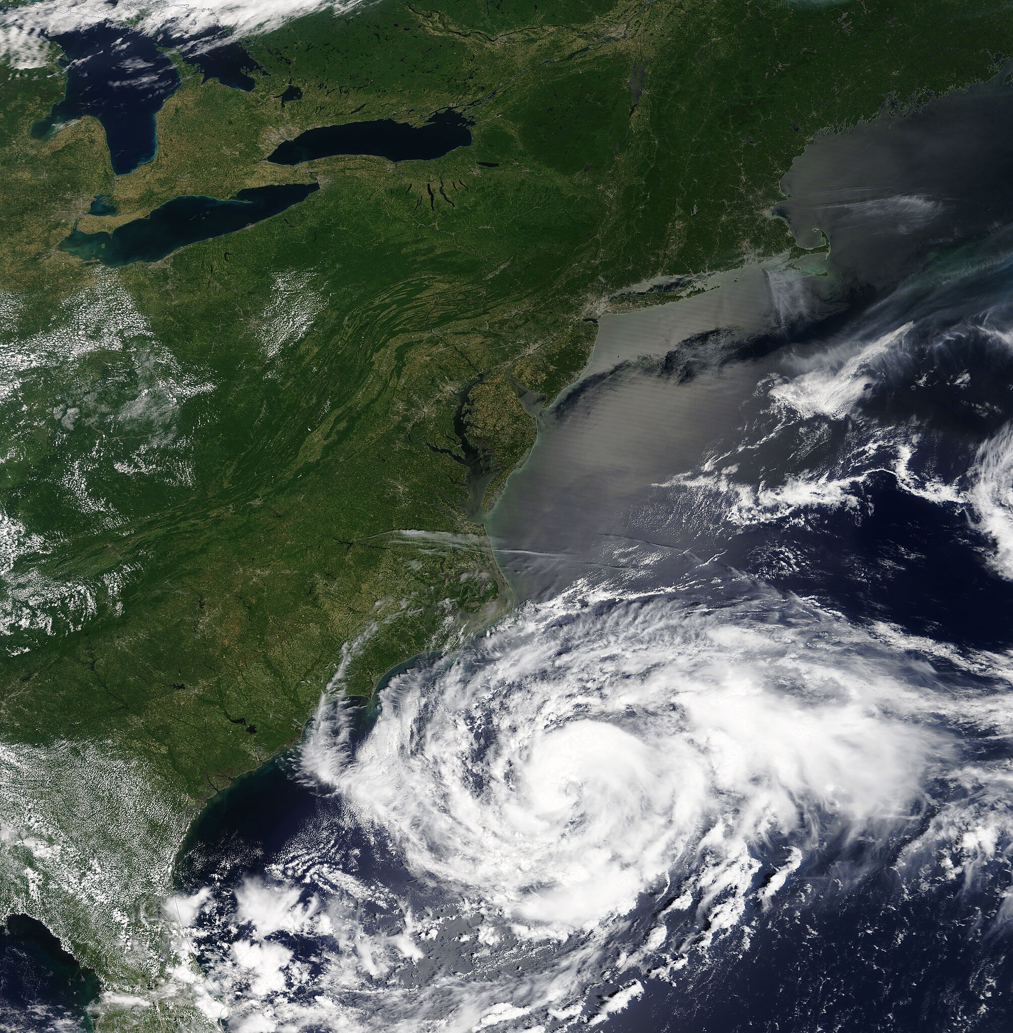
English: As NASA’s Aqua satellite passed over the eastern United States on July 9, 2018, the Moderate Resolution Imaging Spectroradiometer (MODIS) on board acquired a true-color image of Tropical Storm Chris as it was strengthening over the open water of the Atlantic Ocean.
Chris became a hurricane at 5:00 p.m. EDT (2100 UTC) on July 10 with maximum sustained winds of 85 mph (140 km/h) according to the National Hurricane Center (NHC). By 11:00 p.m. EDT on that same date (0300 UTC July 11), Hurricane Chris’ winds had increased to 105 mph (165 km/h), making it a Category Two storm on the Saffir-Simpson Hurricane Wind Scale. Chris formed from a depression well off the Cape Hatteras, North Carolina coast on July 6. It meandered in the same general area for three days before strengthening and speeding off to the north-northeast on July 10. The storm has brought heavy surf and rip-tides to beaches from North Carolina to Maryland as well as cloudy skies and rain as the outer bands reached the coast. Most of the wind and heaviest rains have remained over the open water of the Atlantic Ocean. At 5:00 pm EDT (2100 UTC) on July 11, the NHC advisory noted that Hurricane Chris had maintained strength and increased forward speed, and was “skedaddling northeastward over the open Atlantic”. It was located at 37.8 North and 65.7 West, or about 570 miles (920 km) east northeast of Cape Hatteras and about 890 miles (1,430 km) southwest of Cape Race, Newfoundland. Hurricane Chris was carrying maximum sustained winds of 90 mph (150 km/h). Chris is predicted to maintain strength for a short time and then begin to weaken as it accelerates northeastward for the next 72 hours. It is expected to pass over or near Newfoundland on July 13 or 14 as a strong extra-tropical cyclone. |
||
| Date | Taken on 9 July 2018 | ||
| Source |
|
||
| Author | Jeff Schmaltz, MODIS Land Rapid Response Team, NASA GSFC |
| This media is a product of the Aqua mission Credit and attribution belongs to the mission team, if not already specified in the "author" row |
Licensing[edit]
.jpg&action=edit§ion=2)
| This file is in the public domain in the United States because it was solely created by NASA. NASA copyright policy states that "NASA material is not protected by copyright unless noted". (See Template:PD-USGov, NASA copyright policy page or JPL Image Use Policy.) | ||
 |
Warnings:
|
File history
Click on a date/time to view the file as it appeared at that time.
| Date/Time | Thumbnail | Dimensions | User | Comment | |
|---|---|---|---|---|---|
| current | 01:39, 17 February 2024 | | 8,071 × 8,227 (9.13 MB) | OptimusPrimeBot (talk | contribs) | #Spacemedia - Upload of http://modis.gsfc.nasa.gov/gallery/images/image07122018_250m.jpg via Commons:Spacemedia |
You cannot overwrite this file.
File usage on Commons
There are no pages that use this file.
.jpg&oldid=852750653)