File:Hungary geo divided.jpg
Jump to navigation
Jump to search
Size of this preview: 800 × 499 pixels. Other resolutions: 320 × 200 pixels | 640 × 400 pixels | 977 × 610 pixels.
Original file (977 × 610 pixels, file size: 98 KB, MIME type: image/jpeg)
Captions
Captions
Add a one-line explanation of what this file represents

|
This map has been uploaded by Electionworld from en.wikipedia.org to enable the |
Summary[edit]
| Description |
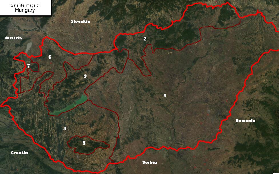
Satellite image of Hungary, with geographical subdivisions. Related: Geography of Hungary. English: Satellite image showing the 7 main geographical regions of Hungary (in parenthesis: mayor region): 1., Great Alföld (Great Alföld) 2., Northern Medium Mountains (Northern Hills) 3., Transdanubian Medium Mountains (Transdanubia) 4., Transdanubian Hills (Transdanubia) 5., Mecsek Mountains (Transdanubia) 6., Little Alföld (Transdanubia) 7., Alpokalja (Transdanubia) |
| Source |
|
| Author |
Licensing[edit]
I, the copyright holder of this work, hereby publish it under the following licenses:

|
Permission is granted to copy, distribute and/or modify this document under the terms of the GNU Free Documentation License, Version 1.2 or any later version published by the Free Software Foundation; with no Invariant Sections, no Front-Cover Texts, and no Back-Cover Texts. A copy of the license is included in the section entitled GNU Free Documentation License. |
| This file is licensed under the Creative Commons Attribution-Share Alike 3.0 Unported license. | ||
| ||
| This licensing tag was added to this file as part of the GFDL licensing update. |
This file is licensed under the Creative Commons Attribution-Share Alike 2.5 Generic, 2.0 Generic and 1.0 Generic license.
- You are free:
- to share – to copy, distribute and transmit the work
- to remix – to adapt the work
- Under the following conditions:
- attribution – You must give appropriate credit, provide a link to the license, and indicate if changes were made. You may do so in any reasonable manner, but not in any way that suggests the licensor endorses you or your use.
- share alike – If you remix, transform, or build upon the material, you must distribute your contributions under the same or compatible license as the original.
You may select the license of your choice.
Licensing of the original image:
| This file is in the public domain in the United States because it was solely created by NASA. NASA copyright policy states that "NASA material is not protected by copyright unless noted". (See Template:PD-USGov, NASA copyright policy page or JPL Image Use Policy.) | ||
 |
Warnings:
|
File history
Click on a date/time to view the file as it appeared at that time.
| Date/Time | Thumbnail | Dimensions | User | Comment | |
|---|---|---|---|---|---|
| current | 23:53, 23 December 2006 | | 977 × 610 (98 KB) | Electionworld (talk | contribs) | {{ew|en|Cserlajos}} == Summary == Satellite image showing the 7 main geographical regions of Hungary ''(in parenthesis: mayor region)'': <br>1., Great Alföld ''(Great Alföld)''<br>2., Northern Medium Mountains ''(Northern Hi |
You cannot overwrite this file.
File usage on Commons
The following page uses this file:
File usage on other wikis
The following other wikis use this file:
- Usage on be-tarask.wikipedia.org
- Usage on hu.wikipedia.org
- Usage on it.wikipedia.org
- Usage on nn.wikipedia.org
- Usage on no.wikipedia.org
- Usage on pl.wikipedia.org
- Usage on tl.wikipedia.org
- Usage on uk.wikipedia.org
- Usage on zh.wikipedia.org