File:Hours of daylight vs latitude vs day of year with tropical and polar circles.svg
Jump to navigation
Jump to search

Size of this PNG preview of this SVG file: 512 × 288 pixels. Other resolutions: 320 × 180 pixels | 640 × 360 pixels | 1,024 × 576 pixels | 1,280 × 720 pixels | 2,560 × 1,440 pixels.
Original file (SVG file, nominally 512 × 288 pixels, file size: 193 KB)
Captions
Captions
Add a one-line explanation of what this file represents
Summary[edit]
| Description |
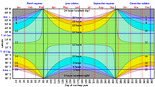
English: Modification of en:File:Hours of daylight vs latitude vs day of year cmglee.svg with the tropical and polar circles instead of the 40° latitude highlighted. |
| Date | |
| Source | Modified File:Hours of daylight vs latitude vs day of year cmglee.svg by adding the tropical and polar circles instead of the 40° latitude highlighted. |
| Author | SebastianHelm |
Licensing[edit]
I, the copyright holder of this work, hereby publish it under the following licenses:

|
Permission is granted to copy, distribute and/or modify this document under the terms of the GNU Free Documentation License, Version 1.2 or any later version published by the Free Software Foundation; with no Invariant Sections, no Front-Cover Texts, and no Back-Cover Texts. A copy of the license is included in the section entitled GNU Free Documentation License. |
This file is licensed under the Creative Commons Attribution-Share Alike 4.0 International license.
- You are free:
- to share – to copy, distribute and transmit the work
- to remix – to adapt the work
- Under the following conditions:
- attribution – You must give appropriate credit, provide a link to the license, and indicate if changes were made. You may do so in any reasonable manner, but not in any way that suggests the licensor endorses you or your use.
- share alike – If you remix, transform, or build upon the material, you must distribute your contributions under the same or compatible license as the original.
You may select the license of your choice.
File history
Click on a date/time to view the file as it appeared at that time.
| Date/Time | Thumbnail | Dimensions | User | Comment | |
|---|---|---|---|---|---|
| current | 20:42, 10 March 2020 | | 512 × 288 (193 KB) | SebastianHelm (talk | contribs) | Swapped “Anta. c.” and “Arct. c.” |
| 12:04, 16 January 2020 |  | 512 × 288 (193 KB) | SebastianHelm (talk | contribs) | swapped “Can.” and “Cap.” | |
| 21:58, 5 December 2019 |  | 512 × 288 (182 KB) | SebastianHelm (talk | contribs) | {{subst:Upload marker added by en.wp UW}} {{Information |Description = {{en|Modification of en:File:Hours of daylight vs latitude vs day of year cmglee.svg with the tropical and polar circles instead of the 40° latitude highlighted. }} |Source = Modified File:Hours of daylight vs latitude vs day of year cmglee.svg by adding the tropical and polar circles instead of the 40° latitude highlighted. |Date = 2019-12-05 |Author = SebastianHelm }} |
You cannot overwrite this file.
File usage on Commons
There are no pages that use this file.
File usage on other wikis
The following other wikis use this file:
- Usage on en.wikipedia.org
- Usage on sv.wikipedia.org