File:Hotel Alcazar (Lightner Museum and City Hall), King Street, St. Augustine, FL - 50785042957.jpg
Jump to navigation
Jump to search

Size of this preview: 449 × 599 pixels. Other resolutions: 180 × 240 pixels | 360 × 480 pixels | 576 × 768 pixels | 768 × 1,024 pixels | 1,536 × 2,048 pixels | 2,833 × 3,778 pixels.
Original file (2,833 × 3,778 pixels, file size: 2.94 MB, MIME type: image/jpeg)
Captions
Captions
Add a one-line explanation of what this file represents
Summary[edit]
,_King_Street,_St._Augustine,_FL_-_50785042957.jpg&action=edit§ion=1)
| Description |
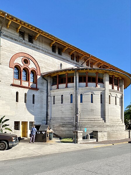
English: Built in 1887 and designed by the New York-based architecture firm of Carrère and Hastings, this Spanish Renaissance-style building was built by Henry Flagler in an effort to draw wealthy tourists to the warm winter climate of Florida. When opened, the hotel featured a large amenity wing in the rear, which housed the world’s largest indoor swimming pool, a gymnasium, locker rooms, a lounge, a bowling alley, and a spa, which featured turkish baths and a massage parlor. In addition, the building featured a spacious interior courtyard encircled by shops, and a three-story ballroom. The hotel served to extend the capacity of the larger and more popular Ponce de Leon Hotel across the street, which had been completed by Flagler prior to the Alcazar. The hotel was enlarged by the construction of a skybridge over Cordova Street and subsequent annexation of the adjacent Cordova (Casa Monica) Hotel in 1902, which increased the number of guest rooms and guest amenities available at the hotel. In 1932, following the onset of the Great Depression and subsequent reduction in tourist visits, the Hotel Alcazar closed. The hotel was utilized by the federal government during World War II, with the skybridge over Cordova Street being demolished in 1945. In 1947, the hotel was purchased by Otto C. Lightner, a publisher from Chicago, and was converted into a hobbies museum, which was turned over to the city of St. Augustine in 1948. The northern portion of the building, which encircles the interior courtyard and was formerly home to guest rooms, shops, and the main lobby, is now utilized as St. Augustine City Hall. The building was listed on the National Register of Historic Places in 1971. |
| Date | |
| Source | https://www.flickr.com/photos/59081381@N03/50785042957/ |
| Author | w_lemay |
| Camera location | | View this and other nearby images on: OpenStreetMap |
|---|
,_King_Street,_St._Augustine,_FL_-_50785042957.jpg¶ms=029.890650_N_-081.314142_E_globe:Earth_type:camera_heading:110.59&language=en)
Licensing[edit]
,_King_Street,_St._Augustine,_FL_-_50785042957.jpg&action=edit§ion=2)
This file is licensed under the Creative Commons Attribution-Share Alike 2.0 Generic license.
- You are free:
- to share – to copy, distribute and transmit the work
- to remix – to adapt the work
- Under the following conditions:
- attribution – You must give appropriate credit, provide a link to the license, and indicate if changes were made. You may do so in any reasonable manner, but not in any way that suggests the licensor endorses you or your use.
- share alike – If you remix, transform, or build upon the material, you must distribute your contributions under the same or compatible license as the original.
| This image was originally posted to Flickr by w_lemay at https://flickr.com/photos/59081381@N03/50785042957. It was reviewed on 17 March 2023 by FlickreviewR 2 and was confirmed to be licensed under the terms of the cc-by-sa-2.0. |
File history
Click on a date/time to view the file as it appeared at that time.
| Date/Time | Thumbnail | Dimensions | User | Comment | |
|---|---|---|---|---|---|
| current | 02:15, 17 March 2023 | | 2,833 × 3,778 (2.94 MB) | Ser Amantio di Nicolao (talk | contribs) | Uploaded a work by w_lemay from https://www.flickr.com/photos/59081381@N03/50785042957/ with UploadWizard |
You cannot overwrite this file.
File usage on Commons
The following page uses this file:
,_King_Street,_St._Augustine,_FL_-_50785042957.jpg&oldid=797527705)