File:Horn topo map RU.svg
Jump to navigation
Jump to search

Size of this PNG preview of this SVG file: 625 × 600 pixels. Other resolutions: 250 × 240 pixels | 500 × 480 pixels | 800 × 768 pixels | 1,067 × 1,024 pixels | 2,133 × 2,048 pixels | 1,000 × 960 pixels.
Original file (SVG file, nominally 1,000 × 960 pixels, file size: 140 KB)
Captions
Captions
Add a one-line explanation of what this file represents
| Description |
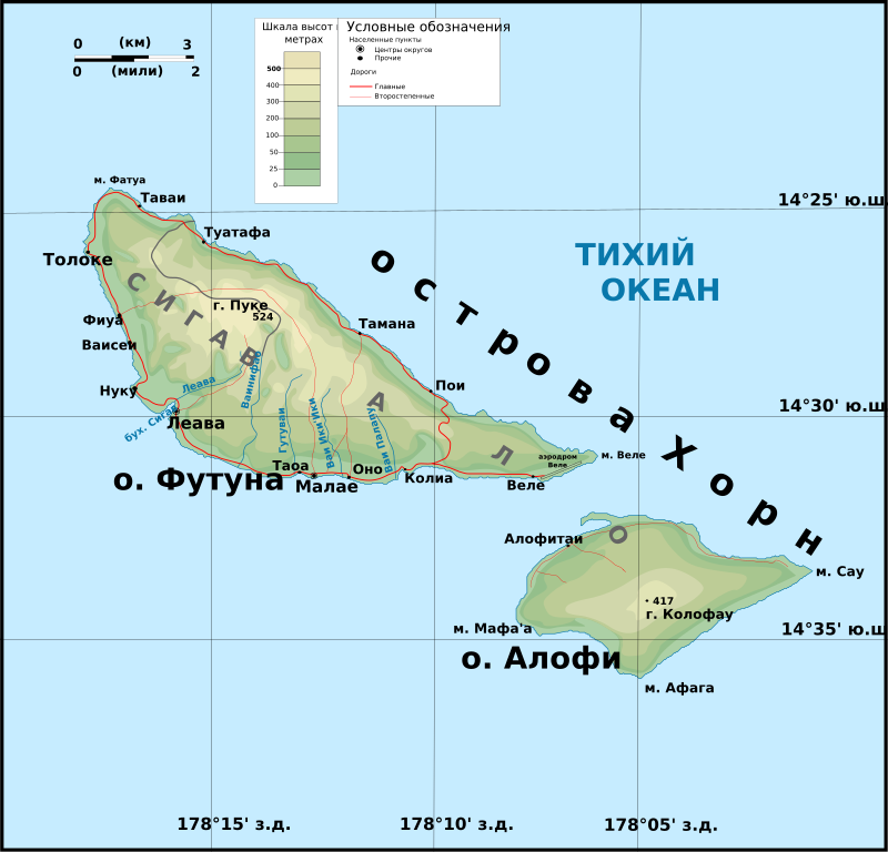
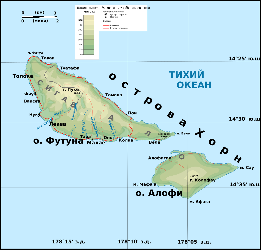
Русский: Топографическая карта островов Уоллис |
| Date | 21 October 2009 (original upload date) |
| Source |
Собственная работа. Рельеф местности от NASA Shuttle Radar Topography Mission (SRTM3 v.2.1) (public domain)(файл [1]); береговая линия и реки от [2] (файл [3]). Данные обработаны с 3DEM GRASS, векторизованны с помощью Inkscape. Затенненный рельеф создан с помощью GIMP. Дороги, географические названия с [4] Другое:
|
| Author | Boodjoom |
Licensing[edit]
Boodjoom85 at Russian Wikipedia, the copyright holder of this work, hereby publishes it under the following license:
This file is licensed under the Creative Commons Attribution-Share Alike 3.0 Unported, 2.5 Generic, 2.0 Generic and 1.0 Generic license.
Attribution: Boodjoom85 at Russian Wikipedia
- You are free:
- to share – to copy, distribute and transmit the work
- to remix – to adapt the work
- Under the following conditions:
- attribution – You must give appropriate credit, provide a link to the license, and indicate if changes were made. You may do so in any reasonable manner, but not in any way that suggests the licensor endorses you or your use.
- share alike – If you remix, transform, or build upon the material, you must distribute your contributions under the same or compatible license as the original.
Original upload log[edit]
The original description page was here. All following user names refer to ru.wikipedia.
- 2009-10-21 17:12 Переход Артур 1000×960× (142921 bytes) == Краткое описание == {{Изображение | Описание = Топографическая карта островов [[Уоллис (острова)|Уоллис]] | Источник = Собственная работа. Рельеф местности от [http://dds.cr.usgs.gov/srtm/version2_1/SRTM3/ NASA Shuttle Radar Topography Mission] (SRTM3 v.2.1) (public domain)(файл [http://dds.cr.usgs.gov/srtm/version2_1/SRTM3/Australia/S15W179.hgt.zip]); береговая линия и реки от [http://dds.cr.usgs.gov/srtm/version2_1/SWBD/] (файл [http://dds.cr.usgs.gov/srtm/version2_1/SWBD/SWBDwest/w179s15a.zip]). Данные обработаны с [http://semhur.free.fr/wiki/3dem/3dem_setup.exe 3DEM] [http://grass.itc.it/ GRASS], векторизованны с помощью [http://www.inkscape.org/?lang=ru Inkscape]. Затенненный рельеф создан с помощью [http://www.gimp.org/ GIMP]. Дороги, географические названия с [http://www.geoportail.fr/visu2D.do?ter=futuna] '''Другое''': * UTM проекция карты * Геодезическая система WGS84 * Рельеф с тенями. |Время создания = 17 октября 2009 | Автор = Boodjoom }} == Лицензирование == {{self|CC-BY-SA-3.0,2.5,2.0,1.0}}
- 2009-10-21 03:46 Boodjoom85 262×252× (141657 bytes) {{Изображение | Описание = Топографическая карта островов [[Уоллис (острова)|Уоллис]] | Источник = Собственная работа. Рельеф местности �
File history
Click on a date/time to view the file as it appeared at that time.
| Date/Time | Thumbnail | Dimensions | User | Comment | |
|---|---|---|---|---|---|
| current | 17:14, 21 October 2009 | | 1,000 × 960 (140 KB) | File Upload Bot (Magnus Manske) (talk | contribs) | {{BotMoveToCommons|ru.wikipedia|year={{subst:CURRENTYEAR}}|month={{subst:CURRENTMONTHNAME}}|day={{subst:CURRENTDAY}}}} {{Information |Description={{ru|Топографическая карта островов [[:ru:Уоллис (острова)|Уолл |
You cannot overwrite this file.
File usage on Commons
The following page uses this file: