File:Horn of Africa (MODIS 2020-11-19).jpg

Original file (2,858 × 2,487 pixels, file size: 818 KB, MIME type: image/jpeg)
Captions
Captions
Summary[edit]
.jpg&action=edit§ion=1)
| Description |
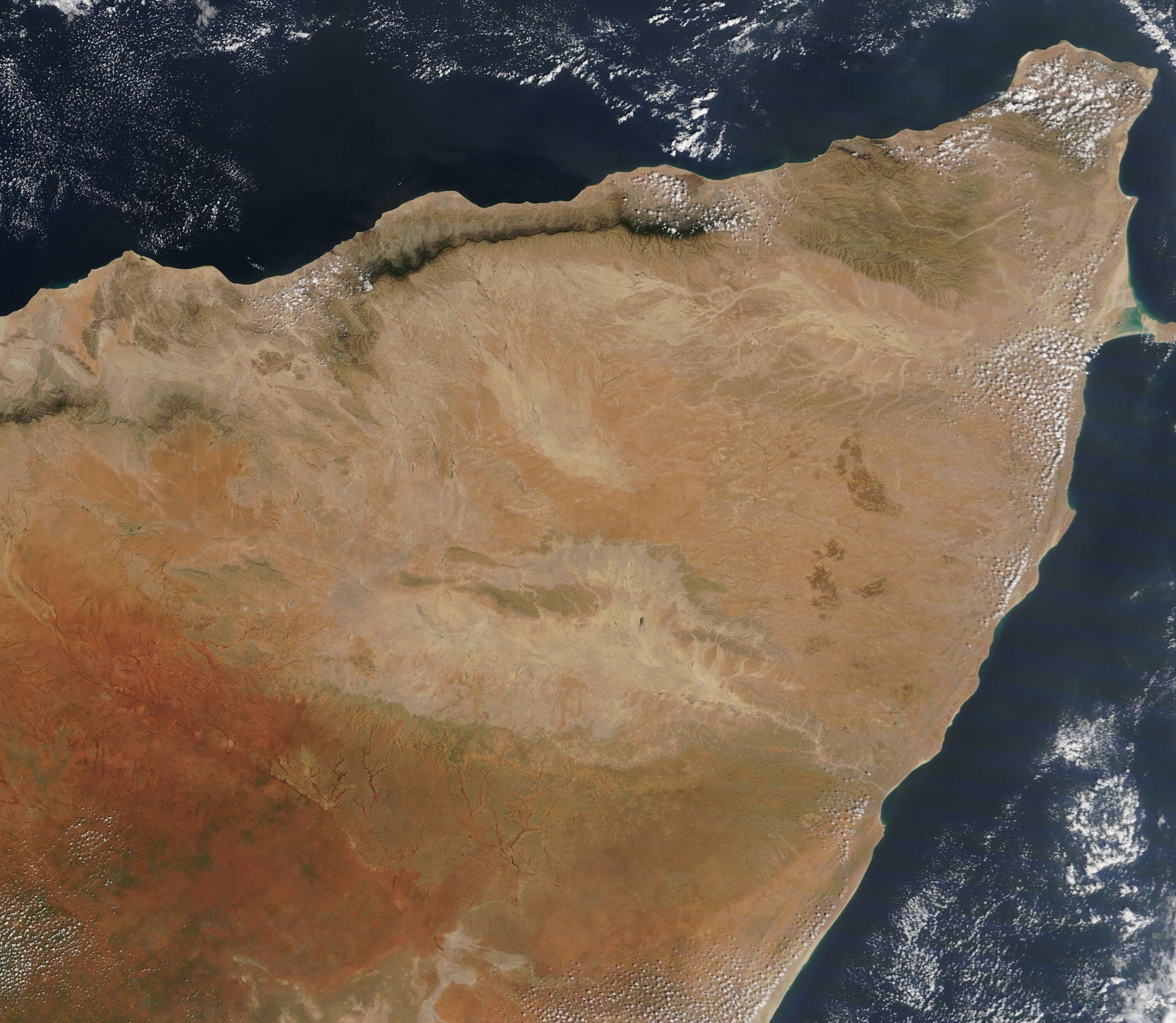
English: The tan-toned land of the Horn of Africa juts northeastward from the continent, as if stretching outward in search of life-giving water. To the north, the Gulf of Aden laps along the long shoreline while, in the southeast, the land gives way to the deep waters of the Indian Ocean.
On November 14, 2020, the Moderate Resolution Imaging Spectroradiometer (MODIS) on board NASA’s Terra satellite acquired a true-color image highlighting the Horn of Africa. Most of the land seen in this image belongs to Somalia. Deep green marks vegetation growing in the relatively moist northern reaches of the Karkaar Mountains and a light green flush exists where recent rains have encouraged scrubby vegetative growth in the northern plains. The brick-red interior marks part of the Ogaden Desert. Historically, the Horn of Africa has provided a home to semi-nomadic herders who made their livelihood following rains to move livestock (primarily camel) to freshened pastures and waterholes. For about the last thirty years, decreasing rains and increasing temperatures have made this life difficult as both pasture and water have become unreliable due to increasing desertification. By 2016, severe drought struck hard. According to the United Nations Development Program (UNDP), the current climate of Somalia is considered hot and dry, with uneven rainfall and regular droughts. A northeast monsoon occurs from December to February, when the south becomes hot, and the southwest monsoon occurs between May and October, bringing extreme heat to the north. Between these two rainy seasons, the conditions are hot and humid. According to the United Nations Office for the Coordination of Humanitarian Affairs, in November, southern Somalia struggles with severe flooding from seasonal rains, with areas along the Shabelle River inundated since July. More than 108,000 people have been displaced with 214,000 total affected. This year has also brought outbreaks of desert locust in Somalia and Ethiopia. According to the Food and Agriculture Organization of the United Nations (FOA), new swarms are expected to start forming in this region in December as breeding continues. Efforts are underway to control the locust. |
||
| Date | Taken on 14 November 2020 | ||
| Source |
|
||
| Author | MODIS Land Rapid Response Team, NASA GSFC |
| This media is a product of the Terra mission Credit and attribution belongs to the mission team, if not already specified in the "author" row |
Licensing[edit]
.jpg&action=edit§ion=2)
| This file is in the public domain in the United States because it was solely created by NASA. NASA copyright policy states that "NASA material is not protected by copyright unless noted". (See Template:PD-USGov, NASA copyright policy page or JPL Image Use Policy.) | ||
 |
Warnings:
|
File history
Click on a date/time to view the file as it appeared at that time.
| Date/Time | Thumbnail | Dimensions | User | Comment | |
|---|---|---|---|---|---|
| current | 17:38, 4 February 2024 | | 2,858 × 2,487 (818 KB) | OptimusPrimeBot (talk | contribs) | #Spacemedia - Upload of http://modis.gsfc.nasa.gov/gallery/images/image11192020_250m.jpg via Commons:Spacemedia |
You cannot overwrite this file.
File usage on Commons
There are no pages that use this file.
.jpg&oldid=849173619)