File:Hoodia gordonii P1010383.JPG
Jump to navigation
Jump to search

Size of this preview: 800 × 600 pixels. Other resolutions: 320 × 240 pixels | 640 × 480 pixels | 1,024 × 768 pixels | 1,280 × 960 pixels | 2,560 × 1,920 pixels | 3,264 × 2,448 pixels.
Original file (3,264 × 2,448 pixels, file size: 3.95 MB, MIME type: image/jpeg)
Captions
Captions
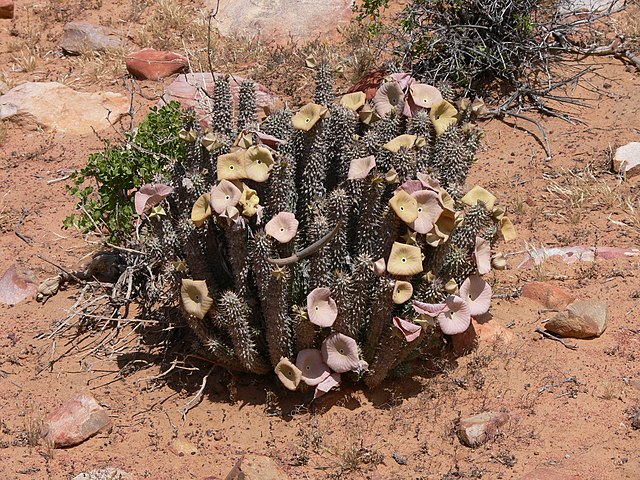
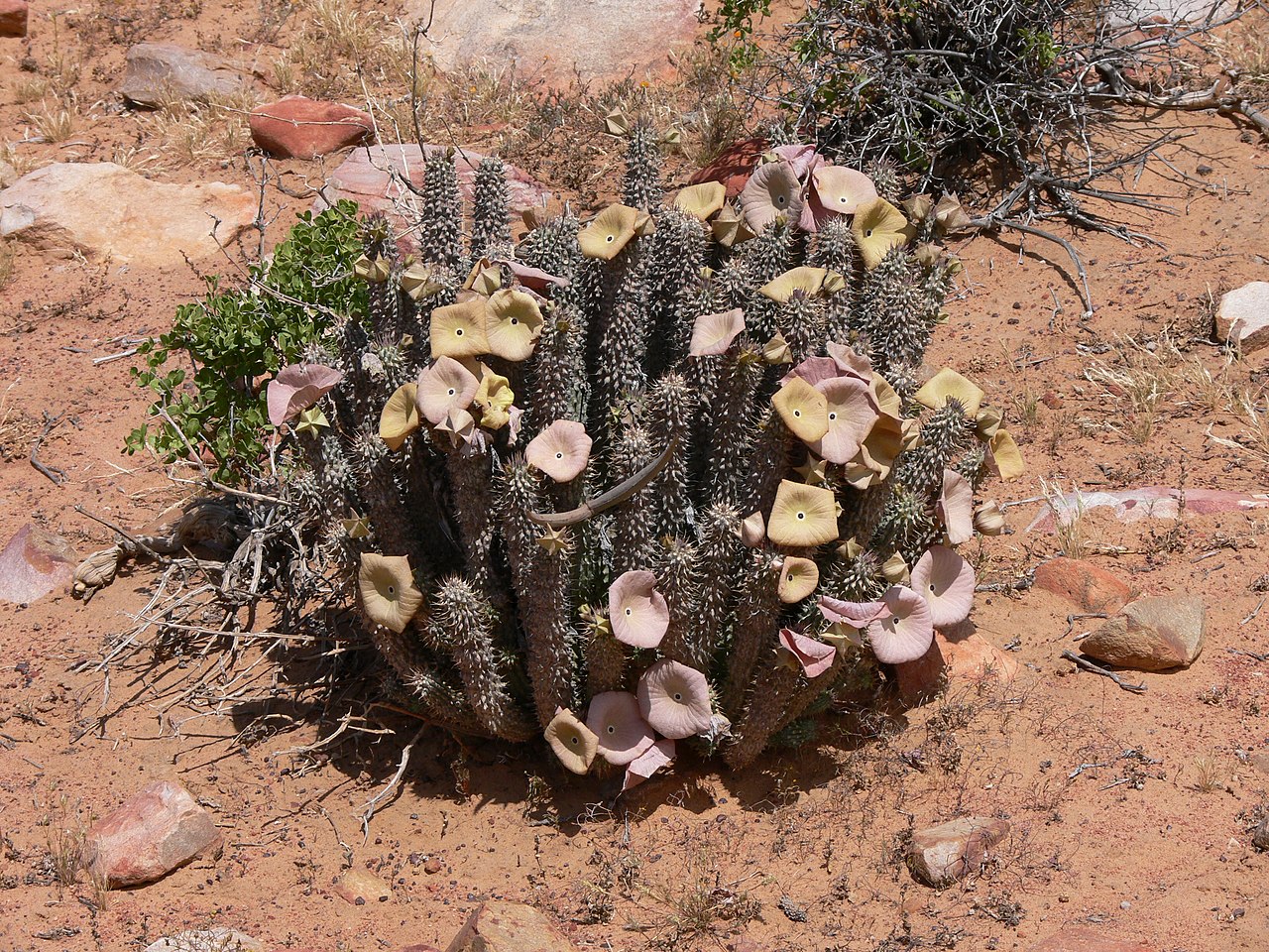
Hoodia gordonii in the Cederberg, South Africa
Summary[edit]
| Description |
Afrikaans: Hoodia gordonii (Masson) Sweet ex Decne, bekend as bobbejaanghaap, bergghaap, bitterghaap of bokhorings, in die Biedouwvallei-munisipaliteit, Cederberg, Wes-Kaap, Suid-Afrika
Català: Hoodia gordonii (Masson) Sweet ex Decne, Biedouw Valley, Cap Occidental, Sud-àfrica
Čeština: Hoodia gordonii (Masson) Sweet ex Decne, Biedouw Valley, Západní Kapsko, Jihoafrická republika
Dansk: Hoodia gordonii (Masson) Sweet ex Decne, Biedouw Valley, Kommune Cederberg, Vest-Kapprovinsen, Sydafrika
Deutsch: Hoodia gordonii (Masson) Sweet ex Decne, Biedouw Valley, Gemeinde Cederberg, Westkap, Südafrika
English: Bushman's hat, Queen of the Namib, Hoodia gordonii (Masson) Sweet ex Decne, Biedouw Valley, Cederberg Local Municipality, Western Cape, South Africa
Esperanto: Hoodia gordonii (Masson) Sweet ex Decne, Biedouw Valley, Komunumo Cederberg, Okcidenta Kablando, Sud-Afriko
Español: Hoodia gordonii (Masson) Sweet ex Decne, Biedouw Valley, Comuna Cederberg, Provincia Occidental del Cabo, Sudáfrica
Eesti: Hoodia gordonii (Masson) Sweet ex Decne, Biedouw Valley, Lääne-Kapimaa, Lõuna-Aafrika Vabariik
Suomi: Hoodia gordonii (Masson) Sweet ex Decne, Biedouw Valley, Kunta Cederberg, Western Cape, Etelä-Afrikka
Français : Cactus coupe faim, Hoodia gordonii (Masson) Sweet ex Decne, Biedouw Valley, Commune Cederberg, Cap-Occidental, d'Afrique du Sud
Galego: Hoodia gordonii (Masson) Sweet ex Decne, Biedouw Valley, Concello Cederberg, Cabo Occidental, Sudáfrica
Magyar: Hoodia gordonii (Masson) Sweet ex Decne, Biedouw Valley, Dél-afrikai Köztársaság
Italiano: Hoodia gordonii (Masson) Sweet ex Decne, Biedouw Valley, Comune Cederberg, Western Cape, Sudafrica
Lëtzebuergesch: Hoodia gordonii (Masson) Sweet ex Decne, Biedouw Valley, Westkaap, Südafrika
Lietuvių: Hoodia gordonii (Masson) Sweet ex Decne, Biedouw Valley, Vakarų Kapas, Pietų Afrikos Respublikos
Nederlands: Hoodia gordonii (Masson) Sweet ex Decne, Biedouw Valley, Gemeente Cederberg, West-Kaap, Zuid-Afrika
Norsk bokmål: Hoodia gordonii (Masson) Sweet ex Decne, Biedouw Valley, Kommune Cederberg, Western Cape, Sør-Afrika
Polski: Trojeściowate, Hoodia gordonii (Masson) Sweet ex Decne, Biedouw Valley, Prowincja Przylądkowa Zachodnia, Republika Południowej Afryki
Português: Hoodia gordonii (Masson) Sweet ex Decne, Biedouw Valley, Município Cederberg, Cabo Ocidental, África do Sul
Русский: Ластовнёвые, Hoodia gordonii (Masson) Sweet ex Decne, Biedouw Valley, Община Cederberg, Западная Капская провинция, Южно-Африканская Республика
Slovenčina: Hoodia gordonii (Masson) Sweet ex Decne, Biedouw Valley, Západné Kapsko , Republika Južna Afrika
Slovenščina: Hoodia gordonii (Masson) Sweet ex Decne, Biedouw Valley, Občina Cederberg, Zahodna Kaplandija, Republika Južna Afrika
Svenska: Flugtallriksläktet, Hoodia gordonii (Masson) Sweet ex Decne, Biedouw Valley, Kommun Cederberg, Västra Kapprovinsen, Sydafrika |
| Date | |
| Source | Own work |
| Author | Winfried Bruenken (Amrum) |
Licensing[edit]
I, the copyright holder of this work, hereby publish it under the following license:
This file is licensed under the Creative Commons Attribution-Share Alike 2.5 Generic license.
- You are free:
- to share – to copy, distribute and transmit the work
- to remix – to adapt the work
- Under the following conditions:
- attribution – You must give appropriate credit, provide a link to the license, and indicate if changes were made. You may do so in any reasonable manner, but not in any way that suggests the licensor endorses you or your use.
- share alike – If you remix, transform, or build upon the material, you must distribute your contributions under the same or compatible license as the original.
| Camera location | | View this and other nearby images on: OpenStreetMap |
|---|
File history
Click on a date/time to view the file as it appeared at that time.
| Date/Time | Thumbnail | Dimensions | User | Comment | |
|---|---|---|---|---|---|
| current | 23:18, 14 July 2006 | | 3,264 × 2,448 (3.95 MB) | Amrum (talk | contribs) | {{Information |Description= |Source=own work |Date=20.10.2005 |Author=Winfried bruenken |Permission=frei |other_versions= }} |
You cannot overwrite this file.
File usage on Commons
The following 4 pages use this file:
File usage on other wikis
The following other wikis use this file:
- Usage on af.wikipedia.org
- Usage on ar.wikipedia.org
- Usage on arz.wikipedia.org
- Usage on ast.wikipedia.org
- Usage on be.wikipedia.org
- Usage on ca.wikipedia.org
- Usage on ceb.wikipedia.org
- Usage on de.wikipedia.org
- Usage on en.wikipedia.org
- Usage on eo.wikipedia.org
- Usage on es.wikipedia.org
- Usage on fa.wikipedia.org
- Usage on fi.wikipedia.org
- Usage on fr.wikipedia.org
- Usage on he.wikipedia.org
- Usage on it.wikipedia.org
- Usage on ja.wikipedia.org
- Usage on nl.wikipedia.org
- Usage on nl.wiktionary.org
- Usage on pt.wikipedia.org
- Usage on ru.wikipedia.org
- Usage on species.wikimedia.org
- Usage on sv.wikipedia.org
- Usage on tr.wikipedia.org
- Usage on uk.wikipedia.org
- Usage on vi.wikipedia.org
- Usage on war.wikipedia.org
View more global usage of this file.