File:Hong Kong Railway Route Map ring.svg
Jump to navigation
Jump to search

Size of this PNG preview of this SVG file: 600 × 600 pixels. Other resolutions: 240 × 240 pixels | 480 × 480 pixels | 768 × 768 pixels | 1,024 × 1,024 pixels | 2,048 × 2,048 pixels | 1,600 × 1,600 pixels.
Original file (SVG file, nominally 1,600 × 1,600 pixels, file size: 55 KB)
Captions
Captions
Add a one-line explanation of what this file represents
| Description |
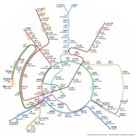
English: Hong Kong MTR diagram in concentric ring pattern, assuming East Kowloon Line and North Island Line are completed.
|
|||
| Date | 14 May 2016, 04:17:16 (upload date) | |||
| Source | Own work | |||
| Author | Sameboat | |||
| Permission (Reusing this file) |
I, the copyright holder of this work, hereby publish it under the following license: This file is licensed under the Creative Commons Attribution-Share Alike 4.0 International license.
|
|||
| Other versions |
|

This vector image was created with a text editor.
Please do not replace the simplified code of this file with a version created with Inkscape or any other vector graphics editor
- The English station labels in this diagram use semi-bold weight of Myriad Pro. The markup in this file
font-family:Myriad Pro Light;font-weight:boldONLY works in Windows XP. In Windows 7 this must be changed tofont-family:Myriad Pro;font-weight:600for correct font variant.
File history
Click on a date/time to view the file as it appeared at that time.
| Date/Time | Thumbnail | Dimensions | User | Comment | |
|---|---|---|---|---|---|
| current | 14:59, 15 July 2018 | | 1,600 × 1,600 (55 KB) | Sameboat (talk | contribs) | doctype and validate |
| 00:03, 26 May 2018 |  | 1,600 × 1,600 (55 KB) | Sameboat (talk | contribs) | Tuen Ma Line | |
| 09:12, 28 November 2017 |  | 1,600 × 1,600 (55 KB) | Sameboat (talk | contribs) | ||
| 12:52, 18 June 2016 |  | 1,600 × 1,600 (55 KB) | Jc86035 (talk | contribs) | if you're going to use Inkscape's text-to-path please just make another file, it's difficult to edit properly. also try using xlink because the file size is too big | |
| 12:18, 18 June 2016 |  | 1,600 × 1,600 (1.46 MB) | Emphrase (talk | contribs) | Reverted to version as of 10:48, 18 June 2016 (UTC) | |
| 11:02, 18 June 2016 |  | 1,600 × 1,600 (55 KB) | Jc86035 (talk | contribs) | Reverted to version as of 10:53, 12 June 2016 (UTC) | |
| 10:48, 18 June 2016 |  | 1,600 × 1,600 (1.46 MB) | Emphrase (talk | contribs) | converted text into paths | |
| 10:53, 12 June 2016 |  | 1,600 × 1,600 (55 KB) | Sameboat (talk | contribs) | Add terminus line icon to make it colorblind-friendly | |
| 08:38, 1 June 2016 |  | 1,600 × 1,600 (51 KB) | Sameboat (talk | contribs) | minor | |
| 01:13, 31 May 2016 |  | 1,600 × 1,600 (51 KB) | Sameboat (talk | contribs) | feOffset instead of transform/translate |
You cannot overwrite this file.
File usage on Commons
The following 39 pages use this file:
- User:Chumwa/OgreBot/Potential transport maps/2016 June 1-10
- User:Chumwa/OgreBot/Potential transport maps/2016 June 11-20
- User:Chumwa/OgreBot/Potential transport maps/2016 May 11-20
- User:Chumwa/OgreBot/Potential transport maps/2016 May 21-31
- User:Chumwa/OgreBot/Potential transport maps/2017 November 21-30
- User:Chumwa/OgreBot/Potential transport maps/2018 July 11-20
- User:Chumwa/OgreBot/Potential transport maps/2018 May 21-31
- User:Chumwa/OgreBot/Public transport information/2016 June 1-10
- User:Chumwa/OgreBot/Public transport information/2016 June 11-20
- User:Chumwa/OgreBot/Public transport information/2016 May 11-20
- User:Chumwa/OgreBot/Public transport information/2016 May 21-31
- User:Chumwa/OgreBot/Public transport information/2017 November 21-30
- User:Chumwa/OgreBot/Public transport information/2018 July 11-20
- User:Chumwa/OgreBot/Public transport information/2018 May 21-31
- User:Chumwa/OgreBot/Transport Maps/2016 June 1-10
- User:Chumwa/OgreBot/Transport Maps/2016 June 11-20
- User:Chumwa/OgreBot/Transport Maps/2016 May 11-20
- User:Chumwa/OgreBot/Transport Maps/2016 May 21-31
- User:Chumwa/OgreBot/Transport Maps/2017 November 21-30
- User:Chumwa/OgreBot/Transport Maps/2018 July 11-20
- User:Chumwa/OgreBot/Transport Maps/2018 May 21-31
- User:Chumwa/OgreBot/Travel and communication maps/2016 June 1-10
- User:Chumwa/OgreBot/Travel and communication maps/2016 June 11-20
- User:Chumwa/OgreBot/Travel and communication maps/2016 May 11-20
- User:Chumwa/OgreBot/Travel and communication maps/2016 May 21-31
- User:Chumwa/OgreBot/Travel and communication maps/2017 November 21-30
- User:Chumwa/OgreBot/Travel and communication maps/2018 July 11-20
- User:Chumwa/OgreBot/Travel and communication maps/2018 May 21-31
- User:OgreBot/Watercraft/2016 June 1-5
- User:OgreBot/Watercraft/2016 June 11-15
- User:OgreBot/Watercraft/2016 June 16-20
- User:OgreBot/Watercraft/2016 May 13-16
- User:OgreBot/Watercraft/2016 May 17-21
- User:OgreBot/Watercraft/2016 May 27-31
- User:OgreBot/Watercraft/2017 November 28
- User:OgreBot/Watercraft/2018 July 15
- User:OgreBot/Watercraft/2018 May 26
- User:Sameboat
- File:Hong Kong Railway Route Map ring.pdf