File:Hong Kong 18-25 December 1941.jpg

From Wikimedia Commons, the free media repository
Jump to navigation Jump to search

Original file(1,200 × 811 pixels, file size: 243 KB, MIME type: image/jpeg)

Captions

Captions

Shows how the war was going during 18-25 December 1941. Shows the Japanese lines of advance and other geological information
Description
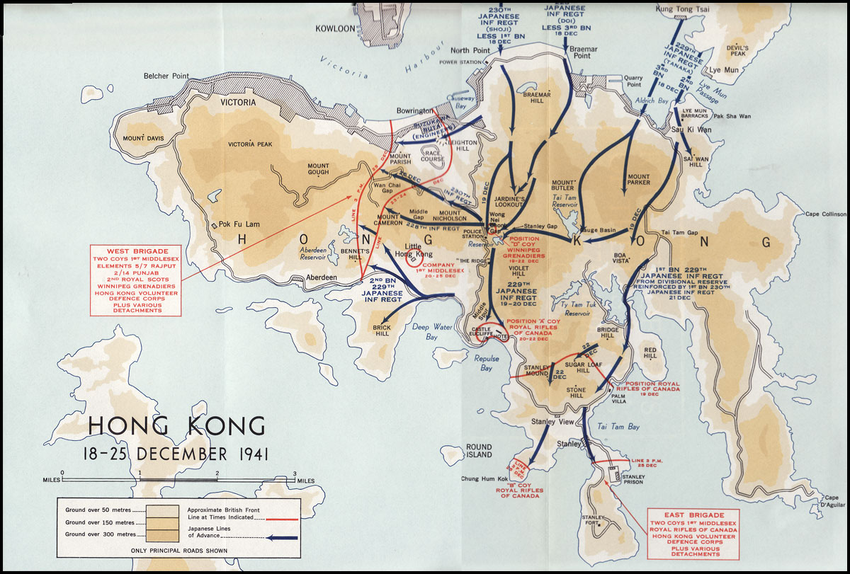
English: Colour map of the Japanese invasion of Hong Kong, December 18–25, 1941
Date
Source Stacey, C. P., maps drawn by C. C. J. Bond (1956) [1955]. Official History of the Canadian Army in the Second World War. Volume I: Six Year of War: The Army in Canada, Britain and the Pacific (via ibiblio.org). Ottawa: By Authority of the Minister of National Defence. OCLC 917731527). Map compiled and drawn by Historical Section, General Staff, Canadian Army.
Author C. C. J. Bond / Historical Section, General Staff, Canadian Army
Permission
(Reusing this file)
Public domain
This Canadian work is in the public domain in Canada because its copyright has expired due to one of the following:
1. it was subject to Crown copyright and was first published more than 50 years ago, or

it was not subject to Crown copyright, and

2. it is a photograph that was created prior to January 1, 1949, or
3. the creator died prior to January 1, 1972.

You must also include a United States public domain tag to indicate why this work is in the public domain in the United States. Note that this work might not be in the public domain in countries that do not apply the rule of the shorter term and have copyright terms longer than life of the author plus 50 years. In particular, Mexico is 100 years, Jamaica is 95 years, Colombia is 80 years, Guatemala and Samoa are 75 years, Switzerland and the United States are 70 years, and Venezuela is 60 years.


العربية  বাংলা  čeština  Deutsch  English  español  suomi  français  italiano  日本語  한국어  македонски  മലയാളം  Nederlands  português  português do Brasil  sicilianu  slovenščina  简体中文  繁體中文  +/−

Copyrighted in the U.S. This work may not be in the public domain in the United States because its U.S. copyright was restored by the URAA as it was still copyrighted in its source country on the URAA date (January 1, 1996 in most cases but see Wikipedia:Non-U.S. copyrights for details). In most cases, it is copyrighted in the U.S. until 95 years after the year in which it was initially published (exceptions are works published after 1977; see Commons:Hirtle chart). This template may not be used for files uploaded after 1 March 2012.

If you are the copyright holder of this file, and do not wish to have it hosted on Commons, please contact our designated agent or nominate the file for deletion, explaining the situation.


Deutsch  English  español  français  italiano  sicilianu  slovenščina  Tiếng Việt  русский  മലയാളം  日本語  简体中文  繁體中文  +/−

Other versions

File history

Click on a date/time to view the file as it appeared at that time.

Date/TimeThumbnailDimensionsUserComment
current23:05, 6 April 2017Thumbnail for version as of 23:05, 6 April 20171,200 × 811 (243 KB)Prüm (talk | contribs){{Information |description={{en|1=Colour map of the Japanese invasion of Hong Kong, December 18–25, 1941}} |date=1955 |source=Stacey, C. P., maps drawn by C. C. J. Bond (1956) [1955]. ''[[:en:Official History of the Canadian Army in the Second World...

File usage on other wikis

The following other wikis use this file: