File:Holy Roman Empire 1000 map-fr.svg
Jump to navigation
Jump to search

Size of this PNG preview of this SVG file: 488 × 599 pixels. Other resolutions: 196 × 240 pixels | 391 × 480 pixels | 626 × 768 pixels | 834 × 1,024 pixels | 1,669 × 2,048 pixels | 1,000 × 1,227 pixels.
Original file (SVG file, nominally 1,000 × 1,227 pixels, file size: 558 KB)
Captions
Captions
Add a one-line explanation of what this file represents
Summary[edit]
| Description |
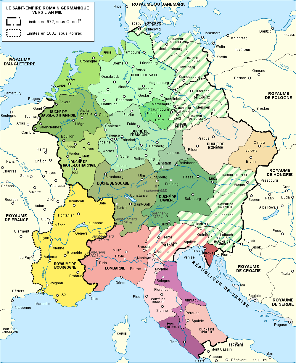
Deutsch: Karte des Heiligen Römischen Reiches um das Jahr 1000 (französische Version). English: Map of the Holy Roman Empire near year 1000. French version. Español: Mapa del Sacro Imperio Romano Germánico hacia el año 1000. Français : Carte du Saint-Empire romain germanique vers l'an mille. Русский: Карта Священной Римской империи около 1000 года. |
||
| Date | |||
| Source |
Own work. Source :
|
||
| Author | Sémhur | ||
| Other versions |
Derivative works of this file: []
| ||
| Attribution (required by the license) | © Sémhur / Wikimedia Commons / | ||
| SVG | W3C-validity not checked.
|
||
| Graphic Lab |


| Camera location | | View this and other nearby images on: OpenStreetMap |
|---|
Licensing[edit]
I, the copyright holder of this work, hereby publish it under the following licenses:
| Copyleft: This work of art is free; you can redistribute it and/or modify it according to terms of the Free Art License. You will find a specimen of this license on the Copyleft Attitude site as well as on other sites. |
This file is licensed under the Creative Commons Attribution-Share Alike Attribution-Share Alike 4.0 International, 3.0 Unported, 2.5 Generic, 2.0 Generic and 1.0 Generic license.
- You are free:
- to share – to copy, distribute and transmit the work
- to remix – to adapt the work
- Under the following conditions:
- attribution – You must give appropriate credit, provide a link to the license, and indicate if changes were made. You may do so in any reasonable manner, but not in any way that suggests the licensor endorses you or your use.
- share alike – If you remix, transform, or build upon the material, you must distribute your contributions under the same or compatible license as the original.
You may select the license of your choice.
File history
Click on a date/time to view the file as it appeared at that time.
| Date/Time | Thumbnail | Dimensions | User | Comment | |
|---|---|---|---|---|---|
| current | 09:26, 17 June 2017 | | 1,000 × 1,227 (558 KB) | M0tty (talk | contribs) | Ier |
| 20:34, 3 February 2017 |  | 1,000 × 1,227 (558 KB) | Sémhur (talk | contribs) | BOHÈME > BOHÊME | |
| 17:07, 26 July 2008 |  | 1,000 × 1,227 (556 KB) | Sémhur (talk | contribs) | {{Information |Description={{en|1=Map of the Holy Roman Empire near year 1000. French version}} {{fr|1=Carte du Saint-Empire romain germanique vers l'an mille.}} |Source=travail personnel (o |
You cannot overwrite this file.
File usage on Commons
The following 14 pages use this file:
- File:Holy Roman Empire 1000 map-bg.svg
- File:Holy Roman Empire 1000 map-de.png
- File:Holy Roman Empire 1000 map-de.svg
- File:Holy Roman Empire 1000 map-es.svg
- File:Holy Roman Empire 1000 map-fr.svg
- File:Holy Roman Empire 1000 map-ka.svg
- File:Holy Roman Empire 1000 map-ko.svg
- File:Holy Roman Empire 1000 map-ru.svg
- File:Holy Roman Empire 1000 map-uk.svg
- File:Holy Roman Empire 1000 map with more colours-fr.svg
- File:Holy Roman Empire 11th century map-en.svg
- File:Holy Roman Empire 11th century map-hu.svg
- File:Holy Roman Empire 11th century map-zh-hans.svg
- Template:Other versions/Holy Roman Empire 1000 map
File usage on other wikis
The following other wikis use this file:
- Usage on es.wikipedia.org
- Usage on fr.wikipedia.org
- Saint-Empire romain germanique
- Histoire de la Provence
- Histoire de la Drôme
- Otton Ier (empereur du Saint-Empire)
- Sylvestre II
- Otton II (empereur du Saint-Empire)
- Otton III (empereur du Saint-Empire)
- Chanson des Nibelungen
- Discussion:Otton Ier (empereur du Saint-Empire)
- Francie orientale
- Architecture ottonienne
- Histoire de la Franche-Comté
- Marche (juridiction)
- Duché de Franconie
- Art mosan
- Histoire de la Wallonie
- Duché de Bohême
- Comté de Provence
- Marche des Billung
- Provence
- Royaume de Germanie
- Wikipédia:Atelier graphique/Cartes/Archives/juillet 2008
- Royaume d'Arles
- Révolte des Saxons
- Patrimoine mosan en Wallonie
- Wikipédia:Atelier graphique/Images à améliorer/Archives/Août 2017
- Duché ethnique
- Rodolphiens
- Utilisateur:Mathious Ier/Histoire du Saint-Empire romain germanique
- Usage on fr.wiktionary.org
- Usage on hr.wikipedia.org
- Usage on oc.wikipedia.org
- Usage on sh.wikipedia.org
- Usage on sl.wikipedia.org
- Usage on vls.wikipedia.org