File:Historische Karte CH 1414.png
Jump to navigation
Jump to search

Size of this preview: 800 × 561 pixels. Other resolutions: 320 × 225 pixels | 640 × 449 pixels | 1,024 × 718 pixels | 1,280 × 898 pixels | 2,500 × 1,754 pixels.
Original file (2,500 × 1,754 pixels, file size: 1.08 MB, MIME type: image/png)
Captions
Captions
Add a one-line explanation of what this file represents
Summary[edit]
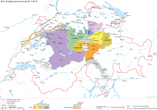
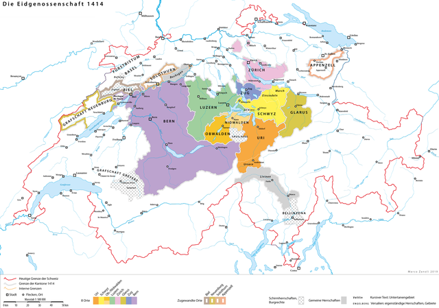
| Description | Karte der Eidgenossenschaft 1414 vor der Eroberung des Aargau |
| Date | |
| Source | Own work; Hektor Ammann / Karl Schib (Hg.), Historischer Atlas der Schweiz, Aarau 1958; Adolf Gasser, Die territoriale Entwicklung der Eidgenossenschaft 1291–1797, Sauerländer, Aarau 1932. |
| Author | sidonius (talk) 15:42, 6 January 2019 (UTC) |
Licensing[edit]
You may use my work outside wikipedia for free as long as you name me as the author. If you would like to use my work in a print medium, please send me a specimen copy.
Contact me if you have questions regarding the license or if you want individual changes to the map (marco.zanoli at hotmail.ch). This file is licensed under the Creative Commons Attribution-Share Alike 4.0 International license. Attribution: Marco Zanoli
|
File history
Click on a date/time to view the file as it appeared at that time.
| Date/Time | Thumbnail | Dimensions | User | Comment | |
|---|---|---|---|---|---|
| current | 15:42, 6 January 2019 | | 2,500 × 1,754 (1.08 MB) | Sidonius (talk | contribs) | {{Information |description=Karte der Eidgenossenschaft 1414 vor der Eroberung des Aargau |date=2019-01-06 |source=own work; Hektor Ammann / Karl Schib (Hg.), Historischer Atlas der Schweiz, Aarau 1958; Adolf Gasser, Die territoriale Entwicklung der Eidgenossenschaft 1291–1797, Sauerländer, Aarau 1932. |author=~~~~ |permission= |other versions= }} Category:1414 in Switzerland Category:1414 Category:Maps of the Old Confederacy |
You cannot overwrite this file.
File usage on Commons
The following page uses this file:
File usage on other wikis
The following other wikis use this file:
- Usage on de.wikipedia.org